Chandigarh Capital Region

Last updated

A map of Chandigarh, Mohali, Panchkula and Zirakpur together. Chandigarh Tricity.svg
A map of Chandigarh, Mohali, Panchkula and Zirakpur together.

Chandigarh Capital Region (CCR) or Chandigarh Metropolitan Region (CMR) is an area, which includes the union territory city of Chandigarh, and its neighboring cities of Mohali, Kharar, Zirakpur, New Chandigarh (in Punjab) and Panchkula, Pinjore, Kalka, Barwala (in Haryana). Chandigarh Administration, Greater Mohali Area Development Authority (GMADA) and Haryana Urban Development Authority (HUDA) are different authorities responsible for development of this region. [1] Baddi, an industrial town in nearby Himachal Pradesh, is also adjacent.

Contents

The economy of the region is interdependent as the area is continuously inhabited, though falling under different states. There is a lot of movement of people and goods daily to and from suburbs, like most of the people working in Chandigarh live in a suburb like Zirakpur. The local industry is on the outskirts like Derabassi, Lalru and Baddi. The vast majority of skilled workers in the private sector come from neighboring states like Himachal Pradesh, Punjab, and Haryana.

History

The Indian Ministry of Home Affairs asked the Chandigarh Administration in October 2011 to "coordinate with the Punjab and Haryana governments for working out the modalities" of a Regional Planning Board (RPB) for the Chandigarh Capital Region (CCR). The intention was to harmonize and improve facilities across the region and coordinate local administrations. Responsibilities of the RPB would include disaster management, health planning, biomedical waste and traffic management. [2] [3]

The 'Master Plan 2031' submitted to the UT administrator in January 2013 included a proposal for a "inter-state regional plan for the Chandigarh Capital Region". [4] However the final plan confined itself to the UT boundary, and did not mention the proposed "Chandigarh Capital Region". [5] Instead, the plan expected responsibilities for the region to be coordinated between Punjab, Haryana and Chandigarh UT, and that the Chandigarh plan "with the GMADA Plan 2056 and the Haryana Development Plan should together arrive at a metropolitan plan". [6]

As of May 2019 the Chandigarh capital region along the lines of the National Capital Region remains an un-implemented concept. [7]

Definition

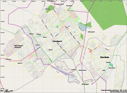
The cities, towns and areas that would be part of the Chandigarh Capital region have a total population of 3,358,653 and their city-wise populations are:

RankCityUnion territory / StatePopulation (2011) [8]
1 Chandigarh Chandigarh 1,055,450
2 Mohali Punjab 976,152
3 Panchkula Haryana 210,175
4 Kharar Punjab 221,323
5 New Chandigarh Punjab
6 Zirakpur Punjab 110,553

Mohali District (Punjab) and Panchkula District ( Haryana ) are part of the CCR

Derabassi, Lalru, Banur and Kurali in Mohali district. Kalka, Pinjore, Barwala and Raipur Rani in the Panchkula district can be considered another town in Chandigarh Capital Region

In future, it can be expanded up to BBN ( Baddi-Brotiwala-Nalagarh) Area in Himachal Pradesh and Rupnagar City in Punjab.

Industry

Chandigarh IT Park is a technology park located within Chandigarh, with presence of companies like Airtel, Tech Mahindra and Infosys.

Mohali IT City is the infrastructure to facilitate information technology in the city. It spreads over 1700 acres developed by GMADA situated near Chandigarh International Airport. Infosys is given 50 Acres of land to develop state of art campus.

Quark has 40 Acres campus in Mohali for Quark software Inc. and other IT Companies like Emerson and Infosys.

Swaraj Tractors has Three Assembly Plants , one Engine Plant and one Foundry shop in Mohali District. CLAAS, German MNC has its Plant near Morinda in Mohali District. SML ISUZU has truck Plant near Ropar. Verka and Sun Pharma also have Plants in Mohali.

Dera Bassi - Lalru is another belt with mostly medium industry, this place has many spinning mills including the Nahar group. Bhushan Steel also has a presence here.

Panchkula IT Park is the state of art infrastructure to facilitate information technology in the city. It spreads over 74 acres developed by HSIIDC situated in sector 22. Bharat Electronics has a factory in Panchkula.

Hindustan Machine Tools has a tractor factory in Pinjore, while Associated Cement Companies has a cement factory in Pinjore.

The metropolitan areas of Chandigarh, Mohali, and Panchkula collectively form a tri-city.

This region is the zonal headquarters for a large number of banks, their offices are mainly in the "Bank Square" in sector 17 Chandigarh. This area also houses the regional office (usually covering Punjab, Northern Haryana, Himachal Pradesh and Jammu and Kashmir) for a lot of FMCG companies.

Healthcare Infrastructure

The prominent hospitals in the region are

Educational Institutes

Schools


Colleges and Universities

Sports

Transport

Related Research Articles

<span class="mw-page-title-main">Chandigarh</span> Union territory and capital of Punjab and Haryana, India

Chandigarh is a union territory and planned city in northern India, serving as the shared capital of the surrounding states, namely Punjab to the north, west and the south, and Haryana to the east. Chandigarh constitutes the bulk of the Chandigarh Capital Region or Greater Chandigarh, which also includes the adjacent satellite cities of Panchkula in Haryana and Mohali in Punjab. It is situated near the foothills of the Himalayas, 260 km north of New Delhi and 229 km southeast of Amritsar.

<span class="mw-page-title-main">Panchkula district</span> District of Haryana in India

Panchkula district was formed as the 17th district of the Indian state of Haryana on 15 August 1995. It comprises two sub divisions and two tehsils: Panchkula and Kalka. It has 264 villages, out of which 12 are uninhabited and ten wholly merged with towns or treated as census towns according to the 1991 census. There are five towns in the district: Barwala, Kalka, Panchkula, Pinjore and Raipur Rani. The total population of the district is 319,398 out of which 173,557 are males and 145,841 are females.

<span class="mw-page-title-main">Kalka</span> Town in Haryana, India

Kalka is a town in the Panchkula district of Haryana, India. It is near Panchkula city. The name of the town is derived from the Hindu goddess Kali. It is situated in the foothills of the Himalayas and is a gateway to the neighbouring state of Himachal Pradesh. It is on the National Highway 5 between Chandigarh and Shimla, and it is the terminus of the Kalka-Shimla Railway. To the south of Kalka is Pinjore, and the industrial village of Parwanoo is to the north on NH 22. Railways and Industrial development have led to a continuous urban belt from Pinjore to Parwanoo, but Kalka gained major economic benefits due to only highway until 2010, Shimla. It is the tehsil of 253 nearby sub-villages. Nearby is Chandimandir Cantonment, where the Western Command of the Indian army is based. In 2013, the municipal committee of Kalka was dissolved and the administration was reassigned to Panchkula Municipal Corporation.

<span class="mw-page-title-main">Mohali</span> City in Punjab, India

Mohali, officially known as Sahibzada Ajit Singh Nagar, is a planned city in the Mohali district in Punjab, India, which is an administrative and a commercial hub lying south-west of Chandigarh. It is the headquarters of the Mohali district and one of the six Municipal Corporations of the State. It is officially named after Sahibzada Ajit Singh, the eldest son of Guru Gobind Singh.

<span class="mw-page-title-main">Panchkula</span> City in Haryana, India

Panchkula is a planned city and district headquarter in the Panchkula district in Haryana, India. It is a satellite town of the state capital Chandigarh. Panchkula is a border city with Punjab,Chandigarh and Himachal Pradesh. The origin of the name Panchkula came from the place where five irrigation canals meet. At present, it forms a part of an adjoining area to Chandigarh, Mohali, and Zirakpur. It is approximately 4 km (2.5 mi) southeast of Chandigarh, 105 km (65 mi) southwest of Shimla, 44 km (27 mi) from Ambala and 259 km (161 mi) northeast of New Delhi, the national capital. It is a part of the Chandigarh capital region or Greater Chandigarh. The Chandigarh-Mohali-Panchkula metropolitan region collectively forms a Chandigarh Tricity, with a combined population of over two million.

<span class="mw-page-title-main">Yadavindra Gardens</span> Garden in Pinjore, Haryana, India

Yadavindra Gardens, also known as Pinjore Gardens, is a historic 17th century garden located in Pinjore city of Panchkula district in the Indian state of Haryana. Panchkula city is nearby it. It is an example of the Mughal gardens architectural style, which was renovated by the Patiala dynasty Sikh rulers. The garden was built by Fidai Khan.

Dera Bassi is a satellite city of Chandigarh and a municipal council in Mohali district in the state of Punjab, India. Dera Bassi is located on the Chandigarh – Delhi National Highway, 8 km from Chandigarh. It is located within 20 km from Chandigarh, Mohali and Panchkula. It is strategically located near the boundary of Haryana, Punjab and Union territory of Chandigarh. Derabassi is most famous for its industrial belt, situated for the most part on Ramgarh and Barwala Road. The nearby sub town of Lalru was once a famous market for red chilli powder. The city and the nearby area host eight Engineering, B.Ed., Paramedical and Management institutes.

<span class="mw-page-title-main">Parwanoo</span> Town in Himachal Pradesh, India

Parwanoo or Parwanu is a municipal council in Solan district in the Indian state of Himachal Pradesh. It is an industrial town. It has Himachal's biggest wholesale market. First in 3rd-category(less than 3 lakhs population) of Swachh Vayu Sarvekshan award 2023 .It borders Panchkula district of Haryana, and is after the towns of Pinjore and Kalka on the Chandigarh Simla Highway. In fact it is separated by a river bed from the town of Kalka.

<span class="mw-page-title-main">Pinjore</span> Town in Haryana, India

Pinjore is a town in Panchkula district in the Indian state of Haryana. This residential 'township', located close to Panchkula, Chandigarh, is set over 1,800 feet above the sea level in a valley, overlooking the Sivalik Hills. Pinjore is known for Pinjore Gardens, Asia's best 17th Century Mughal garden, and the Hindustan Machine Tools (HMT) factory.

<span class="mw-page-title-main">Raipur Rani</span> Census Town in Haryana, India

Raipur Rani is a census town in Panchkula district in the Indian state of Haryana. It is located on the Panchkula city-Chandigarh-Nahan-Paonta Sahib-Dehradun highway 30 kilometres east from the Chandigarh-Mohali-Panchkula urban cities combine. It is about 20 kilometres from the Dera Bassi Industrial belt and 10 kilometres from the Barwala industrial estate. Narayangarh in the Ambala District is the next large town in its proximity.

<span class="mw-page-title-main">Zirakpur</span> Town in Punjab, India

Zirakpur is a satellite town, in Mohali District, Punjab, neighboring Mohali, Chandigarh in India. It is set on the foothills of Shivalik hills. It is part of the tehsil Dera Bassi. It is the gateway to Chandigarh from Delhi. It comprises mainly the following areas near Chandigarh Airport including VIP Road, Dhakoli, Lohgarh, Bhabat, Bishanpura, Kishanpura, Nabha, Gazipur, Baltana, Singhpura, Peer Muchalla and Dyalpura. This town is situated on the junction of national highways Himalayan Expressway, National Highway 5 (India) towards Shimla, Ambala Chandigarh Expressway towards Ambala and National Highway 7 (India) towards Patiala.

<span class="mw-page-title-main">Chandimandir Cantonment</span>

Chandimandir Cantonment is a military cantonment of the Indian Army located in Panchkula district at the foot of the Sivalik Hills adjoining Panchkula city in Haryana. It is the headquarters of the Western Command of the Indian Army.

<span class="mw-page-title-main">Baddi University of Emerging Sciences and Technology</span>

Baddi University of Emerging Sciences and Technology (BUEST), formerly the Institute of Engineering and Emerging Technology (IEET), commonly referred to as Baddi University, is a private university located at Baddi, Himachal Pradesh, India. It was recognized as a university in 2009.

<span class="mw-page-title-main">Puadh</span> Historic region in north India

Puadh is a historic region in north India that comprises parts of present-day Punjab, Haryana, Uttar Pradesh, Himachal Pradesh and the U.T. of Chandigarh, India. It has the Sutlej river in its north and covers the regions immediately south of the Ghaggar river. The people of the area are known as Puadhi and speak the Puadhi dialect of Punjabi. The capital cities of Puadh region are Rupnagar, Fatehgarh Sahib, Mohali, Patiala, Chandigarh, Nalagarh,Panchkula, Baddi ,Ambala, Yamunanagar

Chandigarh Metro is an approved rapid transit system to serve the Chandigarh Capital Region, which includes Chandigarh and adjacent areas in Punjab and Haryana states of India. In Phase-1, to be progressively built and operationalised between 2027 and 2034, 3 lines will connect tri-cities of Chandigarh, Mohali in Punjab and Panchkula in Haryana. Phase-2, to be constructed after 2034, will connect Pinjore in Haryana and further expand the network in Mohali with 2 more lines. The project, which was initially scrapped in 2017 due to low financial viability, was approved in March 2023 and received formal clearance in July 2023 from the governments of Punjab and Haryana after a Detailed Project Report (DPR) was created.

<span class="mw-page-title-main">Lalru</span> Town in Punjab, India

Lalru is a town and a Municipal Council In Mohali District about 30 km from Chandigarh, the capital of both Haryana and Punjab, on the Chandigarh-Ambala National Highway, NH 22. Lalru is having one of the toll tax barriers on this Chandigarh - Delhi National Highway. It is part of Greater Mohali and Chandigarh Capital Region (CCR) or Chandigarh Metropolitan Region (CMR), Which is an area, which includes the union territory city of Chandigarh, and its neighboring cities of Mohali, Zirakpur, New Chandigarh, and Panchkula. Chandigarh Administration, Greater Mohali Area Development Authority (GMADA) and Haryana Urban Development Authority (HUDA) are different authorities responsible for the development of this region.

<span class="mw-page-title-main">Himalayan Expressway</span> Road in India

The Himalayan Expressway is a 27.5 km stretch of highway in India that runs through the Shivaliks at the trijunction of Haryana, Punjab, and Himachal Pradesh. It is part of the Chandigarh–Shimla Expressway which connects Zirakpur in Punjab to Parwanoo in Himachal Pradesh. It forms part of National Highway 5. The stretch runs through 2 km in Zirakpur, Punjab, 21 km in Panchkula, Haryana, and 4.5 km in Parwanoo, Himachal Pradesh. It was constructed by Jaypee Group.

Kajauli Waterworks is water supply department of Punjab located on the Bhakra mainline canal near Morinda in Ropar. It completes the water requirement of Chandigarh, Mohali and Chandimandir.

<span class="mw-page-title-main">National Highway 5 (India)</span> National highway in North India

National Highway 5 (NH5) is a primary national highway in India, running from West to East, connecting Firozpur in Punjab to the Sino-Indian border at Shipki La. The highway passes through Moga, Jagraon, Ludhiana, Mohali, Chandigarh, Panchkula, Kalka, Solan, Shimla, Theog, Narkanda, Kumarsain, Rampur Bushahr and continues along the Sutlej River till its terminus near the Tibet border.

<span class="mw-page-title-main">Haryana State Industrial and Infrastructure Development Corporation</span> State-owned agency of the government of Haryana, India

Haryana State Industrial and Infrastructure Development Corporation (HSIIDC), formerly Haryana State Industrial Development Corporation (HSIDC), headquartered at Panchkula, is a 100% state-owned agency of the government of Haryana in the Indian state of Haryana. For ease of doing business, Haryana is the first state in India to introduce a labour policy in 2005 and Land Pooling Policy in 2017, for which HSIIDC acts as the nodal agency. Haryana Financial Corporation provides financial assistance for setting up new industrial units and for the expansion and diversification of the existing industries. Various universities, educational and training institutes, including the nation's first skills university Haryana Vishwakarma Skill University, provide the human resources to capitalise on the infrastructure created by the HSIIDC.

References

  1. "Beware! Change in city's status will ruin its uniqueness". The Tribune. 23 July 2018. Retrieved 3 January 2019.
  2. "Decks cleared for Chandigarh Capital Region". The Times of India . Archived from the original on 7 October 2011.
  3. "Chandigarh Capital Region gets nod". Daily Post India . Chandigarh. 24 January 2012. Archived from the original on 8 April 2013.
  4. "Chandigarh Capital Region included in Master Plan '31". The Times of India . Archived from the original on 11 April 2013.
  5. "Chandigarh Master Plan 2031, Preamble" (PDF). Chandigarh Administration. p. 9.
  6. "Chandigarh Master Plan 2031, Regional Context" (PDF). Chandigarh Administration. p. 23.
  7. Yadav, Deepak (5 May 2015). "First steps to make Tricity one". The Times of India .
  8. "India: Major Agglomerations". .citypopulation.de. Retrieved 14 December 2014.

30°38′52″N76°27′14″E / 30.6476695°N 76.4539836°E / 30.6476695; 76.4539836