
Durham Wildlife Trust, founded in 1971, is a registered charity which aims to protect wildlife and promote nature conservation in parts of County Durham and Tyne and Wear, England. It is one of 46 such organisations that together constitute The Wildlife Trusts Partnership.

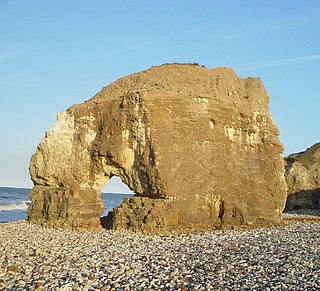
Bishop Middleham Quarry is a disused quarry, about 4 kilometres (2.5 mi) north-west of Sedgefield, County Durham, England. Quarry-working here ceased in 1934, and the site has since been colonised by vegetation. The underlying rock is Magnesian Limestone and this has had a strong influence in determining the range of plant and animal communities now found there.
The Durham Coast is a Site of Special Scientific Interest in County Durham, England. Starting just south of Crimdon Dene, north of Hartlepool, it extends, with a few interruptions, northward to the mouth of the River Tyne at South Shields. Notable locations on the Durham Coast include; Seaham, Sunderland Docks and Whitburn Beach.

Barnack Hills & Holes is a 23.3 hectare biological Site of Special Scientific Interest in Barnack in Cambridgeshire. It is also a national nature reserve. It is a Nature Conservation Review site, Grade I. In 2002 it was designated as a Special Area of Conservation, to protect the orchid-rich grassland as part of the Natura 2000 network of sites throughout the European Union.

Cassop Vale is a Site of Special Scientific Interest in the Durham City district of County Durham, England. It lies between the villages of Bowburn and Cassop, 7 km south-east of the centre of Durham..
Trimdon Limestone Quarry is a Site of Special Scientific Interest in the Sedgefield district of County Durham, England. It lies about 1 km west of the village of Trimdon Grange and about 5 km east of the village of Coxhoe.
Fishburn Grassland is a Site of Special Scientific Interest in the Sedgefield district of County Durham, England. It lies between the villages of Fishburn and Trimdon, just north of the former.
Hesledon Moor East is a Site of Special Scientific Interest in the County Durham district in east County Durham, England. It is located on the southern edge of the village of Murton, 10 km south of Sunderland and a little under 2 km north-east of Hesledon Moor West SSSI.
Lune Forest is a Site of Special Scientific Interest covering an extensive area of moorland in the Teesdale district of west Durham, England. In the north, where it adjoins the Upper Teesdale and Appleby Fells SSSIs, it extends from Mickle Fell eastward almost as far as Harter Fell, above the hamlet of Thringarth. Its southern limit is marked by the River Balder, upstream from Balderhead Reservoir, where it shares a boundary with Cotherstone Moor SSSI to the south. Grains o' th' Beck Meadows and Close House Mine SSSIs are entirely surrounded by Lune Forest, but do not form part of it.
Quarrington Hill Grasslands is a Site of Special Scientific Interest in County Durham, England. The site consists of three separate areas, two closely adjacent to the east of the village of Quarrington Hill, the third immediately west of the village, which lies 8 km south-east of Durham City.
Tuthill Quarry is a Site of Special Scientific Interest in the County Durham district of north-east County Durham, England. It lies just over 1 km east of the village of Haswell.
Raisby Hill Grassland is a Site of Special Scientific Interest in east County Durham, England. It lies just over 1 km east of the village of Coxhoe.
The Carrs is a Site of Special Scientific Interest in the Sedgefield district of County Durham, England. It is situated on the eastern outskirts of Ferryhill, between the town and the East Coast Main Line railway.
Thrislington Plantation is a Site of Special Scientific Interest and a national nature reserve in the Sedgefield district of County Durham, England. It is situated about 1 km east of Ferryhill, between the East Coast Main Line railway and the A1(M) road.

Wotton Hill is a hill on the edge of the Cotswold Hills in Gloucestershire, England, 0.5 miles (0.80 km) north of Wotton-under-Edge. The Cotswold Way passes over the hill.
Cockleford Marsh is a 3.2-hectare (7.9-acre) biological Site of Special Scientific Interest in Gloucestershire, notified in 1991.

Cotswold Commons and Beechwoods is a 665.5-hectare (1,644-acre) biological Site of Special Scientific Interest in Gloucestershire, notified in 1954.

Tudor Farm Bank is a 3.68-hectare (9.1-acre) biological Site of Special Scientific Interest in Gloucestershire, notified in 1999.

Quarry Moor is a Site of Special Scientific Interest, or SSSI, at the south edge of Ripon, North Yorkshire, England, and adjacent to the A61 road. It contains an outcrop of Magnesian Limestone, exposed by former quarrying. 255 million years ago this limestone was the peripheral sediment of a tropical sea. The land was donated in 1945 to the people of Ripon by the town's mayor, Alderman Thomas Fowler Spence, a varnish manufacturer. The land was notified as an SSSI in 1986 because its calcareous grassland supported a large diversity of plant species. The site features a Schedule 8 protected plant, thistle broomrape. The land is protected as a nature reserve, and it is also managed as a recreational area. Therefore, its calcareous grass area is fenced off for protection and study, but it also contains a car park, information signs, a children's play area, accessible paths, benches, and dog waste bins.
