Castle Eden Dene

Last updated
Castle Eden Dene
Gunners Pool Bridge, Castle Eden Dene.jpg
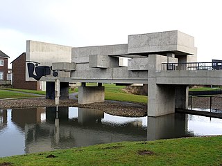
Gunners Pool Bridge in Castle Eden Dene
Durham UK relief location map.jpg
Red pog.svg
Site of Special Scientific Interest
Location MAGiC MaP
Nearest town Peterlee
Coordinates 54°45′0″N1°19′35″W / 54.75000°N 1.32639°W / 54.75000; -1.32639
Area192.97 ha (476.8 acres)
Established1984 (SSSI)
Governing body Natural England
Website Castle Eden Dene SSSI

Castle Eden Dene is a Site of Special Scientific Interest and National Nature Reserve in the Easington district of County Durham, England. It is located mostly in Peterlee, between the A19 and A1086 roads.

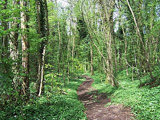
The dene is the largest, and biologically the richest, of a series of deep ravines that have been incised through the Magnesian Limestone and overlying boulder clay of coastal Durham by streams flowing into the North Sea. It is the largest area of semi-natural woodland in north-east England and, because the steep valley sides are mostly inaccessible, it has suffered relatively little from human interference. [1]

The majority of the woodland is dominated by ash, Fraxinus excelsior , and wych elm, Ulmus glabra , though sycamore, Acer pseudoplatanus is well-established and yew, Taxus baccata , is common. [2]

The yew is said to have given the dene its name, "Eden" being derived from the earlier "Yoden", or Yew dene, [1] though an alternative explanation is that "Eden" and "Yoden" derive from Old English Idun, itself a derivative of Indo-European pid, meaning "a spring, water". [3]

Over 450 species of plants have been recorded in the wood, many of which are typical of ancient woodlands that date back to pre-medieval times. The ground-flora is dominated by ramsons, or wild garlic, Allium ursinum, with its characteristic garlic-like aroma; dog's mercury, Mercurialis perennis and sanicle, Sanicula europaea , are also common, while locally-rare species include lily-of-the-valley, Convallaria majalis , herb paris, Paris quadrifolia , bird's-nest orchid, Neottia nidus-avis , and round-leaved wintergreen, Pyrola rotundifolia . [2]

In early spring, the woodland floor is scattered with the yellow flowers of primrose, Primula vulgaris , lesser celandine, Ranunculus ficaria , wild garlic Allium ursinum (producing the distinctive smell of garlic in the air when flowering) and the white flowers of wood anemone, Anemone nemorosa , which give way in late spring to thick carpets of bluebells, Hyacinthoides non-scripta .

The Dene is a popular venue for walkers and there are several entrances, from Peterlee and Horden to the north, Castle Eden, Blackhall and Heselden to the south, and from the A19 and A1086 roads. Natural England, which manages the area in partnership with local councils, has done much to improve access within the dene, both by strengthening the paths and bridges across the burn and by creating better drainage around the paths. [4] Despite this, heavy rain storms can severely disrupt access to some areas. Storms in July 2009 and November 2012 have left several areas inaccessible and some stretches of path may have to be closed permanently because of the instability of the valley slopes. [5] Similarly, although Castle Eden Burn is seasonal, and there is often no running water at the bottom of the ravine, the culvert which carries the burn under the A1086 road can become blocked with logs after heavy rain storms.

To minimise accidents and to avoid damage to the plants and the dene itself, Natural England advises walkers not to stray from the paths and prohibits the use of bicycles and motorbikes within the reserve. [1]

Pictures

Related Research Articles

<span class="mw-page-title-main">Peterlee</span> Town in County Durham, England

Peterlee is a town in County Durham, England, with Sunderland to the north, Hartlepool to the south, the Durham Coast to the east and Durham to the west. It gained town status in 1948 under the New Towns Act 1946. The act also created the nearby settlement of Newton Aycliffe and later Washington, Tyne and Wear.

<span class="mw-page-title-main">A19 road</span> Road in Northern England

The A19 is a major road in England running approximately parallel to and east of the A1 road. Although the two roads meet at the northern end of the A19, the two roads originally met at the southern end of the A19 in Doncaster, but the old route of the A1 was changed to the A638. From Sunderland northwards, the route was formerly the A108. In the past the route was known as the East of Snaith-York-Thirsk-Stockton-on-Tees-Sunderland Trunk Road. Most traffic joins the A19, heading for Teesside, from the A168 at Dishforth Interchange.

<span class="mw-page-title-main">A1086 road</span> Road in England

The A1086 is a road in County Durham, north-east England.

<span class="mw-page-title-main">Hesleden</span> English village in County Durham

Hesleden is a village in County Durham, England, south of Peterlee. The name is a combination of Dene and Hesle, which is from "hazel". The combined population of the five communities making up the parish of Monk Hesleden was 5,722 at the 2011 Census.

Castle Eden is a village in County Durham, in England. The population of the parish at the 2011 census was 642. It is situated a short distance to the south of Peterlee, Wingate, Hutton Henry, the A19 and Castle Eden Dene. The village is famous for the former Castle Eden Brewery which was home of the famous Castle Eden Ale; most of it was demolished in 2003 for a new housing estate and only the main front building remains today. This is a listed building and is now managed office space with a popular Italian restaurant. The A19 used to run through the village until it was bypassed in the 1970s. The deep and impressive nearby dene extends all the way to the sea, and its many yew trees are a particular feature where they find the dolomite soil advantageous.

<span class="mw-page-title-main">Horden</span> Village in County Durham, England

Horden is a village and electoral ward in County Durham, England. It is situated on the North Sea coast, to the east of Peterlee, approximately 12 miles south of Sunderland. Horden was a mining village until the closure of the Horden Colliery in 1987. Main features include the Welfare and Memorial Parks and St Mary's church. It is connected to the villages of Blackhall Colliery and Blackhall Rocks to its south by a spectacular rail viaduct which spans Castle Eden Dene near Denemouth. Horden Dene provides Horden's northern boundary with Easington Colliery.

<span class="mw-page-title-main">Lower Woods</span>

Lower Woods is a 280.1-hectare (692-acre) biological and geological Site of Special Scientific Interest near the village of Wickwar, South Gloucestershire, notified in 1966 and renotified in 1985. The site area has increased at last revision in 1974 to a 284.1-hectare (702-acre) site. The site is a nature reserve managed by the Gloucestershire Wildlife Trust.

<span class="mw-page-title-main">Midger</span>

Midger is a 65.7-hectare (162-acre) biological Site of Special Scientific Interest straddling the border of Gloucestershire and South Gloucestershire, notified in 1966 and renotified in 1984. Since the last revision in 1974, the size has been reduced to a 56-hectare (140-acre) site. It lies east of Hillesley, Gloucestershire and north of Hawkesbury Upton, South Gloucestershire. It is at the head of the Kilcott Valley.

<span class="mw-page-title-main">Fiddler's Elbow National Nature Reserve</span>

Fiddler's Elbow National Nature Reserve is a steep sided, woodland national nature reserve of 45 hectares in the Upper Wye Valley to the north of Monmouth in Wales, close to the Wales–England border. It is designated as a Site of Special Scientific Interest (SSSI) for its biological characteristics, containing a wide variety of flora.

<span class="mw-page-title-main">Grass Wood, Wharfedale</span> Ancient woodland in North Yorkshire, England

Grass Wood is an ancient woodland of 88 hectares in Wharfedale, North Yorkshire, England, that has an exceptional ground flora of woodland wildflowers.

Hawthorn Dene is a Site of Special Scientific Interest in the County Durham district of County Durham, England. The site occupies the incised valley of Hawthorn Burn and extends from just south of the village of Hawthorn eastward as far as the Durham Coast railway line: the area between the railway line and the sea forms part of the Durham Coast SSSI.

<span class="mw-page-title-main">Wensum Local Nature Reserve</span> Local Nature Reserve in Norwich, England

Wensum Local Nature Reserve or Wensum Valley is a Local Nature Reserve in Norwich in the English county of Norfolk. The reserve consists of two sites; Mile Cross Marsh52.6419°N 1.2657°E and Sycamore Crescent Wood which are linked by the Riverside Path a public footpath via the Sycamore Crescent footbridge

<span class="mw-page-title-main">Dizzard</span>

Dizzard is an area, in the civil parish of St Gennys, Cornwall, containing five farms. On the coast is Dizzard Point, and the unique, dwarf oak, Dizzard Wood, which is of international importance for its lichen communities.

<span class="mw-page-title-main">Clyde Valley Woodlands National Nature Reserve</span>

The Clyde Valley Woodlands National Nature Reserve (NNR) comprises six separate woodland sites in the Clyde Valley region of South Lanarkshire, Scotland. These six sites are located along a 12 km section of the River Clyde and its tributaries, and lie close to built-up areas such as Hamilton and Lanark on the southern outskirts of Greater Glasgow. The sites can be easily accessed by about two million people living in the surrounding urban areas, making the reserve unique amongst Scotland's NNRs, most of which tend to be located in more remote areas. The six sites are:

<span class="mw-page-title-main">Wotton Hill</span> Hill in Gloucestershire, England

Wotton Hill is a hill on the edge of the Cotswold Hills in Gloucestershire, England, 0.5 miles (0.80 km) north of Wotton-under-Edge. The Cotswold Way passes over the hill.

Lower Wye Gorge is a 65-hectare (160-acre) biological and geological Site of Special Scientific Interest in Gloucestershire, notified in 1954 and renotified 1987. The site includes two Gloucestershire Wildlife Trust nature reserves being Ban-y-gor Wood and Lancaut. The Natural England citation states a revision for Lancaut inclusion.

<span class="mw-page-title-main">Shorn Cliff and Caswell Woods</span> Biological Site of Special Scientific Interest in Gloucestershire, England

Shorn Cliff And Caswell Woods is a 69.2-hectare (171-acre) biological Site of Special Scientific Interest in Gloucestershire, notified in 1986. The site is listed in the 'Forest of Dean Local Plan Review' as a Key Wildlife Site (KWS).

References

  1. 1 2 3 "Castle Eden Dene NNR". Natural England . Retrieved 11 August 2010.
  2. 1 2 "Castle Eden Dene SSSI : Reasons for SSSI status" (PDF). Natural England. Retrieved 1 March 2022.
  3. Watts, Victor (2002). A Dictionary of County Durham Place-Names. English Place-Name Society. ISBN   0-904889-65-3.
  4. "Replacement of Dungy Bridge at Castle Eden Dene". Natural England. 21 January 2009. Archived from the original on 11 January 2011. Retrieved 11 August 2010.
  5. "Castle Eden Dene: open for visitors despite storm damage". Natural England. 28 July 2009. Archived from the original on 11 January 2011. Retrieved 11 August 2010.

Castle Eden Dene National Nature Reserve