| Teesdale Allotments | |
| Site of Special Scientific Interest | |
| Country | England |
|---|---|
| Region | North East |
| District | Teesdale |
| Location | NY930290 |
| - coordinates | 54°39′23″N2°6′33″W / 54.65639°N 2.10917°W Coordinates: 54°39′23″N2°6′33″W / 54.65639°N 2.10917°W |
| Area | 1,308.34 ha (3,233.0 acres) |
| Notification | 1994 |
| Management | Natural England |
| Area of Search | County Durham |
| Interest | Biological |
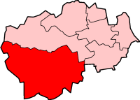
 Location of Teesdale Allotments SSSI, Co Durham | |
| Website: Map of site | |
Teesdale Allotments is a Site of Special Scientific Interest in the Teesdale district of County Durham, England. It consists of two large upland areas north of the Tees valley, one to the north and east of the village of Newbiggin, the other to the north-east of Middleton-in-Teesdale.

A Site of Special Scientific Interest (SSSI) in Great Britain or an Area of Special Scientific Interest (ASSI) in the Isle of Man and Northern Ireland is a conservation designation denoting a protected area in the United Kingdom and Isle of Man. SSSI/ASSIs are the basic building block of site-based nature conservation legislation and most other legal nature/geological conservation designations in the United Kingdom are based upon them, including national nature reserves, Ramsar sites, Special Protection Areas, and Special Areas of Conservation. The acronym "SSSI" is often pronounced "triple-S I".
Teesdale was, from 1974 to 2009, a local government district in County Durham, England. Its council was based in Barnard Castle and it was named after the valley of the River Tees.

County Durham is a county in North East England. The county town is Durham, a cathedral city. The largest settlement is Darlington, closely followed by Hartlepool and Stockton-on-Tees. It borders Tyne and Wear to the north east, Northumberland to the north, Cumbria to the west and North Yorkshire to the south. The county's historic boundaries stretch between the rivers Tyne and Tees, thus including places such as Gateshead, Jarrow, South Shields and Sunderland.
The area, which adjoins the Upper Teesdale SSSI, consists of enclosed upland grazings, and is of national importance for its bird populations. Species that breed in the area include Northern lapwing, common snipe, common redshank, Eurasian golden plover, black grouse and Eurasian curlew, all except the last of which are declining in numbers nationally. Densities of breeding waders are among the highest in Britain, with up to 90 pairs recorded from one 1 km square. [1]

Upper Teesdale is a Site of Special Scientific Interest (SSSI) in the Teesdale district of west County Durham, England. It encompasses an extensive upland area that includes the headwaters of the River Tees and the surrounding catchment area upstream of the village of Langdon Beck.

The northern lapwing, also known as the peewit or pewit, tuit or tew-it, green plover, or just lapwing, is a bird in the lapwing family. It is common through temperate Eurasia.

The common snipe is a small, stocky wader native to the Old World. The scientific name gallinago is New Latin for a woodcock or snipe from Latin gallina, "hen" and the suffix -ago, "resembling".
The black grouse population is particularly important: while this species has declined almost everywhere in England, and is now extinct in some former breeding areas, such as Dartmoor and Exmoor, the population in Teesdale has remained relatively stable, and the area now holds 30 percent of the English population, 7 percent of it in the Teesdale Allotments.

Dartmoor is a moor in southern Devon, England. Protected by National Park status as Dartmoor National Park, it covers 954 km2 (368 sq mi).

Exmoor is loosely defined as an area of hilly open moorland in west Somerset and north Devon in South West England. It is named after the River Exe, the source of which is situated in the centre of the area, two miles north-west of Simonsbath. Exmoor is more precisely defined as the area of the former ancient royal hunting forest, also called Exmoor, which was officially surveyed 1815–1818 as 18,810 acres (7,610 ha) in extent. The moor has given its name to a National Park, which includes the Brendon Hills, the East Lyn Valley, the Vale of Porlock and 55 km (34 mi) of the Bristol Channel coast. The total area of the Exmoor National Park is 692.8 km2 (267.5 sq mi), of which 71% is in Somerset and 29% in Devon.
Other breeding birds include common teal, merlin, red grouse, short-eared owl, ring ouzel, and Northern wheatear, all of which are listed, or are candidates for listing, in the United Kingdom's Red Data Book (Birds). Three breeding species—merlin, golden plover and short-eared owl—are listed in Annex 1 of the European Commission's Birds Directive as requiring special protection. [1]

The merlin is a small species of falcon from the Northern Hemisphere, with numerous subspecies throughout North America and Eurasia. A bird of prey once known colloquially as a pigeon hawk in North America, the merlin breeds in the northern Holarctic; some migrate to subtropical and northern tropical regions in winter. Males typically have wingspans of 53–58 centimetres (21–23 in), with females being slightly larger. They are swift fliers and skilled hunters who specialize in preying on small birds in the size range of sparrows to quail. The merlin has for centuries been well regarded as a falconry bird. In recent decades merlin populations in North America have been significantly increasing, with some merlins becoming so well adapted to city life that they forgo migration.

The red grouse, Lagopus lagopus scotica, is a medium-sized bird of the grouse family which is found in heather moorland in Great Britain and Ireland. It is usually classified as a subspecies of the willow ptarmigan but is sometimes considered to be a separate species, Lagopus scotica. It is also known as the moorcock, moorfowl or moorbird. Lagopus is derived from Ancient Greek lagos (λαγος), meaning "hare", + pous (πους), "foot", in reference to the feathered feet and toes typical of this cold-adapted genus, and scoticus is "of Scotland".

The short-eared owl is a species of typical owl. Owls belonging to genus Asio are known as the eared owls, as they have tufts of feathers resembling mammalian ears. These "ear" tufts may or may not be visible. Asio flammeus will display its tufts when in a defensive pose, although its very short tufts are usually not visible. The short-eared owl is found in open country and grasslands. The scientific name is from Latin. The genus name Asio is a type of eared owl, and flammeus means "flame-coloured".