Newton Ketton Meadow

Last updated
Newton Ketton Meadow
Site of Special Scientific Interest
Country England
Region North East
District Darlington
Location NZ322207
 - coordinates 54°34′51″N1°30′9″W / 54.58083°N 1.50250°W / 54.58083; -1.50250 Coordinates: 54°34′51″N1°30′9″W / 54.58083°N 1.50250°W / 54.58083; -1.50250
Area 1.8 ha (4.4 acres)
Notification 1989
Management Natural England
Area of Search County Durham
Interest Biological
Durham UK relief location map.jpg
Red pog.svg
Location of Newton Ketton Meadow SSSI, Co Durham
Website: Map of site

Newton Ketton Meadow is a Site of Special Scientific Interest in the Darlington district of Durham, England. It is situated alongside a small tributary of the River Skerne, about 2 km south-west of the village of Great Stainton and 3 km east of the village of Brafferton.

Site of Special Scientific Interest Conservation designation denoting a protected area in the United Kingdom

A Site of Special Scientific Interest (SSSI) in Great Britain or an Area of Special Scientific Interest (ASSI) in the Isle of Man and Northern Ireland is a conservation designation denoting a protected area in the United Kingdom and Isle of Man. SSSI/ASSIs are the basic building block of site-based nature conservation legislation and most other legal nature/geological conservation designations in the United Kingdom are based upon them, including national nature reserves, Ramsar sites, Special Protection Areas, and Special Areas of Conservation. The acronym "SSSI" is often pronounced "triple-S I".

County Durham County of England

County Durham is a county in North East England. The county town is Durham, a cathedral city. The largest settlement is Darlington, closely followed by Hartlepool and Stockton-on-Tees. It borders Tyne and Wear to the north east, Northumberland to the north, Cumbria to the west and North Yorkshire to the south. The county's historic boundaries stretch between the rivers Tyne and Tees, thus including places such as Gateshead, Jarrow, South Shields and Sunderland.

England Country in north-west Europe, part of the United Kingdom

England is a country that is part of the United Kingdom. It shares land borders with Wales to the west and Scotland to the north-northwest. The Irish Sea lies west of England and the Celtic Sea lies to the southwest. England is separated from continental Europe by the North Sea to the east and the English Channel to the south. The country covers five-eighths of the island of Great Britain, which lies in the North Atlantic, and includes over 100 smaller islands, such as the Isles of Scilly and the Isle of Wight.

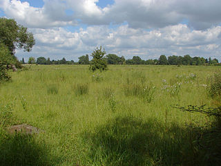
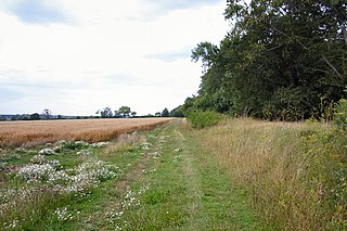
The site is one of the few remaining traditional hay meadows on the coastal plain between the River Tees and the River Tyne and supports a rich variety of species characteristic of this habitat.

Hay dried grass, legumes or other herbaceous plants used as animal fodder

Hay is grass, legumes, or other herbaceous plants that have been cut and dried to be stored for use as animal fodder, particularly for large grazing animals raised as livestock, such as cattle, horses, goats, and sheep. However, it is also fed to smaller domesticated animals such as rabbits and guinea pigs. Even pigs may be fed hay, but they do not digest it as efficiently as herbivores.

River Tees river in northern England

The River Tees is in northern England. It rises on the eastern slope of Cross Fell in the North Pennines, and flows eastwards for 85 miles (137 km) to reach the North Sea between Hartlepool and Redcar near Middlesbrough.

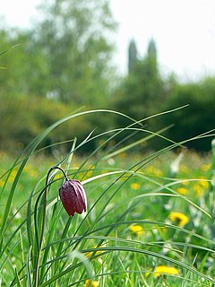
Great burnet, Sanguisorba officinalis , is present in abundance, as are herbs such as sneezewort, Achillea ptarmica , cuckooflower, Cardamine pratensis , meadowsweet, Filipendula ulmaria , and common spotted orchid, Dactylorhiza fuchsii . Grasses include sweet vernal-grass, Anthoxanthum odoratum , common bent, Agrostis capillaris , and downy oat-grass, Avenula pubescens . There are also a notable variety of sedges, including glaucous sedge, Carex flacca , hairy sedge, C. hirta , tawny sedge, C. hostiana , carnation sedge, C. panicea , and flea sedge, C. pulicaris . [1]

<i>Sanguisorba officinalis</i> species of plant

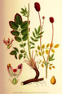
Sanguisorba officinalis, the great burnet, is a plant in the family Rosaceae, subfamily Rosoideae. It is native throughout the cooler regions of the Northern Hemisphere in Europe, northern Asia, and northern North America.

<i>Achillea ptarmica</i> species of plant

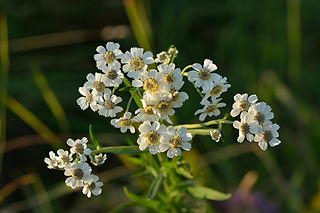
Achillea ptarmica, the sneezewort, sneezeweed, bastard pellitory, European pellitory, fair-maid-of-France, goose tongue, sneezewort yarrow, wild pellitory, or white tansy, is a European species of herbaceous perennial flowering plant in the genus Achillea. It is widespread across most of Europe and naturalized in scattered places in North America.

<i>Cardamine pratensis</i> species of plant

Cardamine pratensis, is a flowering plant in the family Brassicaceae, native throughout most of Europe and Western Asia. The specific name pratensis is Latin for "meadow."

Related Research Articles

Yanal Bog

Yanal Bog is a 1.6 hectare biological Site of Special Scientific Interest on the southern edge of the North Somerset Levels, just north of the village of Sandford, North Somerset. It was notified as an SSSI in 1988.

Plasters Green Meadows

Plaster's Green Meadows is a 4.3 hectare biological Site of Special Scientific Interest near the village of Nempnett Thrubwell, Bath and North East Somerset, notified in 1989.

Bowerchalke Downs

Bowerchalke Downs, is a 128.6 hectare biological Site of Special Scientific Interest in Wiltshire, notified in 1971. The downs encompass the entire southern outlook of the village of Bowerchalke in the Salisbury district of Wiltshire, England, and are adjacent to both the Hampshire and Dorset county boundaries. The Bowerchalke Downs are located within the Cranborne Chase and West Wiltshire Downs Area of Outstanding Natural Beauty and are part of the Southern England Chalk Formation.

North Meadow, Cricklade

North Meadow, Cricklade is a hay meadow near the town of Cricklade, in Wiltshire, England. It is 24.6 hectares in size. It is a traditionally managed lowland hay-meadow, or lammas land, and is grazed in common between 12 August and 12 February each year, and cut for hay no earlier than 1 July. This pattern of land use and management has existed for many centuries and has resulted in the species rich grassland flora and fauna present on the site.

Thorpe Hay Meadow

Thorpe Hay Meadow is a 6.4-hectare (16-acre) biological Site of Special Scientific Interest west of Staines-upon-Thames in Surrey. It is owned and managed by the Surrey Wildlife Trust.

Black Ditches, Cavenham

Black Ditches is an earthwork close to the village of Cavenham of Suffolk, and part of it is a biological Site of Special Scientific Interest (SSSI). The earthwork is 4.5 miles long between the River Lark at Lackford and the Icknield Way. It is described by Historic England as probably of post-Roman date, and "a typical Dark Ages boundary earthwork placed astride the Icknield Way". Two sections of ditch remain visible, one to the north-east of the village and one to the south-east, covering a total of 4.5 miles (7.2 km). An 730 yards (670 m) stretch south of Cavenham is designated as an SSSI.

Far High House Meadows

Far High House Meadows is a Site of Special Scientific Interest in Upper Weardale in west County Durham, England. It consists of three fields, located just south of Burnhope Reservoir, some 3 km west of the village of Ireshopeburn. Two of the fields are maintained as northern hay meadows by traditional farming methods, without re-seeding or the application of artificial fertilisers; the third is grazed as pasture.

Middle Side and Stonygill Meadows

Middle Side and Stonygill Meadows is a Site of Special Scientific Interest in the Teesdale district of County Durham, England. It consists of two separate areas, one to the north of the River Tees, the other on the south bank, about 2 km upstream from the village of Middleton-in-Teesdale. The Park End Wood and Middle Crossthwaite SSSIs lie on the same stretch of floodplain, the Teesdale Allotments SSSI is a short distance to the north, while the higher ground to the south of the river is part of the Upper Teesdale SSSI.

Railway Stell West Site of Special Scientific Interest in the Sedgefield district of County Durham, England

Railway Stell West is a Site of Special Scientific Interest in the Sedgefield district of County Durham, England. The site consists of a length of ditch alongside the East Coast Main Line railway, 3 km east of the town of Newton Aycliffe.

Sherburn Hill (SSSI)

Sherburn Hill is a Site of Special Scientific Interest in County Durham, England. It lies just south of the road between the villages of Sherburn and Sherburn Hill, some 5.5 km east of Durham city. A disused quarry occupies part of the site.

The Bottoms (SSSI)

The Bottoms is a Site of Special Scientific Interest in County Durham, England. It lies just south of the A181 road, roughly midway between the villages of Cassop and Wheatley Hill, some 10 km south-east of Durham city.

Chaceley Meadow SSSI

Chaceley Meadow is a 1.8-hectare (4.4-acre) biological Site of Special Scientific Interest in Gloucestershire, notified in 1954 and renotified in 1993. It lies on the eastern edge of Chaceley village and is about half a mile west of the River Severn.

Upham Meadow and Summer Leasow

Upham Meadow and Summer Leasow is a 104.0-hectare (257-acre) biological Site of Special Scientific Interest on the border between Gloucestershire and Herefordshire & Worcestershire, at Twyning and near Bredon, notified in 1991.

Yarley Meadows

Yarley Meadows is a 12.2-hectare (30-acre) biological Site of Special Scientific Interest in Gloucestershire, England, notified in 1987.

Allendale Moors

Allendale Moors is a Site of Special Scientific Interest (SSSI) in Northumberland, England. The upland moorland ridge site is listed for its heath, flush and upland grassland which provide a habitat for a nationally important assemblage of moorland breeding birds.

Allolee to Walltown

Allolee to Walltown is the name given to a Site of Special Scientific Interest (SSSI) in Northumberland, England. The site, which follows the path of a section of Hadrian's Wall, is notable for an unusually wide range of grassland types growing on thin soil above the Whin Sill, a rock formation peculiar to the Northern Pennines.

Aules Hill Meadows

Aules Hill Meadows is the name given to a Site of Special Scientific Interest (SSSI) in Northumberland, England. The site, listed since 1992, is a set of four traditionally managed northern hay meadows, now rare in Northumberland.

Barrow Burn Meadows Site of Special Scientific Interest in England

Barrow Burn Meadows is the name given to a Site of Special Scientific Interest (SSSI) in north Northumberland, England. The site is a species-rich hay meadow of a sort now rare in Northumberland.

Ashford Hill is a British national nature reserve next to the village of Ashford Hill in Hampshire. Part of the reserve is a designated a Site of Special Scientific Interest (SSSI). The site is one of Natural Englands nature reserves

Ron Ward's Meadow With Tadley Pastures is a site of Site of Special Scientific Interest (SSSI). It is based on the edge of Tadley in Hampshire. It is managed by the Hampshire and Isle of Wight Wildlife Trust.

References

  1. "Newton Ketton Meadow" (PDF). English Nature. 1989. Retrieved 29 July 2010.