Chatham Parish, New Brunswick

Last updated

Chatham
Northumberland County NB - Chatham Parish.PNG
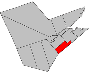
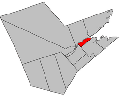
Location within Northumberland County, New Brunswick
Coordinates: 47°02′42″N65°22′12″W / 47.045°N 65.37°W / 47.045; -65.37
Country Flag of Canada (Pantone).svg  Canada
Province Flag of New Brunswick.svg  New Brunswick
County Northumberland
Erected1814
Area
[1]
  Land22.70 km2 (8.76 sq mi)
Population
 (2021) [1]
  Total527
  Density23.2/km2 (60/sq mi)
  Change 2016-2021
Increase2.svg 3.1%
  Dwellings
269
Time zone UTC-4 (AST)
  Summer (DST) UTC-3 (ADT)
Figures do not include portion within the city of Miramichi

Chatham is a geographic parish in Northumberland County, New Brunswick, Canada. [4]

Contents

For governance purposes it is divided between the city of Miramichi [5] and the Greater Miramichi rural district, [6] both of which are members of the Greater Miramichi Regional Service Commission. [7]

Prior to the 2023 governance reform, all of the parish outside the city formed the local service district of the parish of Chatham. [8]

Origin of name

The parish was named in honour of the Earl of Chatham, a title held at the time by General John Pitt, or for his father, former British Prime Minister Pitt the Elder. [9]

The Provincial Archives of New Brunswick gives British Prime Minister Pitt the Younger as the inspiration of the name, but erroneously gives him the title of Earl of Chatham, which he never held. [10] He died in office in 1806.

Six of the nine Northumberland County parishes erected simultaneously in 1814 [11] were named for military figures of the Napoleonic Wars or British politicians associated with the military.

The strongest case might be for the parish's eponym might be General Pitt, who was Master-General of the Ordnance for most of the Napoleonic Wars and closely involved with planning Britain's coastal defenses. General Pitt was influential enough to be offered the Portugal command that later went to Arthur Wellesley, 1st Duke of Wellington.

History

Chatham was erected in 1814 from Newcastle Parish [11] but did not include the modern Douglasfield and Chatham Head areas, which were in neighbouring Nelson Parish until 1850. [12]

Boundaries

Chatham Parish is bounded: [2] [13] [14]

Evolution of boundaries

In 1814 the western line was about 300 metres west of Harper Road, along the western line of a grant to William McCallum and its prolongation inland. [11] The southern boundary ran eight miles up the River from its mouth, "or until it intersects the before mentioned line [...] forming the rear of the said Parishes of Wellington and Carleton". [lower-alpha 2] If the line continues along the Northwest Branch rather than the main body of the river then eight miles from the mouth of the Napan is roughly where the prolongation of the McCallum grant strikes the Napan.

In 1850 the parish was extended west to its modern boundary and the southern boundary was altered slightly, establishing the modern boundaries. [12] Several pieces of territory on either side of the river were exchanged with Glenelg.

Communities

Communities at least partly within the parish. [13] [14] [17] bold indicates an incorporated municipality

Bodies of water

Bodies of water [lower-alpha 3] at least partly within the parish. [13] [14] [17]

Islands

Islands at least partly within the parish. [13] [14] [17]

Other notable places

Parks, historic sites, and other noteworthy places at least partly within the parish. [13] [14] [17]

Demographics

Parish population total does not include portion within 2021 boundaries of Miramichi. Revised census figures based on the 2023 local governance reforms have not been released.

See also

Notes

  1. By the magnet of 1850, [12] when declination in the area was between 20º and 21º west of north. [15] The Territorial Division Act clause referring to magnetic direction bearings was omitted in the 1952 [16] and 1973 Revised Statutes. [2]
  2. Uses of long s in the text have been modernised for readability.
  3. Not including brooks, ponds or coves.

Related Research Articles

<span class="mw-page-title-main">Moncton Parish, New Brunswick</span> Parish in New Brunswick, Canada

Moncton is a geographic parish in Westmorland County, New Brunswick, Canada.

<span class="mw-page-title-main">Alnwick Parish, New Brunswick</span> Parish in New Brunswick, Canada

Alnwick is a geographic parish in Northumberland County, New Brunswick, Canada.

<span class="mw-page-title-main">Hardwicke Parish, New Brunswick</span> Parish in New Brunswick, Canada

Hardwicke is a geographic parish in Northumberland County, New Brunswick, Canada.

<span class="mw-page-title-main">Ludlow Parish, New Brunswick</span> Parish in New Brunswick, Canada

Ludlow is a geographic parish in Northumberland County, New Brunswick, Canada.

<span class="mw-page-title-main">Saint-Joseph Parish, New Brunswick</span> Parish in New Brunswick, Canada

Saint-Joseph is a geographic parish in Madawaska County, New Brunswick, Canada.

<span class="mw-page-title-main">Saint-Basile Parish, New Brunswick</span> Parish in New Brunswick, Canada

Saint-Basile is a geographic parish in Madawaska County, New Brunswick, Canada.

<span class="mw-page-title-main">Newcastle Parish, New Brunswick</span> Parish in New Brunswick, Canada

Newcastle is a geographic parish in Northumberland County, New Brunswick, Canada.

<span class="mw-page-title-main">Northesk Parish, New Brunswick</span> Parish in New Brunswick, Canada

Northesk is a geographic parish in Northumberland County, New Brunswick, Canada.

<span class="mw-page-title-main">Southesk Parish, New Brunswick</span> Parish in New Brunswick, Canada

Southesk is a geographic parish in Northumberland County, New Brunswick, Canada.

<span class="mw-page-title-main">Derby Parish, New Brunswick</span> Parish in New Brunswick, Canada

Derby is a geographic parish in Northumberland County, New Brunswick, Canada.

<span class="mw-page-title-main">Nelson Parish, New Brunswick</span> Parish in New Brunswick, Canada

Nelson is a geographic parish in Northumberland County, New Brunswick, Canada.

<span class="mw-page-title-main">Glenelg Parish, New Brunswick</span> Parish in New Brunswick, Canada

Glenelg is a geographic parish in Northumberland County, New Brunswick, Canada.

<span class="mw-page-title-main">Rogersville Parish, New Brunswick</span> Parish in New Brunswick, Canada

Rogersville is a geographic parish in Northumberland County, New Brunswick, Canada.

<span class="mw-page-title-main">Blackville Parish, New Brunswick</span> Parish in New Brunswick, Canada

Blackville is a geographic parish in Northumberland County, New Brunswick, Canada.

<span class="mw-page-title-main">Carleton Parish, New Brunswick</span> Parish in New Brunswick, Canada

Carleton is a geographic parish in Kent County, New Brunswick, Canada.

<span class="mw-page-title-main">Stanley Parish, New Brunswick</span> Parish in New Brunswick, Canada

Stanley is a geographic parish in York County, New Brunswick, Canada.

<span class="mw-page-title-main">Shediac Parish, New Brunswick</span> Parish in New Brunswick, Canada

Shediac is a geographic parish in Westmorland County, New Brunswick, Canada.

<span class="mw-page-title-main">Sheffield Parish, New Brunswick</span> Parish in New Brunswick, Canada

Sheffield is a geographic parish in Sunbury County, New Brunswick, Canada.

<span class="mw-page-title-main">Saint George Parish, New Brunswick</span> Parish in Canada

Saint George is a geographic parish in Charlotte County, New Brunswick, Canada, located between St. Stephen and Saint John.

<span class="mw-page-title-main">Saint Patrick Parish, New Brunswick</span> Parish in Canada

Saint Patrick is a geographic parish in Charlotte County, New Brunswick, Canada, located west of St. George and Saint Andrews.

References

  1. 1 2 "Census Profile". Statistics Canada. 26 October 2022. Retrieved 29 October 2022.
  2. 1 2 3 "Chapter T-3 Territorial Division Act". Government of New Brunswick. Retrieved 13 February 2023.
  3. "Chapter I-13 Interpretation Act". Government of New Brunswick. Retrieved 13 February 2023.
  4. The Territorial Division Act [2] divides the province into 152 parishes, the cities of Saint John and Fredericton, and one town of Grand Falls. The Interpretation Act [3] clarifies that parishes include any local government within their borders.
  5. "Greater Miramichi Regional Service Commission: RSC 5". Government of New Brunswick. Retrieved 13 February 2023.
  6. "Greater Miramichi Regional Service Commission: RD 5". Government of New Brunswick. Retrieved 13 February 2023.
  7. "Regions Regulation – Regional Service Delivery Act". Government of New Brunswick. 21 July 2022. Retrieved 13 February 2023.
  8. "Local Service Districts Regulation - Municipalities Act". Government of New Brunswick. 25 June 2021. Retrieved 13 February 2023.
  9. Ganong, William F. (1896). A Monograph of the Place-Nomenclature of the Province of New Brunswick. Royal Society of Canada. p. 226. Retrieved 17 March 2021.
  10. "Chatham Parish". Provincial Archives of New Brunswick. Retrieved 27 March 2021.
  11. 1 2 3 "54 Geo. III c. 17 An Act in further addition to an Act, intituled 'An Act for the better ascertaining and confirming the boundaries of the several Counties, within this Province, and for subdividing them into Towns or Parishes.'". Acts of the General Assembly of His Majesty's Province of New-Brunswick; Passed in the Year 1814. Saint John, New Brunswick: Government of New Brunswick. 1814. pp. 16–18. Retrieved 20 March 2021.
  12. 1 2 3 "13 Vic. c. 51 An Act to consolidate all the Laws now in force for the division of the Province into Counties, Towns and Parishes.". Acts of the General Assembly of Her Mjaesty's Province of New Brunswick, Passed in the Year 1850. Fredericton: Government of New Brunswick. 1850. pp. 142–152, 145–149. Retrieved 20 March 2021. Book was poorly proofread, resulting in title typo and reuse of page numbers 145–152.
  13. 1 2 3 4 5 "No. 60". Provincial Archives of New Brunswick. Department of Natural Resources and Energy Development. Retrieved 18 June 2021. Remainder of parish on maps 61, 69, and 70 at same site.
  14. 1 2 3 4 5 "189" (PDF). Transportation and Infrastructure. Government of New Brunswick. Retrieved 18 June 2021. Remainder of parish on mapbooks 190 and 204 at same site.
  15. "Historical Magnetic Declination". National Oceanic and Atmospheric Administration. Retrieved 14 March 2021.
  16. "Chapter 227 Territorial Division Act". The Revised Statutes of New Brunswick 1952 Volume III. Fredericton: Government of New Brunswick. 1952. pp. 3725–3771.
  17. 1 2 3 4 "Search the Canadian Geographical Names Database (CGNDB)". Government of Canada. Retrieved 6 July 2021.
  18. Statistics Canada: 1996, 2001, 2006 census
  19. 2006 Statistics Canada Community Profile: Chatham Parish, New Brunswick
  20. 2011 Statistics Canada Census Profile: Chatham Parish, New Brunswick
  21. 1 2 "Census Profile, 2016 Census Chatham, Parish [Census subdivision], New Brunswick". Statistics Canada. Retrieved 26 September 2019.


47°02′42″N65°22′12″W / 47.04500°N 65.37000°W / 47.04500; -65.37000 (Chatham Parish, New Brunswick)