Chinnakada

Last updated

Chinnakada
Chinnakkada
Chinnakada Collage, May 2020.jpg
Location map India Kollam EN.svg
Red pog.svg
Chinnakada
Location in Kollam, India
India Kerala location map.svg
Red pog.svg
Chinnakada
Chinnakada (Kerala)
Coordinates: 8°53′13″N76°35′28″E / 8.887°N 76.591°E / 8.887; 76.591
CountryFlag of India.svg  India
State Kerala
District Kollam
Government
  Body Kollam Municipal Corporation(KMC)
Languages
  Official Malayalam, English
Time zone UTC+5:30 (IST)
PIN
691001
Vehicle registration KL-02
Lok Sabha constituency Kollam
Civic agency Kollam Municipal Corporation
Avg. summer temperature34 °C (93 °F)
Avg. winter temperature22 °C (72 °F)
Website http://www.kollam.nic.in

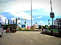
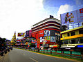
Chinnakada or Chinnakkada is considered as the heart of the city of Kollam in Kerala, India. Chinnakada is a busy junction where 5 city roads and one National highway interconnect at a traffic roundabout. The city's symbolic clock tower is located in Chinnakada. To reduce the traffic congestion in Chinnakada, Kollam Municipal Corporation constructed an underpass near to clock tower. [1] Marine Products Export Development Authority (MPEDA)'s Kollam sub-regional office is situated at Chinnakada. [2]

Contents

Toponymy

The name Chinnakada may be derived from China-Kada, which means China bazaar. Chinese coins and other artefacts in enormous quantities were found near the Kollam port, proving Kollam was a significant Chinese trading hub. [3] Another explanation is that due to the presence of a large number of Tamil people in Kollam, they named the area Chinnakada, which means "small market" in the Tamil language. This derivation fits with the toponomy of Valiakada adjacent to Chinnakada, which means "big market" in Malayalam. [4]

Other areas in Kollam ending with the word kada in the name

History

The ancient city of Kollam, then known as Quilon, was an important center for trade with the Chinese. [5]

The Chinese traders were one of the oldest foreign communities to settle in Kollam. That was during 8th century AD or even before. That was during the period Kollam evolved as a major trade centre ( of spices ) and an important port in the Malabar coast. Chinnakada could be the corrupted form of China-Kada , means China Bazaar ( or Chinese market). That argument should be taken with a pinch of salt , as Chinnakkada also means small market (in Tamil). That stands complementary to the Valiakada adjacent to Chinnakada, which means big market in Malayalam. [6]

Chinnakada Underpass

Aerial view of Chinnakada in 2008 Arial view of Chinnakada in 2008.jpg
Aerial view of Chinnakada in 2008

The Chinnakada Underpass is a public road infrastructure project for the city of Kollam as part of the Kerala Sustainable Urban Development Project supported by the Asian Development Bank (ADB) to ease traffic congestion at Chinnakada, the city CBD of Kollam. [7] The presence of an existing Railway over bridge and three close intersections with heavy traffic limits the option for traffic management measures including junction improvement. That caused the authorities to think about this underpass at Chinnakada. Chinnakada is a complex junction where roads from Thiruvananthapuram, Alappuzha, Downtown, Sengottai, Ashramam, Kollam Beach and the City bus stand road meets.

Preliminary design for underpass was prepared by NATPAC (NATPAC - National Transportation Planning and Research Centre) [8] involving the acquisition of 0.08 hectares (0.20 acres) of government land on a temporary basis. [9] Height of the road passage above the underpass was increased to 5.5 metres (18 ft) from 5 metres (16 ft) to facilitate movement of modern container trucks through the underpass. Underpass has been thrown open to the public by the end of May 2015. [10] [11]

Chinnakada Panorama, Sep 2015.jpg
Panorama of Chinnakada, the CBD of Kollam (Quilon) city in India in September 2015

See also

Related Research Articles

National Highway 744 or NH 744 is a National Highway in Southern India that links Kollam (Quilon) in Kerala with Madurai in Tamil Nadu. Starting from NH 66 at Chinnakkada in Kollam, it joins Tirumangalam in Madurai at National Highway 44 (India).

Kureepuzha is a peninsula region in the city of Kollam, Kerala, India, located on the shore of Ashtamudi Lake. Kureepuzha is sharing borders with the village of Neeravil in the north. It is one among the 55 councils of Kollam Municipal Corporation(KMC). Kerala's only turkey farm and a regional poultry farm are at Kureepuazha. Kollam city's waste management plant is also situated at Kureepuzha.

<span class="mw-page-title-main">Kollam Municipal Corporation</span> Local civic body in Kollam, Kerala, India

Kollam Municipal Corporation (KMC) is an ISO 9001:2015 certified civic body that governs the city of Kollam in the Indian state of Kerala. It is the fourth-largest city corporation by population in the state, and the fifth-largest by area. Constituted in 1903 it was officially recognized as a city corporation in 2000. The body governs an area of 73.03 square kilometres (28.20 sq mi) centered at Kollam, with about 55 divisions and a population of 397,419.

<span class="mw-page-title-main">Kadappakada</span> Neighbourhood in Kollam, Kerala, India

Kadappakada or Kadappakkada is a neighbourhood and important junction in the city of Kollam, in the state of Kerala, India. NH 744, that connects Kollam with Tirumangalam meets the Asramam Link Road at Kadappakada junction. Most of the times the authorities are diverting the traffic in National Highways through the Link road, if required.

<span class="mw-page-title-main">Andamukkam City bus stand</span>

Andamukkam City bus stand, Kollam, is one of the two bus stands in the city of Kollam in the Indian state of Kerala. Situated in the Downtown Kollam area, it is also known as Andamukkam private bus stand. The bus stand is only for private city buses and Kerala State Road Transport Corporation (KSRTC) ordinary bus services running to Chinnakada. It is the starting point of various city bus services connecting Chinnakada to Mayyanad, Elampalloor, Sakthikulangara, Chavara, Thoppilkadavu, Prakkulam, Kottiyam, Perumon and Kadavoor. KSRTC have plans to start an operations centre at the bus station.

<span class="mw-page-title-main">Kollam Development Authority</span>

Kollam Development Authority (KDA) was an autonomous statutory body overseeing the development of the City of Kollam in the state of Kerala, India. KDA was the responsible body for the planning and development of the major parts of Kollam urban area which consists of the City corporation of Kollam and its surrounding areas like Eravipuram, Sakthikulangara, Neendakara, Uliyakovil, Anchalumoodu, Kottiyam etc. KDA was one of the 5 significant city development authorities in Kerala which gained in significance because of the importance of the City of Kollam as the emerging 'Port City of Kerala'.

<span class="mw-page-title-main">Mundakkal</span> Neighbourhood in Kollam, Kerala, India

Mundakkal, also spelt Mundackal, is an important residential area and industrial hub situated in the city of Kollam, Kerala, India. The place is considered as the capital of India's cashew processing activities. Kerala State Cashew Development Corporation Limited(KSCDC) and Cashew Export Promotion Council of India(CEPCI) are headquartered at Mundakkal in Kollam city. It is an important tourist place in the city and a part of Downtown Kollam which gained in significance because of the presence of a flourishing beach. During 'Karkidaka Vavubali', thousands of devotees arrive on the beach to perform the Vavubali Tharpanam. Vavubali is an important ritual observed by Hindus in Kerala in the month of Karkidakam. The ritual involves people offering Bali to the departed souls. The ritual is performed by men, women, and children.

Maruthadi or Maruthady is a coastal town situated in the city of Kollam, Kerala, India. The place is very famous in the state for its fishing activities. The presence of Kattaka Kayal, a two-km long stream that once served as the lifeline for most of the commercial activities at Sakthikulangara and the 36-acre Vattakayal are making Maruthadi an important tourism spot in the city.

<span class="mw-page-title-main">Polayathode</span> Neighbourhood in Kollam, Kerala, India

Polayathode or Polayathodu is one of the fastest growing neighbourhoods of the city of Kollam, in the state of Kerala, India. It is situated at National Highways – NH 66. Kerala Police have identified Polayathode as one of the traffic black spots in the state.

<span class="mw-page-title-main">Kilikollur</span> Zone & Neighbourhood in Kollam, Kerala, India

Kilikolloor, also known as Kilikollur, is a neighbourhood in Kollam district in Kerala, India. It is a center of the cashew industry in the area, and is also a hub of automobile production.

<span class="mw-page-title-main">Downtown Kollam</span>

Downtown Kollam is the primary central business district in the city of Kollam, Kerala, India. Located entirely within the former municipality of old Quilon, it is approximately bounded by Chinnakada to the east, Thangassery to the West, Cutchery to the north, and Mundakkal to the South. The area is popularly known for its business activities. Kollam was formerly an international emporium of trade and today remains a prosperous commercial centre.

<span class="mw-page-title-main">Asramam Link Road</span>

The Asramam Link Road is an important four-lane city road in Kollam in the Indian state of Kerala. This road was formerly known as Airport Road or Aerodrome Road as it was the connection road to Kollam Airport, the one and only airport in the entire Kerala coast then. The road starts from Kappalandimukku near Polayathode in the east and currently ends at KSRTC, but is ultimately planned to extend to Thoppilkadavu in the west of the city. The Rs.114 crore worth third phase of construction includes a 3 km long flyover, which would extend it from Kollam KSRTC Bus Station to Thoppilkadavu, is going on now.

<span class="mw-page-title-main">Asramam</span> Neighbourhood in Kollam, Kerala, India

Asramam or Ashramam is one of the prime locations in Kollam city of Kerala, India. It is one among the 55 wards of Kollam Municipal Corporation. Asramam is a notable place in the city because of the presence of old airport, public/private institutions, tourism destinations, parks, hospitals, maidan etc. Asramam Maidan, the biggest open space now existing in any of the Kerala Municipal Corporation limits is situated at Asramam. The first airport in the state of Kerala, Kollam Airport, was functioned in this maidan. Asramam is the headquarters of the Kollam branches of Indian Medical Association and Sports Authority of India. Link Road, one of the important roads in the city, passing through Asramam. The one and only International Hockey Stadium in the state is at Asramam. srenarayana open university asramam walk way around the asramam ground

<span class="mw-page-title-main">Chinnakada Clock Tower</span>

Chinnakada Clock Tower is a landmark in Kollam City in the Indian state of Kerala. In Chinnakada, the tower lies in the heart of the city, close to Kollam Junction Railway Station. As the first clock tower in the erstwhile Travancore state, it has become a non-official emblem of the city and the major landmark of Kollam.

<span class="mw-page-title-main">Andamukkam</span> Neighbourhood in Kollam, Kerala, India

Andamukkam or Aandamukkam is a neighbourhood of Kollam city in Kerala, India. It is a part of Downtown Kollam. Andamukkam is one of the prime commercial centres of Kollam city, which was once the most important port city of India. The city bus stand in Kollam is in Andamukkam. Proximity of Andamukkam with other neighbourhoods of Kollam is making it a prime commercial centre and transportation hub of the city.

<span class="mw-page-title-main">Chamakada</span> Neighbourhood in Kollam, Kerala, India

Chamakada or Chamakkada is one of the trade hubs of the city of Kollam, India. It is an important neighbourhood in the city and is located at the core Downtown Kollam area. The area is very famous for wholesale dealers and rice merchants. The local retail dealers are filling the stocks regularly from Chamakada-based wholesale dealers. So many bank branches, godowns, store rooms, printing presses, automobile spare parts stores, courier services etc. are located at Chamakada area. Chamakada is the second main commercial centre of Kollam city after Chinnakada. So many famous restaurants also located at Chamakada.

<span class="mw-page-title-main">Thoppilkadavu</span> Neighbourhood in Kollam, Kerala, India

Thoppilkadavu or Thoppilkkadavu is one of the neighbourhoods of the city of Kollam, located on the shores of Ashtamudi Lake in Kerala, India. It is an integral part of Kollam city. Presence of Ashtamudi Lake is increasing the importance of Thoppilkadavu as one of the tourism hotspots in the city. Thoppilkadavu is the western endpoint of Asramam Link Road in the city.

<span class="mw-page-title-main">Cutchery</span> Neighbourhood in Kollam, Kerala, India

Cutchery or Taluk Cutchery or Taluk Kacheri is a neighbourhood of the city of Kollam. It is the 49th ward in Kollam Municipal Corporation. The place got the name Cutchery from a similar word in Malayalam: കച്ചേരി which means office/court. Kollam Taluk office is situated at Cutchery.

<span class="mw-page-title-main">Transport in Kollam</span>

Transport in Kollam includes various modes of road, rail and water transportation in the city and its suburbs. State-owned Kerala State Road Transport Corporation buses, private buses, Indian Railways, state-owned Kerala State Water Transport Department boats & ferry, taxis and auto rickshaws are serving the city of Kollam. The city had a strong commercial reputation since the days of the Phoenicians and Romans. Ibn Battuta mentioned Kollam Port as one of the five Indian ports he had seen during the course of his twenty-four year travels.

References

  1. "It's traffic nightmare in Kollam as underpass work resumes". The Times of India. 15 May 2014. Retrieved 18 May 2018.
  2. "MPEDA". Archived from the original on 26 January 2015. Retrieved 9 February 2015.
  3. "Allusions and Artifacts of Chinese Trade from Kollam, South Kerala, India". Research Gate.
  4. "History of Kollam - Everything about Kerala!". Archived from the original on 2 June 2015. Retrieved 5 November 2015. History of Kollam
  5. Archived 2 January 2014 at the Wayback Machine Short History - Kollam
  6. "History of Kollam" . Retrieved 23 July 2023.
  7. Chinnakada underpass: dispute settled
  8. "NATPAC" . Retrieved 9 February 2017.
  9. "ADB Resettlement Planning Document - Chinnakada underpass" (PDF). Archived from the original (PDF) on 14 July 2014. Retrieved 23 June 2014.
  10. Chinnakada underpass work to be over by September
  11. "Traffic remains messy at Chinnakada - The Hindu". The Hindu . 3 June 2015. Retrieved 4 June 2015.