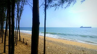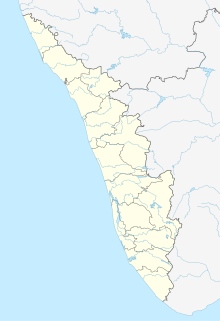
Kollampronunciation (help·info), known by its former name Quilonpronunciation (help·info) and Koolam, Coulão, and Desinganadu, is an ancient seaport and city on the Malabar Coast of India bordering the Laccadive Sea, which is a part of the Arabian Sea. It is situated 66 kilometers north of the state capital Trivandrum. The city is on the banks of Ashtamudi Lake and the Kallada river.
Kollam district is one of 14 districts of the state of Kerala, India. The district has a cross-section of Kerala's natural attributes; it is endowed with a long coastline, a major Laccadive Sea seaport and an inland lake. The district has many water bodies. Kallada River is one among them, and the east side land of river is East Kallada and the west side land is West Kallada.

Anchalumoodu is a town and neighbourhood of the city of Kollam, India. It is a historic town near the place, where the Peruman railway accident happened in 1988. Anchalumoodu is 8 km away from Kollam city, 26 km from Paravur and 8 km from Kundara town. College of Engineering, Perumon is very close to this place. Anchalumoodu was a part of Thrikkadavoor till 2015. In May 2015, Government of Kerala have decided to expand City Corporation of Kollam by merging Thrikkadavoor panchayath. Now Anchalumoodu along with Thrikkadavoor is a part of Kollam city.

Eravipuram is a Neighbourhood of the city of Kollam in Kerala, India. It is one among the 6 zones of the Kollam City Corporation. Other zones of the city of Kollam are Central Zone-I, Central Zone-II, Sakthikulangara, Kilikollur and Vadakkevila.

Chandanathope is a town located in the city of Kollam, Kerala. It lies 23 kilometres (14 mi) from Paravur town and 8 kilometres (5.0 mi) from Kollam city centre on the Kollam–Thirumangalam National Highway 744. In Malayalam, the name denotes a place with sandalwood plantations. It is also known for cashew processing and its exports two major cashew exporters of Kollam namely VLC Cashews and MARK has their facilities in the town.

Kollam Municipal Corporation (KMC) is an ISO 9001:2015 certified civic body that governs the city of Kollam in the Indian state of Kerala. It is the fourth-largest city corporation by population in the state, and the fifth-largest by area. Constituted in 1903 it was officially recognized as a city corporation in 2000. The body governs an area of 73.03 square kilometres (28.20 sq mi) centered at Kollam, with about 55 divisions and a population of 397,419.

Kollam metropolitan area is the 14th largest urban agglomeration in South India and 7th largest in Kerala. It is one of the 10 fastest growing cities in the world covering an area of 364.51 km2 (2015) with a 31.1% urban growth between 2015 and 2020 as per the survey conducted by Economist Intelligence Unit (EIU) based on urban area growth during January 2020.

Mundakkal, also spelled Mundackal, is an important residential area and industrial hub situated in the city of Kollam, Kerala, India. The place is considered as the capital of India's cashew processing activities. Kerala State Cashew Development Corporation Limited(KSCDC) and Cashew Export Promotion Council of India(CEPCI) are headquartered at Mundakkal in Kollam city. It is an important tourist place in the city and a part of Downtown Kollam which gained in significance because of the presence of a flourishing beach. During 'Karkidaka Vavubali', thousands of devotees arrive on the beach to perform the Vavubali Tharpanam. Vavubali is an important ritual observed by Hindus in Kerala in the month of Karkidakam. The ritual involves people offering Bali to the departed souls. The ritual is performed by men, women, and children.

Maruthadi or Maruthady is a coastal town situated in the city of Kollam, Kerala, India. The place is very famous in the state for its fishing activities. The presence of Kattaka Kayal, a two-km long stream that once served as the lifeline for most of the commercial activities at Sakthikulangara and the 36-acre Vattakayal are making Maruthadi an important tourism spot in the city.

Killikolloor, also known as Killikollur, is a neighbourhood in Kollam in Kerala, India. It is a center of the cashew industry in the area, and is also a hub of automobile production.

The Asramam Link Road is an important four-lane city road in Kollam in the Indian state of Kerala. This road was formerly known as Airport Road or Aerodrome Road as it was the connection road to Kollam Airport, the one and only airport in the entire Kerala coast then. The road starts from Kappalandimukku near Polayathode in the east and currently ends at KSRTC, but is ultimately planned to extend to Thoppilkadavu in the west of the city. The Rs.114 crore worth third phase of construction includes a 3 km long flyover, which would extend it from Kollam KSRTC Bus Station to Thoppilkadavu, is going on now.

Thattamala is a neighbourhood situated at the southeast border of Kollam city in state of Kerala, India. It is situated at National Highways – NH 66. Kerala Police have identified Thattamala as one of the traffic black spots in the state.

Pallithottam is a neighbourhood of Kollam city situated at the coastal region. It is the 46th ward in Kollam Municipal Corporation. Pallithottam is totally depending on fishing activities and operations of Kollam Port.

Transport in Kollam includes various modes of road, rail and water transportation in the city and its suburbs. State-owned Kerala State Road Transport Corporation buses, private buses, Indian Railways, state-owned Kerala State Water Transport Department boats & ferry, taxis and auto rickshaws are serving the city of Kollam. The city had a strong commercial reputation since the days of the Phoenicians and Romans. Ibn Battuta mentioned Kollam Port as one of the five Indian ports he had seen during the course of his twenty-four year travels.

Mulamkadakam or Mulangadakam/Mulamkadakom is a neighbourhood of Kollam (Quilon) city, India. It is situated at the northern region of the city. Mulamkadakam is the 7th ward of Kollam Municipal Corporation which is in Sakthikulangara zone of the city. Devi temple at Mulamkadakam is famous in the state. Kerala University's University Institute of Technology centre is situated at Mulamkadakam.

Uliyakovil or Uliyakkovil is a thickly populated neighbourhood of the city of Kollam, India. It is the 11th ward in Kollam Municipal Corporation, Kerala. Uliyakovil is one of the major contributors to the city's seafood exports.There is a publication house also.

Koottikkada or Koottikada is a small neighbourhood of the city of Kollam. It is the 29th ward in Kollam Municipal Corporation. Koottikkada is a thickly populated area in the city. Kollam-Thiruvananthapuram railway line is passing through Koottikada. So many mosques and temples are there in this area.
Kollam district, earlier called Quilon district, is one of the 14 districts of Kerala state, India. The district is representative of all the natural attributes of Kerala states, and is endowed with a long coastal region, a major sea port on the Arabian Sea, plains and the mountains, lakes, lagoons and Kerala Backwaters, forests and the farm land, and rivers and streams. The area had mercantile relationship with Phoenicians and the Romans.
Kollam District has four types of administrative hierarchies:


