Kadappakada Kadappakkada | |
|---|---|
Neighbourhood | |
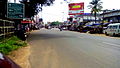
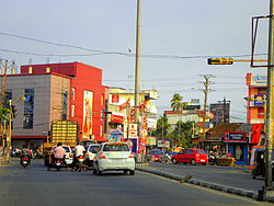 Kadappakkada Junction, Kollam | |
 Kadappakada Location in Kollam, India  Kadappakada Kadappakada (Kerala)  Kadappakada Kadappakada (India) | |
| Coordinates: 8°53′32″N76°36′13″E / 8.892283°N 76.603591°E | |
| Country | |
| State | Kerala |
| District | Kollam |
| Government | |
| • Body | Kollam Municipal Corporation(KMC) |
| Languages | |
| • Official | Malayalam, English |
| Time zone | UTC+5:30 (IST) |
| PIN | 691008 |
| Vehicle registration | KL-02 |
| Lok Sabha constituency | Kollam |
| Civic agency | Kollam Municipal Corporation |
| Avg. summer temperature | 34 °C (93 °F) |
| Avg. winter temperature | 22 °C (72 °F) |
| Website | http://www.kollam.nic.in |
Kadappakada or Kadappakkada is a neighbourhood and important junction in the city of Kollam, in the state of Kerala, India. NH 744 (Earlier NH 208), that connects Kollam with Tirumangalam meets the Asramam Link Road at Kadappakada junction. Usually the authorities divert the traffic in National Highways through the Link road, if required. [1]