Fort Pillow State Historic Park is a state park in western Tennessee that preserves the American Civil War site of the Battle of Fort Pillow. The 1,642 acre (6.6 km²) Fort Pillow, located in Lauderdale County on the Chickasaw Bluffs overlooking the Mississippi River, is rich in both historic and archaeological significance. In 1861, the Confederate army built extensive fortifications and named the site for General Gideon Johnson Pillow of Maury County. It was attacked and held by the Union Army for most of the American Civil War period except immediately after the Battle of Fort Pillow, when it was retaken by the Confederate Army. Many African-American soldiers were killed in what modern historians describe as a "massacre" or "atrocity". Interpretive sites are part of the park.

Patterson is an unincorporated community in Wayne County, Missouri, United States. It is located about seven miles east of Piedmont on Route 34.

Columbus-Belmont State Park, on the shores of the Mississippi River in Hickman County, near Columbus, Kentucky, is the site of a Confederate fortification built during the American Civil War. The site was considered by both North and South to be strategically significant in gaining and keeping control of the Mississippi River. It commemorates military actions that took place in both Columbus, Kentucky, and Belmont, Missouri across the river.

The Bollinger Mill State Historic Site is a state-owned property preserving a mill and covered bridge that pre-date the American Civil War in Burfordville, Cape Girardeau County, Missouri. The park was established in 1967 and offers mill tours and picnicking. It is managed by the Missouri Department of Natural Resources. It includes the Burfordville Covered Bridge, which is listed on the National Register of Historic Places.

Fort O'Brien State Historic Site, also known as Fort Machias, preserves the remains of a fort located in Machiasport, Maine that was built and destroyed three times over a 90-year period. It was involved in military actions during the American Revolutionary War and the War of 1812, and was listed on the National Register of Historic Places. It is now managed by the Maine Department of Conservation's Bureau of Parks and Lands, and is open between Memorial Day and Labor Day.

Graham Cave is a Native American archeological site near Mineola, Missouri in Montgomery County in the hills above the Loutre River. It is located in the 356 acre Graham Cave State Park. The entrance of the sandstone cave forms a broad arch 120 feet (37 m) wide and 16 feet (5 m) high. Extending about 100 feet (30 m) into the hillside, the cave protects an historically important Pre-Columbian archaeological site from the ancient Dalton and Archaic period dating back to as early as 10,000 years ago.

Fort Lee is a historic American Revolutionary War fort in Salem, Massachusetts. The site, located at a high point next to Fort Avenue on Salem Neck, is a relatively rare fortification from that period whose remains are relatively unaltered. Although there is some documentary evidence that the Neck was fortified as early as the 17th century, the earthworks built in 1776 are the first clear evidence of the site's military use. The site, of which only overgrown earthworks survive, was repaired at the time of the War of 1812 and the American Civil War, but was not substantially modified in those times, or overbuilt with more modern fortifications.

Fort Pickering is a 17th-century historic fort site on Winter Island in Salem, Massachusetts. Fort Pickering operated as a strategic coastal defense and military barracks for Salem Harbor during a variety of periods, serving as a fortification from the Anglo-Dutch Wars through World War II. Construction of the original fort began in 1643 and it saw use as a military installation into the 20th century. Fort Pickering is a First System fortification named for Colonel Timothy Pickering, adjutant general of the Continental Army and secretary of War in 1795. Today, the remains of the fort are open to the public as part of the Winter Island Maritime Park, operated by the City of Salem.

Fort Sewall is a historic coastal fortification in Marblehead, Massachusetts. It is located at Gale's Head, the northeastern point of the main Marblehead peninsula, on a promontory that overlooks the entrance to Marblehead Harbor. Established in 1644, it is one of the oldest English coastal fortifications in the United States. It was named after Samuel Sewall, a Massachusetts Supreme Court Justice. It was rebuilt with a blockhouse in 1775 during the American Revolution.

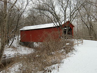
Sandy Creek Covered Bridge State Historic Site is a publicly owned property in Jefferson County, Missouri, administered by the Missouri Department of Natural Resources, preserving the Sandy Creek Covered Bridge. The bridge is one of four remaining covered bridges in Missouri, which once numbered about 30. It is a relatively rare example of a Howe truss bridge, one of three in Missouri. The covered bridge is named for Sandy Creek, which it crosses, and was added to the National Register of Historic Places in 1970.

The Sweeney-Conner cabin is a structure within the Appomattox Court House National Historical Park. It was registered in the National Park Service's database of Official Structures on June 26, 1989.

Barnesville station is a historic train station in Barnesville, Ohio. It is located at 300 East Church Street, between Mulberry and Railroad Streets. The building was placed on the National Register of Historic Places on August 8, 1985 as the Barnesville Baltimore and Ohio Railroad Depot.

The Barnesville Historic District consists of the oldest part of Barnesville, Ohio, originally platted in 1808 and contains roughly 40 acres and 180 buildings. The district was added to the National Register on July 19, 1984.

This is a list of the National Register of Historic Places listings in Callaway County, Missouri.

Fort Pemberton was one of the larger confederate forts was constructed in the defense of Charleston, South Carolina during the American Civil War. When Charleston was overwhelmed by Union forces in 1861, it became evident that control of the western regions of James Island and the Stono River was to be an important element in the defense of the city. Confederate military authorities of the time believed that Union occupation of James Island would leave Charleston subject to attack from the southeast. From this position the city would assuredly fall to the Union. Although there were many gun batteries in place along the south and east side of James Island, Fort Pemberton was the only fortress in defense of this region.

Roper's Knob Fortifications were constructed by Union Army forces between February and May 1863 in Franklin, Tennessee. According to Tennessee Archaeology, "Roper's Knob served as part of a chain of signal stations that provided a communications link from Franklin to Murfreesboro. Additionally the knob had a large redoubt capable of holding four large artillery pieces, a blockhouse, cisterns, and a magazine. ... "

The Provo Canyon Guard Quarters is a historic building located in Provo, Utah. It is listed on the National Register of Historic Places.
The Tate's Bluff Fortification is a historic American Civil War fortification in northern Ouachita County, Arkansas. It is located near the confluence of the Ouachita and Little Missouri Rivers, near County Route 25. The roughly square earthworks is believed to have been built in 1864, after Union Army forces captured Little Rock, as an effort by Confederate Army forces to fortify the Ouachita against a potential Union advance. It saw no combat, and was probably only used as an observation and supply post.
The Wittsburg Fortification is a defensive earthworks built during the American Civil War in Wittsburg, Arkansas. It is the only known surviving earthworks built by either side during the Union Army's advance on Little Rock in 1862. Union forces invaded Arkansas from Missouri on July 19, 1862, moving south along Crowley's Ridge, which lies west of the St. Francis River. By July 29 most of the division of General John Davidson had advanced as far as Wittsburg, where they established a camp to wait for supplies and reinforcements. A stockade and ditch were built on the ridge overlooking the area.

Fort Benton, also known as Fort Hill, is a historic American Civil War fortification located near Patterson, Wayne County, Missouri. Its earthen walls measure approximately 100 feet by 100 feet. The fortification supported an encampment of Union troops stationed at Patterson to secure the area against local Confederate guerillas. It was also one of a string of fortifications designed protect Union Missouri from invasion from Confederate Arkansas.


