Maes Knoll is an Iron Age hill fort in Somerset, England, located at the eastern end of the Dundry Down ridge, south of the city of Bristol and north of the village of Norton Malreward near the eastern side of Dundry Hill. It is a Scheduled Ancient Monument.

Maesbury Castle is an Iron Age hill fort within the parish of Croscombe on the Mendip Hills, just north of Shepton Mallet, Somerset, England. It has been listed as a Scheduled Ancient Monument.
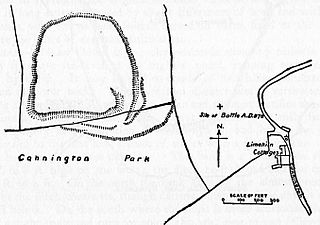
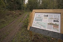
Cannington Camp is a Bronze Age and Iron Age hill fort near Cannington, Somerset, England. It is a Scheduled Ancient Monument.

Bats Castle is an Iron Age hill fort at the top of a 213 metres (699 ft) high hill in the parish of Carhampton south south west of Dunster in Somerset, England.

Black Ball Camp is an Iron Age hill fort South West of Dunster, Somerset, England on the northern summit of Gallox Hill. It is a Scheduled Ancient Monument.
Blacker's Hill is an Iron Age hill fort at Chilcompton, 4.5 kilometres (3 mi) south west of Radstock, Somerset, England. It has been designated as a Scheduled Ancient Monument.

Clatworthy Camp is an Iron Age hill fort 3 miles (4.8 km) North West of Wiveliscombe, Somerset, England. It has been scheduled as an Ancient Monument. Due to the vulnerability to scrub and tree growth it has been added to the Heritage at Risk Register.

Kenwalch's Castle is probably an Iron Age hill fort that may have been converted into a Roman fortress, near Penselwood, Somerset, England, 6.6 kilometres (4 mi) east south east of Bruton at grid reference ST747335. It is a Scheduled Ancient Monument. It is believed to be named after Cenwalh of Wessex.
Kingsdown Camp is an Iron Age hill fort at Buckland Dinham 4.5 kilometres (3 mi) South East of Radstock, Somerset, England. It is a Scheduled Ancient Monument.

Tedbury Camp is a multivallate Iron Age promontory hill fort defended by two parallel banks near Great Elm, Somerset, England.

Banwell Camp is a univallate Iron Age hill fort in the North Somerset district of Somerset, England. The hill fort is situated approximately 1.6 miles (2.6 km) east from the Village of Banwell. Some artefacts found on the site dates back to the Bronze Age and the Stone Age. In places it is surrounded by a 4 metres (13 ft) high bank and ditch.

King's Castle is a Neolithic hillfort 1 kilometre (0.62 mi) east of Wiveliscombe in Somerset, England. It is surrounded by two banks with a ditch between them. The inner wall ranges up to 2.5 metres (8.2 ft) high and the outer wall gets up to 1.5 metres (4.9 ft) high. Arrowheads, scrapers, and borers have been found at the site. A coin hoard of 1139 coins was found in a pot buried 0.30 metres (1 ft) deep.
Curdon Camp is a univallate Iron Age hill fort in the West Somerset district of Somerset, England. It is a Scheduled Ancient Monument.

Roddenbury Hillfort is a univallate Iron Age hillfort in the parish of Selwood, Somerset, England. It is a Scheduled Monument and it was on the Heritage at Risk Register in 2011. In 2012 it was announced that it was to undergo major repairs following damage by off road biking. It is close to the later Hales Castle.
Taps Combe Camp is an Iron Age hill fort in North Somerset, England. The hill fort is situated approximately 1.8 miles (2.9 km) east from the village of Brockley. The hill fort is shaped a lot like a "D", and is approximately 50 metres (160 ft) by 50 metres (160 ft) wide.

Mounsey Castle is an Iron Age irregular triangular earthwork of 1.75 hectares north west of Dulverton, Somerset, England. It has been scheduled as an ancient monument. It has been added to the Heritage at Risk Register.
Conygar Hillfort is a small multivallate Iron Age hill fort in the North Somerset district of Somerset, England. It is a Scheduled Ancient Monument.

Highbury Hill in Clutton, Somerset, England is the site of the earthwork remains of an Iron Age univallate hillfort. It occupies an area of woodland at the end of a narrow ridge. It is a Scheduled Ancient Monument, meaning that it is a nationally important archaeological site or historic building, given protection against unauthorised change.

Long Wood Enclosure is an enclosure which may have been a univallate Iron Age hill fort, in the West Somerset district of Somerset, England. The hill fort is situated approximately 3.5 kilometres (2.2 mi) southwest of the village of Dunster. It has been scheduled as an ancient monument.
East Myne is a univallate Iron Age hill fort enclosure in the West Somerset district of Somerset, England. The hill fort is situated approximately 1.1 miles (1.8 km) west from the town of Minehead. The hill fort is considered to be a deserted post-medieval farmstead.