Cobalt, Missouri

Last updated

Cobalt, Missouri
Cobalt Village [1]
Madison County Missouri Incorporated and Unincorporated areas Cobalt Highlighted.svg
Location in Madison County and the state of Missouri
Coordinates: 37°32′44″N90°17′15″W / 37.54556°N 90.28750°W / 37.54556; -90.28750
Country United States
State Missouri
County Madison
Area
[2]
  Total0.15 sq mi (0.39 km2)
  Land0.15 sq mi (0.39 km2)
  Water0.00 sq mi (0.00 km2)
Elevation
[1]
774 ft (236 m)
Population
 (2020) [3]
  Total264
  Density1,771.81/sq mi (685.25/km2)
Time zone UTC-6 (Central (CST))
  Summer (DST) UTC-5 (CDT)
ZIP code
Area code 573
FIPS code 29-15220 [5]
GNIS feature ID753200 [1]

Cobalt is a village in Madison County, Missouri, United States. As of the 2020 census, the population was 264, [6] up from 226 in 2010.

Contents

Geography

The village is in northeastern Madison County, bordered to the north by the city of Fredericktown, the county seat. According to the U.S. Census Bureau, the village has a total area of 0.15 square miles (0.39 km2), all land. [2]

Demographics

Historical population
CensusPop.Note
1960 434
1970 238−45.2%
1980 27214.3%
1990 254−6.6%
2000 189−25.6%
2010 22619.6%
2020 26416.8%
U.S. Decennial Census [7]

2010 census

As of the census [8] of 2010, there were 226 people, 94 households, and 56 families living in the village. The population density was 1,506.7 inhabitants per square mile (581.7/km2). There were 104 housing units at an average density of 693.3 per square mile (267.7/km2). The racial makeup of the village was 99.56% White and 0.44% from two or more races. Hispanic or Latino of any race were 1.77% of the population.

There were 94 households, of which 27.7% had children under the age of 18 living with them, 44.7% were married couples living together, 9.6% had a female householder with no husband present, 5.3% had a male householder with no wife present, and 40.4% were non-families. 31.9% of all households were made up of individuals, and 8.5% had someone living alone who was 65 years of age or older. The average household size was 2.40 and the average family size was 3.09.

The median age in the village was 39.8 years. 23% of residents were under the age of 18; 8.9% were between the ages of 18 and 24; 26.1% were from 25 to 44; 31% were from 45 to 64; and 11.1% were 65 years of age or older. The gender makeup of the village was 48.7% male and 51.3% female.

2000 census

As of the 2000 United States Census, [5] there were 189 people, 79 households, and 54 families living in the village. The population density was 1,300.8 inhabitants per square mile (502.2/km2). There were 89 housing units at an average density of 612.5 per square mile (236.5/km2). The racial makeup of the village was 100.00% White.

There were 79 households, out of which 27.8% had children under the age of 18 living with them, 53.2% were married couples living together, 13.9% had a female householder with no husband present, and 31.6% were non-families. 24.1% of all households were made up of individuals, and 10.1% had someone living alone who was 65 years of age or older. The average household size was 2.39 and the average family size was 2.91.

In the village, the population was spread out, with 23.3% under the age of 18, 10.6% from 18 to 24, 28.6% from 25 to 44, 26.5% from 45 to 64, and 11.1% who were 65 years of age or older. The median age was 37 years. For every 100 females, there were 103.2 males. For every 100 females age 18 and over, there were 93.3 males.

The median income for a household in the village was $20,962, and the median income for a family was $21,923. Males had a median income of $19,792 versus $12,500 for females. The per capita income for the village was $9,361. About 1.8% of families and 8.4% of the population were below the poverty line, including none of those under the age of eighteen and 7.1% of those 65 or over.

Related Research Articles

<span class="mw-page-title-main">Cedar Hill Lakes, Missouri</span> Village in Missouri, United States

Cedar Hill Lakes is a village in Jefferson County, Missouri, United States. The population was 203 at the 2020 census.

<span class="mw-page-title-main">Country Life Acres, Missouri</span> Village in Missouri, United States

Country Life Acres is a village in St. Louis County, Missouri, United States. The population was 72 at the 2020 census.

<span class="mw-page-title-main">Sycamore Hills, Missouri</span> Village in Missouri, United States

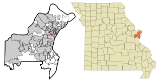
Sycamore Hills is a village in St. Louis County, Missouri, United States. The population is 560 at the 2020 census.

<span class="mw-page-title-main">Wilbur Park, Missouri</span> Village in Missouri, United States

Wilbur Park is a village in St. Louis County, Missouri, United States. The population was 439 at the 2020 census.

<span class="mw-page-title-main">Uplands Park, Missouri</span> Village in Missouri, United States

Uplands Park is a village in St. Louis County, Missouri, United States. The population was 445 at the 2010 census. The village is one of many small majority black communities located in the Natural Bridge corridor of mid-St. Louis County, characterized by small homes on small lots.

<span class="mw-page-title-main">Nellie, Ohio</span> Village in Ohio, United States

Nellie is a village in Coshocton County, Ohio, United States, along the Walhonding River. The population was 122 at the 2020 census.

<span class="mw-page-title-main">Cuyahoga Heights, Ohio</span> Village in Ohio, United States

Cuyahoga Heights is a village in Cuyahoga County, Ohio, United States. The population was 573 at the 2020 census. A suburb of Cleveland, it is a part of the Cleveland metropolitan area.

<span class="mw-page-title-main">Wayne Lakes, Ohio</span> Village in Ohio, United States

Wayne Lakes is a village in Darke County, Ohio, United States. The population was 693 at the 2020 census.

<span class="mw-page-title-main">Addyston, Ohio</span> Village in Ohio, United States

Addyston is a village in Miami Township, Hamilton County, Ohio, United States. Located along the Ohio River, it is a western suburb of the neighboring city of Cincinnati. The population was 927 at the 2020 census.

<span class="mw-page-title-main">Hanover, Ohio</span> Village in Ohio, United States

Hanover is a village in Licking County, Ohio, United States. The population was 1,270 at the 2020 census. The village lies along Ohio State Route 16.

<span class="mw-page-title-main">Rochester, Ohio</span> Village in Ohio

Rochester is a village in Lorain County, Ohio, United States, along the West Branch of the Black River. The population was 159 at the 2020 census.

<span class="mw-page-title-main">Melrose, Ohio</span> Village in Ohio, United States

Melrose is a village in Paulding County, Ohio, United States. The population was 233 at the 2020 census.

<span class="mw-page-title-main">Tarlton, Ohio</span> Village in Ohio, United States

Tarlton is a village in Fairfield and Pickaway counties in the U.S. state of Ohio. The population was 254 at the 2020 census.

<span class="mw-page-title-main">Roswell, Ohio</span> Village in Ohio, United States

Roswell is a village in Tuscarawas County, Ohio, United States. The population was 219 at the 2020 census.

<span class="mw-page-title-main">Clearview, West Virginia</span> Village in West Virginia, United States

Clearview is a village in Ohio County, West Virginia, United States. It is part of the Wheeling, West Virginia Metropolitan Statistical Area. The population was 565 at the 2010 census.

<span class="mw-page-title-main">Kekoskee, Wisconsin</span> Village in Wisconsin, United States

Kekoskee is a village in Dodge County, Wisconsin, United States. The population was 161 at the 2010 census.

<span class="mw-page-title-main">Avoca, Wisconsin</span> Village in Wisconsin, United States

Avoca is a village in Iowa County, Wisconsin, United States. The population was 637 at the 2010 census. It is part of the Madison Metropolitan Statistical Area. It is named after Avoca in Ireland.

<span class="mw-page-title-main">Verona, Ohio</span> Village in Ohio, United States

Verona is a village in Montgomery and Preble counties in the U.S. state of Ohio. The population was 403 at the 2020 census. It is part of the Dayton Metropolitan Statistical Area.

<span class="mw-page-title-main">Dallas, Wisconsin</span> Village in Wisconsin, United States

Dallas is a village in Barron County in the U.S. state of Wisconsin. The population was 409 at the 2010 census. The village is located within the Town of Dallas.

<span class="mw-page-title-main">Lowell, Wisconsin</span> Village in Wisconsin, United States

Lowell is a village in Dodge County, Wisconsin, United States, along the Beaver Dam River. The population was 340 at the 2010 census. The village is located within the Town of Lowell.

References

  1. 1 2 3 "Cobalt Village". Geographic Names Information System . United States Geological Survey, United States Department of the Interior.
  2. 1 2 "2023 U.S. Gazetteer Files: Missouri". United States Census Bureau. Retrieved March 20, 2024.
  3. "P1. Race – Cobalt village, Missouri: 2020 DEC Redistricting Data (PL 94-171)". U.S. Census Bureau. Retrieved March 20, 2024.
  4. "Cities by ZIP Code: 63645". U.S. Postal Service. Retrieved March 20, 2024.
  5. 1 2 "U.S. Census website". United States Census Bureau . Retrieved January 31, 2008.
  6. "Explore Census Data". data.census.gov. Retrieved January 14, 2022.
  7. "Census of Population and Housing". Census.gov. Retrieved June 4, 2015.
  8. "U.S. Census website". United States Census Bureau . Retrieved July 8, 2012.