Marquand, Missouri

Last updated

Marquand, Missouri
Madison County Missouri Incorporated and Unincorporated areas Marquand Highlighted.svg
Location in Madison County and the state of Missouri
Coordinates: 37°25′43″N90°10′01″W / 37.42861°N 90.16694°W / 37.42861; -90.16694 [1]
Country United States
State Missouri
County Madison
Area
[2]
  Total0.24 sq mi (0.62 km2)
  Land0.24 sq mi (0.62 km2)
  Water0.00 sq mi (0.01 km2)
Elevation
[1]
564 ft (172 m)
Population
 (2020) [3]
  Total186
  Density781.51/sq mi (301.45/km2)
Time zone UTC-6 (Central (CST))
  Summer (DST) UTC-5 (CDT)
ZIP code
63655
Area code 573
FIPS code 29-46244 [4]
GNIS feature ID2395016 [1]
Website www.marquandmo.org

Marquand is a small city in eastern Madison County, Missouri, United States. The population was 186 at the 2020 census. [5] Marquand was officially recognized and incorporated as a town in 1906.

Contents

History

Marquand was platted in 1869, and named after Henry G. Marquand, a railroad official. [6] A post office called Marquand has been in operation since 1870. [7]

Geography

Marquand is located adjacent to the Castor River on Missouri Route A. By road it is 14 miles (23 km) southeast of Fredericktown, the Madison county seat, and 17 miles (27 km) northwest of Marble Hill. Whitener Creek flows through the town from the northeast. [8]

According to the U.S. Census Bureau, Marquand has a total area of 0.24 square miles (0.62 km2), of which 0.002 square miles (1.3 acres), or 0.83%, are water. [2]

Demographics

Historical population
CensusPop.Note
1910 339
1920 3523.8%
1930 42921.9%
1940 403−6.1%
1950 369−8.4%
1960 3926.2%
1970 4002.0%
1980 397−0.7%
1990 278−30.0%
2000 251−9.7%
2010 203−19.1%
2020 186−8.4%
U.S. Decennial Census [9]

2010 census

As of the census [10] of 2010, there were 203 people, 92 households, and 56 families living in the city. The population density was 845.8 inhabitants per square mile (326.6/km2). There were 108 housing units at an average density of 450.0 per square mile (173.7/km2). The racial makeup of the city was 100.00% White. Hispanic or Latino of any race were 0.49% of the population.

There were 92 households, of which 37.0% had children under the age of 18 living with them, 42.4% were married couples living together, 13.0% had a female householder with no husband present, 5.4% had a male householder with no wife present, and 39.1% were non-families. 34.8% of all households were made up of individuals, and 15.2% had someone living alone who was 65 years of age or older. The average household size was 2.21 and the average family size was 2.80.

The median age in the city was 40.5 years. 23.6% of residents were under the age of 18; 8.9% were between the ages of 18 and 24; 21.1% were from 25 to 44; 32.5% were from 45 to 64; and 13.8% were 65 years of age or older. The gender makeup of the city was 50.7% male and 49.3% female.

2000 census

As of the census [4] of 2000, there were 251 people, 95 households, and 66 families living in the city. The population density was 1,035.6 inhabitants per square mile (399.8/km2). There were 124 housing units at an average density of 511.6 per square mile (197.5/km2). The racial makeup of the city was 97.21% White, 0.40% Native American, 0.40% Asian, 0.40% from other races, and 1.59% from two or more races. Hispanic or Latino of any race were 1.20% of the population.

There were 95 households, out of which 35.8% had children under the age of 18 living with them, 46.3% were married couples living together, 15.8% had a female householder with no husband present, and 30.5% were non-families. 28.4% of all households were made up of individuals, and 15.8% had someone living alone who was 65 years of age or older. The average household size was 2.64 and the average family size was 3.21.

In the city the population was spread out, with 31.9% under the age of 18, 6.8% from 18 to 24, 28.7% from 25 to 44, 17.9% from 45 to 64, and 14.7% who were 65 years of age or older. The median age was 31 years. For every 100 females, there were 69.6 males. For every 100 females age 18 and over, there were 72.7 males.

The median income for a household in the city was $19,861, and the median income for a family was $25,000. Males had a median income of $30,341 versus $12,083 for females. The per capita income for the city was $8,533. About 25.0% of families and 32.5% of the population were below the poverty line, including 50.0% of those under the age of eighteen and 27.5% of those 65 or over.

Education

The Marquand-Zion R-VI School District runs throughout most of eastern and southeastern Madison County and serves the educational needs of the town's residents and nearby. A small, rural school, the district consists of one elementary and one consolidated junior-senior high school. According to the Missouri Department of Elementary and Secondary Education, there was a total of 184 students and 35 certified staff members enrolled in the Marquand-Zion R-VI School District during the 2008–2009 school year. The school colors are purple and gold and its mascot is the tiger. Athletics offered in the school district include boys' basketball and baseball, girls' volleyball, and cheerleading.

Related Research Articles

<span class="mw-page-title-main">Madison County, Missouri</span> County in Missouri, United States

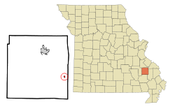
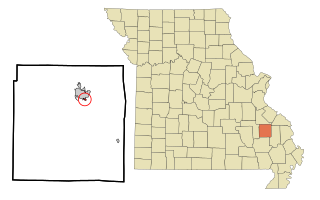
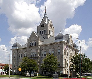
Madison County is a county located in the Lead Belt region of the U.S. state of Missouri. As of the 2020 census, the population was 12,626. Its county seat and largest city is Fredericktown. The county was officially organized on December 14, 1818, and was named after President James Madison.

<span class="mw-page-title-main">St. Charles, Iowa</span> City in Iowa, United States

St. Charles is a city in Madison County, Iowa, United States. The population was 640 at the time of the 2020 census. It is part of the Des Moines–West Des Moines Metropolitan Statistical Area.

<span class="mw-page-title-main">Belton, Missouri</span> City in Missouri, United States

Belton is a city in northwestern Cass County, Missouri, United States. The population was 23,116 at the 2010 census.

<span class="mw-page-title-main">Alexandria, Missouri</span> City in Missouri, United States

Alexandria is a city in eastern Clark County, Missouri, United States. As of the 2020 census, its population was 105.

<span class="mw-page-title-main">Kahoka, Missouri</span> City in Missouri, United States

Kahoka is a city in and the county seat of Clark County, in the northeast tip of Missouri, United States. As of the 2020 census, its population was 1,961.

<span class="mw-page-title-main">Wayland, Missouri</span> City in Missouri, United States

Wayland is a city in Clark County, Missouri, United States. As of the 2020 census, its population was 408. It is part of the Fort Madison–Keokuk, IA-MO Micropolitan Statistical Area.

<span class="mw-page-title-main">Wyaconda, Missouri</span> City in Missouri, United States

Wyaconda is a city in Clark County, Missouri, United States. As of the 2020 census, its population was 214. The city was organized in 1888 and is named after a Siouan name for God or the Great Spirit. The first land purchased from the Santa Fe and Land Co. was in 1888.

<span class="mw-page-title-main">Smithville, Missouri</span> City in Missouri, United States

Smithville is a city in Clay and Platte counties in the U.S. state of Missouri and is part of the Kansas City metropolitan area, along the Little Platte River. The population was 10,406 at the 2020 United States Census.

<span class="mw-page-title-main">Washington, Missouri</span> City in the United States

Washington is a city on the south banks of the Missouri River, 50 miles west of St. Louis, Missouri, and the largest in Franklin County, Missouri, United States. The estimated population in July 2021 was 14,916, an increase of 7% since the 2010 census. It is the corncob pipe capital of the world, with Missouri Meerschaum located on the riverfront.

<span class="mw-page-title-main">Elmer, Missouri</span> City in Missouri, United States

Elmer is a city in Macon County, Missouri, United States. The population was 51 at the 2020 census, down from 80 in 2010.

<span class="mw-page-title-main">Cobalt, Missouri</span> Village in Missouri, United States

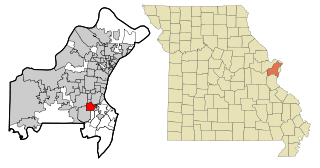
Cobalt is a village in Madison County, Missouri, United States. As of the 2020 census, the population was 264, up from 226 in 2010.

<span class="mw-page-title-main">Junction City, Missouri</span> Village in Missouri, United States

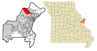
Junction City is a village in Madison County, Missouri, United States. The population was 283 at the 2020 census, down from 327 in 2010.

<span class="mw-page-title-main">Madison, Missouri</span> City in Missouri, United States

Madison is a city in Monroe County, Missouri, United States. The population was 515 at the 2020 census.

<span class="mw-page-title-main">Bolivar, Missouri</span> City in Missouri, United States

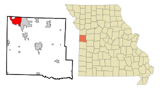
Bolivar is a city and county seat of Polk County, Missouri, United States.

<span class="mw-page-title-main">Benton, Missouri</span> City in Missouri, United States

Benton is a city in Scott County, Missouri, United States. The population was 863 at the 2010 census. It is the county seat of Scott County.

<span class="mw-page-title-main">Crestwood, Missouri</span> City in the United States

Crestwood is a city in south St. Louis County, Missouri, United States, part of the Metropolitan Statistical Area known as Greater St. Louis. The population was 11,912 at the 2010 census.

<span class="mw-page-title-main">Hazelwood, Missouri</span> City in Missouri, United States

Hazelwood is a city in St. Louis County, Missouri, within Greater St. Louis. It is a second-ring northern suburb of St. Louis. Based on the 2020 United States census, the city had a total population of 25,485. It is located north of St. Louis-Lambert International Airport and is situated on Interstates 270 and 170, as well as the much-traveled Lindbergh Boulevard and Highway 370.

<span class="mw-page-title-main">Manchester, Missouri</span> City in Missouri, United States

Manchester is a city in St. Louis County, Missouri, United States. The population was 18,333 at the 2020 census.

<span class="mw-page-title-main">Wildwood, Missouri</span> City in Missouri, United States

Wildwood is a city in St. Louis County, Missouri, United States. It is located in the far western portion of the county. As of the 2020 census, the population was 35,417. Wildwood is the home of the Al Foster Trail, and numerous other trails, parks, and reserves such as Rockwoods Reservation and Babler State Park.

<span class="mw-page-title-main">Newman Grove, Nebraska</span> City in Platte County, Nebraska, United States

Newman Grove is a city in Madison and Platte counties in Nebraska, United States. The population was 721 at the 2010 census.

References

  1. 1 2 3 U.S. Geological Survey Geographic Names Information System: Marquand, Missouri
  2. 1 2 "2023 U.S. Gazetteer Files: Missouri". United States Census Bureau. Retrieved March 20, 2024.
  3. "P1. Race – Marquand city, Missouri: 2020 DEC Redistricting Data (PL 94-171)". U.S. Census Bureau. Retrieved March 20, 2024.
  4. 1 2 "U.S. Census website". United States Census Bureau . Retrieved January 31, 2008.
  5. "Explore Census Data". data.census.gov. Retrieved January 14, 2022.
  6. "Madison County Place Names, 1928–1945". The State Historical Society of Missouri. Archived from the original on June 24, 2016. Retrieved October 31, 2016.
  7. "Post Offices". Jim Forte Postal History. Retrieved October 31, 2016.
  8. Marquand, Missouri, 7.5 Minute Topographic Quadrangle, USGS, 1980
  9. "Census of Population and Housing". Census.gov. Retrieved June 4, 2015.
  10. "U.S. Census website". United States Census Bureau . Retrieved July 8, 2012.