Junction City, Missouri

Last updated

Junction City, Missouri
Madison County Missouri Incorporated and Unincorporated areas Junction City Highlighted.svg
Location in Madison County and the state of Missouri
Coordinates: 37°34′24″N90°17′26″W / 37.57333°N 90.29056°W / 37.57333; -90.29056
Country United States
State Missouri
County Madison
Area
[1]
  Total0.36 sq mi (0.93 km2)
  Land0.36 sq mi (0.93 km2)
  Water0.00 sq mi (0.01 km2)
Elevation
[2]
778 ft (237 m)
Population
 (2020) [3]
  Total283
  Density790.50/sq mi (305.05/km2)
Time zone UTC-6 (Central (CST))
  Summer (DST) UTC-5 (CDT)
ZIP code
Area code 573
FIPS code 29-37736 [4]
GNIS feature ID2398317 [2]

Junction City is a village in Madison County, Missouri, United States. The population was 283 at the 2020 census, [3] down from 327 in 2010.

Contents

Geography

Junction City is in northeastern Madison County, bordered to the south by Fredericktown, the county seat. Missouri Route 72 passes through the village, leading west 2 miles (3 km) to U.S. Route 67 and east 40 miles (64 km) to Jackson. State Highway OO leads north from Junction City 18 miles (29 km) to Farmington.

According to the U.S. Census Bureau, Junction City has a total area of 0.36 square miles (0.93 km2), of which 0.002 square miles (1.3 acres), or 0.56%, are water. [1] The village is within the watershed of the Little St. Francis River.

Demographics

Historical population
CensusPop.Note
1960 260
1970 166−36.2%
1980 23843.4%
1990 32637.0%
2000 319−2.1%
2010 3272.5%
2020 283−13.5%
U.S. Decennial Census [5]

2010 census

As of the census [6] of 2010, there were 327 people, 150 households, and 68 families living in the village. The population density was 908.3 inhabitants per square mile (350.7/km2). There were 179 housing units at an average density of 497.2 per square mile (192.0/km2). The racial makeup of the village was 96.94% White, 0.61% Black or African American, 0.31% Native Hawaiian or Pacific Islander, and 2.14% from two or more races. Hispanic or Latino of any race were 1.83% of the population.

There were 150 households, of which 28.0% had children under the age of 18 living with them, 23.3% were married couples living together, 18.7% had a female householder with no husband present, 3.3% had a male householder with no wife present, and 54.7% were non-families. 44.7% of all households were made up of individuals, and 33.3% had someone living alone who was 65 years of age or older. The average household size was 2.18 and the average family size was 3.18.

The median age in the village was 34.7 years. 25.4% of residents were under the age of 18; 13.1% were between the ages of 18 and 24; 21.4% were from 25 to 44; 15% were from 45 to 64; and 25.1% were 65 years of age or older. The gender makeup of the village was 49.2% male and 50.8% female.

2000 census

As of the census [4] of 2000, there were 319 people, 158 households, and 73 families living in the village. The population density was 894.9 inhabitants per square mile (345.5/km2). There were 167 housing units at an average density of 468.5 per square mile (180.9/km2). The racial makeup of the village was 98.43% White, and 1.57% from two or more races.

There were 158 households, out of which 23.4% had children under the age of 18 living with them, 32.3% were married couples living together, 11.4% had a female householder with no husband present, and 53.2% were non-families. 48.1% of all households were made up of individuals, and 27.2% had someone living alone who was 65 years of age or older. The average household size was 2.02 and the average family size was 2.92.

In the village, the population was spread out, with 23.5% under the age of 18, 8.8% from 18 to 24, 24.1% from 25 to 44, 22.3% from 45 to 64, and 21.3% who were 65 years of age or older. The median age was 38 years. For every 100 females, there were 82.3 males. For every 100 females age 18 and over, there were 78.1 males.

The median income for a household in the village was $15,833, and the median income for a family was $21,250. Males had a median income of $25,417 versus $8,500 for females. The per capita income for the village was $11,561. About 30.1% of families and 37.3% of the population were below the poverty line, including 59.7% of those under age 18 and 14.8% of those age 65 or over.

Related Research Articles

<span class="mw-page-title-main">River Bend, Missouri</span> Village in Missouri, United States

River Bend is a village in Jackson County, Missouri, United States. The population was 3 at the 2020 census. It is the only part of Jackson County that lies north of the Missouri River. In 1951, the Missouri River was relocated to a new channel, creating River Bend,. The county line still follows the original riverbed. It is part of the Kansas City metropolitan area. The mayor is Alex Dockler.

<span class="mw-page-title-main">Carl Junction, Missouri</span> City in Missouri, United States

Carl Junction is a city in Jasper County, Missouri, United States. The population was 8,143 at the 2020 census.

<span class="mw-page-title-main">Cedar Hill Lakes, Missouri</span> Village in Missouri, United States

Cedar Hill Lakes is a village in Jefferson County, Missouri, United States. The population was 203 at the 2020 census.

<span class="mw-page-title-main">Evergreen, Missouri</span> Village in Missouri, United States

Evergreen is a village in Laclede County, Missouri, United States. The population was 28 at the 2010 census. It was named Twin Bridges at the 2000 census.

<span class="mw-page-title-main">Tuscumbia, Missouri</span> Town in Missouri, United States

Tuscumbia is a village in and the county seat of Miller County, Missouri, United States. The population was 203 at the 2010 census, at which time it was a town.

<span class="mw-page-title-main">Burlington Junction, Missouri</span> City in Missouri, United States

Burlington Junction is a city in Nodaway County, Missouri, United States. The population was 521 at the 2020 census.

<span class="mw-page-title-main">Conception Junction, Missouri</span> City in Missouri, United States

Conception Junction is a city in Nodaway County, Missouri, United States, near the Platte River. The population was 177 at the 2020 census.

<span class="mw-page-title-main">Ravenwood, Missouri</span> City in Missouri, United States

Ravenwood is a city in eastern Nodaway County, Missouri, United States, near the Platte River. The population was 439 at the 2020 census.

<span class="mw-page-title-main">Tarrants, Missouri</span> Village in Missouri, United States

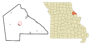
Tarrants is a village in central Pike County, Missouri, United States. The population was 22 at the 2010 census.

<span class="mw-page-title-main">Roscoe, Missouri</span> Village in Missouri, United States

Roscoe is a village in St. Clair County, Missouri, United States. The population was 89 at the 2020 census.

<span class="mw-page-title-main">Country Life Acres, Missouri</span> Village in Missouri, United States

Country Life Acres is a village in St. Louis County, Missouri, United States. The population was 72 at the 2020 census.

<span class="mw-page-title-main">Glen Echo Park, Missouri</span> Former Village in Missouri, United States

Glen Echo Park was a village in St. Louis County, Missouri, United States. The population was 122 at the 2020 census. The community took its name from the nearby Glen Echo Country Club.

<span class="mw-page-title-main">Hillsdale, Missouri</span> Village in Missouri, United States

Hillsdale is a village in St. Louis County, Missouri, United States. Greenwood Cemetery is located in Hillsdale. The population was 1,478 at the 2010 census.

<span class="mw-page-title-main">Marlborough, Missouri</span> Village in Missouri, United States

Marlborough is a village in St. Louis County, Missouri, United States. The population was 2,179 at the 2010 census.

<span class="mw-page-title-main">Pasadena Park, Missouri</span> Village in Missouri, United States

Pasadena Park is a village in St. Louis County, Missouri, United States. The population was 470 at the 2010 census. It is part of the Normandy School District, and is distinct from the city of Pasadena Hills.

<span class="mw-page-title-main">Penermon, Missouri</span> Village in Missouri, United States

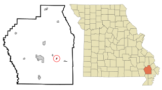
Penermon is a village in Stoddard County, Missouri, United States. The population was 64 at the 2010 census.

<span class="mw-page-title-main">Champ, Missouri</span> Village in Missouri, United States

Champ is a village in St. Louis County, Missouri, United States. The population was 10 at the 2020 census.

<span class="mw-page-title-main">Hanley Hills, Missouri</span> Village in Missouri, United States

Hanley Hills is a village in St. Louis County, Missouri, United States. The population was 2,101 at the 2010 census.

<span class="mw-page-title-main">Uplands Park, Missouri</span> Village in Missouri, United States

Uplands Park is a village in St. Louis County, Missouri, United States. The population was 445 at the 2010 census. The village is one of many small majority black communities located in the Natural Bridge corridor of mid-St. Louis County, characterized by small homes on small lots.

<span class="mw-page-title-main">Junction City, Ohio</span> Village in Ohio, United States

Junction City is a village in Perry County, Ohio, United States. The population was 721 at the 2020 census.

References

  1. 1 2 "2023 U.S. Gazetteer Files: Missouri". United States Census Bureau. Retrieved March 20, 2024.
  2. 1 2 U.S. Geological Survey Geographic Names Information System: Junction City, Missouri
  3. 1 2 "P1. Race – Junction City village, Missouri: 2020 DEC Redistricting Data (PL 94-171)". U.S. Census Bureau. Retrieved March 20, 2024.
  4. 1 2 "U.S. Census website". United States Census Bureau . Retrieved January 31, 2008.
  5. "Census of Population and Housing". Census.gov. Retrieved June 4, 2015.
  6. "U.S. Census website". United States Census Bureau . Retrieved July 8, 2012.