Columbine-Hondo Wilderness

Last updated
Columbine-Hondo Wilderness
IUCN category Ib (wilderness area)
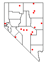
Location Taos County, New Mexico, United States
Area44,698 acres (18,089 ha)
Established2014-12-19
Governing body U.S. Forest Service

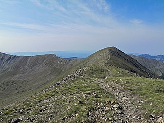
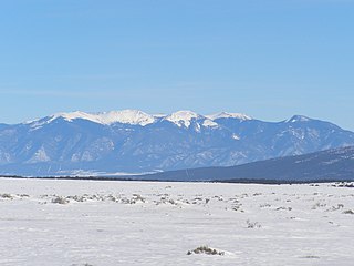
Coordinates: 36°38′37″N105°27′22″W / 36.64361°N 105.45611°W / 36.64361; -105.45611 Columbine-Hondo Wilderness is a 44,698-acre (18,089 ha) Wilderness area located within the Carson National Forest in New Mexico. The area was added to the National Wilderness Preservation System on December 19, 2014 by Public Law 113-291. [1] Located in the Sangre de Cristo Mountains, this area contains the headwaters to the Rio Hondo and Red River as well as three peaks which rise to or above timberline. [2]

Geographic coordinate system Coordinate system

A geographic coordinate system is a coordinate system that enables every location on Earth to be specified by a set of numbers, letters or symbols. The coordinates are often chosen such that one of the numbers represents a vertical position and two or three of the numbers represent a horizontal position; alternatively, a geographic position may be expressed in a combined three-dimensional Cartesian vector. A common choice of coordinates is latitude, longitude and elevation. To specify a location on a plane requires a map projection.

A wilderness area is a region where the land is in a natural state; where impacts from human activities are minimal—that is, as a wilderness. It might also be called a wild or natural area. Especially in wealthier, industrialized nations, it has a specific legal meaning as well: as land where development is prohibited by law. Many nations have designated Wilderness Areas, including Australia, Canada, New Zealand, South Africa and the United States.

Carson National Forest national forest in the US state of New Mexico

Carson National Forest is a national forest in northern New Mexico, United States. It encompasses 6,070 square kilometers and is administered by the United States Forest Service. The Forest Service's "mixed use" policy allows for its use for recreation, grazing, and resource extraction.

Elevations in the wilderness range from 2,396 metres (7,861 ft) to 3,874 metres (12,710 ft) at Gold Hill. The other principal summits of the wilderness area are Lobo Peak (3,692 metres (12,113 ft)) and Flag Mountain (3,641 metres (11,946 ft)). The Colombine-Hondo Wilderness is separated from the Wheeler Peak Wilderness to the south only by Highway 150 and the Taos Ski Valley. Latir Peak Wilderness is located north of Colombine- Hondo Wilderness. [3]

Wheeler Peak Wilderness

The 19,661-acre (7,957 ha) Wheeler Peak Wilderness lies in the Carson National Forest of New Mexico. It contains the highest point in the state, 13,161-foot (4,011 m) Wheeler Peak as well as Williams Lake.

Latir Peak Wilderness

Latir Peak Wilderness is a 20,506-acre (8,298 ha) wilderness area located within the Carson National Forest in northern New Mexico, United States. Designated in 1980, the wilderness is composed of dense forest, meadows, and alpine tundra on Latir Mesa in the northern portion. It includes a portion of the Sangre de Cristo Mountains and contains four of the state's twenty highest peaks - Venado Peak at 12,734 feet (3,881 m), Latir Peak at 12,708 feet (3,873 m), Latir Mesa at 12,692 feet (3,869 m), and Virsylvia Peak at 12,594 feet (3,839 m). Most of the area is drained by the Lake Fork of Cabresto Creek, which originates at Heart Lake and is impounded just outside the wilderness in Cabresto Lake, the main trailhead for visitors entering the wilderness.

The wilderness has vegetation typical of the southern Rocky Mountains with Ponderosa Pine and Pinyon forests at lower elevations, mixed conifers and aspens at the middle elevations, spruce-fir forests at higher elevations, and alpine tundra above treeline.

Rocky Mountains mountain range in North America

The Rocky Mountains, also known as the Rockies, are a major mountain range in western North America. The Rocky Mountains stretch more than 4,800 kilometers (3,000 mi) from the northernmost part of British Columbia, in western Canada, to New Mexico in the Southwestern United States. Located within the North American Cordillera, the Rockies are somewhat distinct from the Pacific Coast Ranges, Cascade Range, and the Sierra Nevada, which all lie farther to the west.

Pinyon pine subsection of plants, the Pinyon pines

The pinyon or piñon pine group grows in the southwestern United States, especially in New Mexico, Arizona, and Utah. The trees yield edible nuts, which are a staple food of Native Americans, and widely eaten as a snack and as an ingredient in New Mexican cuisine. The name comes from the Spanish pino piñonero, a name used for both the American varieties and the stone pine common in Spain, which also produces edible nuts typical of Mediterranean cuisine. Harvesting techniques of the prehistoric American Indians are still used today to collect the pinyon seeds for personal use or for commercialization. The pinyon nut or seed is high in fats and calories.

Aspen common name for certain tree species

Aspen is a common name for certain tree species; some, but not all, are classified by botanists in the section Populus, of the Populus genus.

History

Columbine-Hondo was designated a Wilderness Study Area by congress in 1980. In April 2012, Senator Jeff Bingaman unsuccessfully introduced a bill (S.2468) to designate the area as wilderness. The bill (S.776) was re-introduced by Senators Martin Heinrich and Tom Udall in April 2013 followed by an identical house bill (H.R.1683) introduced by Representative Ben Ray Luyán. The bill was signed into law on December 19th, 2014. [4]

Wilderness study area

A wilderness study area (WSA) contains undeveloped United States federal land retaining its primeval character and influence, without permanent improvements or human habitation, and managed to preserve its natural conditions. WSAs are not included in the National Wilderness Preservation System until the United States Congress passes wilderness legislation.

Jeff Bingaman American politician

Jesse Francis Bingaman Jr. is an American politician who served as a United States Senator from New Mexico from 1983 to 2013. He is a member of the Democratic Party, and served as Chairman of Committee Outreach for the Senate Democratic Caucus. Previously, Bingaman was Attorney General of New Mexico from 1979 to 1983. On February 18, 2011, he announced that he would not seek reelection in 2012. He was replaced by fellow Democrat Martin Heinrich. After he left the Senate, he returned to his alma mater, Stanford Law School, as a fellow of their Steyer–Taylor Center for Energy Policy and Finance.

Martin Heinrich politician

Martin Trevor Heinrich is an American politician and businessman serving as the junior United States Senator from New Mexico since 2013.

Related Research Articles

Sangre de Cristo Mountains subrange of the Rocky Mountains in the US

The Sangre de Cristo Mountains are the southernmost subrange of the Rocky Mountains. They are located in southern Colorado and northern New Mexico in the United States. The mountains run from Poncha Pass in South-Central Colorado, trending southeast and south, ending at Glorieta Pass, southeast of Santa Fe, New Mexico. The mountains contain a number of fourteen thousand foot peaks in the Colorado portion, as well as all the peaks in New Mexico which are over thirteen thousand feet.

White River National Forest

White River National Forest is a National Forest in northwest Colorado. It is named after the White River that passes through its northern section. It is the most visited National Forest in the United States, primarily from users of the twelve ski areas within its boundaries.

Flat Tops Wilderness Area

Flat Tops Wilderness Area is the third largest U.S. Wilderness Area in Colorado. It is 235,214 acres (951.88 km2), with 38,870 acres (157.3 km2) in Routt National Forest and 196,344 acres (794.58 km2) in White River National Forest. It was designated a wilderness area in 1975. Trappers Lake, located in the north of the area, was the lake that inspired Arthur Carhart, a United States Forest Service official, to plead for wilderness preservation.

Lincoln National Forest national forest in the US state of New Mexico

Lincoln National Forest is a unit of the U.S. Forest Service located in southern New Mexico. Established by Presidential Proclamation in 1902 as the Lincoln Forest Preserve, the 1,103,897 acres (4,467.31 km2) forest begins near the Texas border and contains lands in parts of Chaves, Eddy, Lincoln, and Otero, counties. The three Ranger Districts within the forest contain all or part of four mountain ranges, and include a variety of different environmental areas, from desert to heavily forested mountains and sub-alpine grasslands. Established to balance conservation, resource management, and recreation, the lands of the Lincoln National Forest include important local timber resources, protected wilderness areas, and popular recreation and winter sports areas. The forest headquarters is located in Alamogordo, N.M. with local offices in Carlsbad, Cloudcroft, and Ruidoso.

Sapphire Mountains mountain range in Montana, United States

The Sapphire Mountains are a range of mountains located in southwestern Montana in the northwestern United States. From a point near the Clark Fork River and the city of Missoula, they run in a southerly direction for a distance of approximately 60 miles (100 km), making up much of the border between Ravalli County and Granite County. To the west is the Bitterroot Valley, and to the east is Rock Creek. The southern end of the range meets the larger Anaconda Range at West Pintler Peak.

Nevada Wilderness Areas

In 1989 the U.S. Government enacted the Nevada Wilderness Bill, expanding the one existing Wilderness Area (Jarbidge) and creating thirteen new areas. The estimated total of 733,400 acres (296,800 ha) was over eleven times the area that had previously been under wilderness protection.

Spanish Peaks mountain in United States of America

The Spanish Peaks are a pair of prominent mountains located in southwestern Huerfano County, Colorado. The Ute Indians named them Huajatolla, meaning "two breasts" or "breasts of the Earth".

Lone Peak Wilderness

The Lone Peak Wilderness is a 30,088-acre (121.76 km2) wilderness area located within the Uinta and the Wasatch-Cache National Forest in the U.S. state of Utah.

Gila Wilderness the worlds first wilderness area in the US state of New Mexico

Gila Wilderness was designated the world's first wilderness area on June 3, 1924. Along with Aldo Leopold Wilderness and Blue Range Wilderness, the 558,014 acres (225,820 ha) wilderness is part of New Mexico's Gila National Forest. The wilderness is approximately 27 miles (43 km) from north to south and 39 miles (63 km) east to west. U.S. Wilderness Areas do not allow motorized or mechanized vehicles, including bicycles. Camping and fishing are allowed with proper permit, but no roads, buildings, logging, or mining are permitted. Wilderness areas within National Forests and Bureau of Land Management areas allow hunting in season.

Magdalena Mountains

The Magdalena Mountains are a regionally high, mountain range in Socorro County, in west-central New Mexico in the southwestern United States. The highest point in the range is South Baldy, at 10,783 ft, which is also the tallest peak in Socorro County. The range runs roughly north-south and is about 18 miles (28 km) long. The range lies just south of the village of Magdalena, and about 18 miles (28 km) west of Socorro. The Magdalena Mountains are an east-tilted fault-block range, superimposed on Cenozoic calderas. The complex geologic history of the range has resulted in spectacular scenery, with unusual and eye-catching rock formations. They form part of the western edge of the Rio Grande Rift Valley, fronting the La Jencia Basin. The mountains remain isolated and natural due to the absence of any significant human development within or near the range.

Snow Mountain Wilderness

The Snow Mountain Wilderness is a 60,076-acre (243.12 km2) federally designated wilderness area located 65 miles (105 km) north of Santa Rosa, California, USA in the Mendocino National Forest. The U.S. Congress passed the California Wilderness Act of 1984 which created 23 new wilderness areas including Snow Mountain. It lies within the North Coast Range of mountains.

Dinkey Lakes Wilderness

The Dinkey Lakes Wilderness is a federally designated wilderness area located 45 miles (72 km) northeast of Fresno, in the state of California, USA. It comprises 30,000 acres (12,141 ha) within the Sierra National Forest and was added to the National Wilderness Preservation System by the California Wilderness Act of 1984.

Mount Skokomish Wilderness

Mount Skokomish Wilderness is a designated wilderness area in the southeast portion of Olympic National Forest on the Olympic Peninsula of Washington in the United States. The wilderness area comprises 13,291 acres (5,379 ha) administered by the U.S. Forest Service.

Omnibus Public Land Management Act of 2009

The Omnibus Public Land Management Act of 2009 is a land management law passed in the 111th United States Congress and signed into law by President Barack Obama on March 30, 2009. The bill designates millions of acres in the US as protected and establishes a National Landscape Conservation System. It includes funding for programs, studies and other activities by the Department of the Interior and the Department of Agriculture, and in some cases bars further geothermal leasing, oil and gas leasing, and new mining patents on certain stretches of protected land.

Siffleur Wilderness Area provincially designated wilderness area in the Canadian Rockies of Alberta

The Siffleur Wilderness Area is a provincially designated wilderness area in the Canadian Rockies of Alberta. It was established in 1961 and it, as one of the three wilderness areas of Alberta, has the strictest form of government protection available in Canada. All development is forbidden and only travel by foot is permitted. Hunting and fishing are not allowed. The other two wilderness areas are White Goat Wilderness Area and Ghost River Wilderness Area and together the three areas total 249,548.80 acres (100,988.82 ha).

Green Mountain Lookout Heritage Protection Act

The Green Mountain Lookout Heritage Protection Act is a law that prevents the United States Forest Service from removing a building from the Glacier Peak Wilderness in Washington unless the agency determines that the structure is unsafe for visitors. Senator Patty Murray (D-WA) argued that the bill should be passed in order to help the tourism industry in the area, but protecting the lookout point in question. The building had been scheduled to be removed as a result of a lawsuit by a group called the Wilderness Watch against the federal government for using various machinery and a helicopter to repair the lookout.

New Mexico Wilderness Act of 1980

New Mexico Wilderness Act of 1980, Public Law 96-550, is a U.S. federal law that authorized the establishment of a number of designated Wilderness Areas on National Forest land in New Mexico. The law also added additional lands to four existing Wilderness Areas in New Mexico, and named several Forest areas for study as potential Wilderness Areas. The law also created two new National Park Service units, Chaco Culture National Historical Park and Salinas National Monument, from existing NPS lands. By means of this law approximately 400,000 acres of forest land were designated as Wilderness Areas, as described by the Wilderness Act of 1964, and approximately 75,000 additional acres were designated as Wilderness Study Areas for possible future inclusion in the Wilderness program.

John D. Dingell, Jr. Conservation, Management, and Recreation Act

The John D. Dingell, Jr. Conservation, Management, and Recreation Act of 2019 is an omnibus lands act that protected public lands and modified management provisions. The bill designated more than 1,300,000 acres (5,300 km2) of wilderness area, expanded several national parks and other areas of the National Park System, and established five new national monuments. Other provisions included making the Land and Water Conservation Fund permanent, protecting a number of rivers and historic sites, and withdrawing land near Yellowstone National Park and North Cascades National Park from mining.

References

  1. "Columbine-Hondo Wilderness Fact Sheet" (PDF). Wilderness.net. Retrieved 2016-11-06.
  2. "S. Rept. 113-291 - COLUMBINE-HONDO WILDERNESS ACT". www.congress.gov. Retrieved 2016-11-06.
  3. Google Earth
  4. "Columbine Hondo Wilderness". New Mexico Wilderness Alliance. Retrieved 2016-11-07.