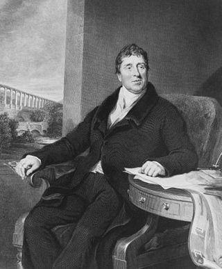
Thomas Telford was a Scottish civil engineer. After establishing himself as an engineer of road and canal projects in Shropshire, he designed numerous infrastructure projects in his native Scotland, as well as harbours and tunnels. Such was his reputation as a prolific designer of highways and related bridges, he was dubbed the Colossus of Roads, and, reflecting his command of all types of civil engineering in the early 19th century, he was elected as the first president of the Institution of Civil Engineers, a post he held for 14 years until his death.
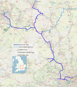
The Grand Union Canal in England is part of the British canal system. It is the principal navigable waterway between London and the Midlands. Starting in London, one arm runs to Leicester and another ends in Birmingham, with the latter stretching for 137 miles (220 km) with 166 locks from London. The Birmingham line has a number of short branches to places including Slough, Aylesbury, Wendover, and Northampton. The Leicester line has two short arms of its own, to Market Harborough and Welford.

The Pontcysyllte Aqueduct is a navigable aqueduct that carries the Llangollen Canal across the River Dee in the Vale of Llangollen in northeast Wales.

William Jessop was an English civil engineer, best known for his work on canals, harbours and early railways in the late 18th and early 19th centuries.

Chirk Aqueduct is a 70-foot (21 m) high and 710-foot (220 m) long navigable aqueduct that carries what is now the Llangollen Canal across the Ceiriog Valley near Chirk, on the England-Wales border, spanning the two countries.

Cosgrove is a village in Northamptonshire, England, about 2 miles (3.2 km) north of Stony Stratford, 6 miles (9.7 km) north of Central Milton Keynes and 12 miles (19.3 km) south of Northampton along the A508 road and 8 miles (12.9 km) south-east of Towcester along the A5 road. The River Tove passes to the east of the village flowing into the River Great Ouse just south, the latter marking the boundary with the City of Milton Keynes in Buckinghamshire. The Grand Union Canal passes through the middle of the village.

Marple Aqueduct at Marple, Greater Manchester, in north-west England was built to carry the lower level of the Peak Forest Canal across the River Goyt.
Navigable aqueducts are bridge structures that carry navigable waterway canals over other rivers, valleys, railways or roads. They are primarily distinguished by their size, carrying a larger cross-section of water than most water-supply aqueducts. Roman aqueducts were used to transport water and were created in Ancient Rome. The 662-metre (2,172 ft) long steel Briare aqueduct carrying the Canal latéral à la Loire over the River Loire was built in 1896. It was ranked as the longest navigable aqueduct in the world for more than a century, until the Magdeburg Water Bridge in Germany took the title in the early 21st century.
The Sankey Viaduct is a railway viaduct in North West England. It is a designated Grade I listed building and has been described as being "the earliest major railway viaduct in the world".
The Buckingham Arm is an English canal that once ran from Cosgrove, Northamptonshire to Buckingham. It was built as an arm of the Grand Junction Canal in two separate phases, a broad canal to Old Stratford, which opened in 1800 and a narrow canal onwards to Buckingham, which opened in 1801. It was disused from 1932, and was dammed at the first bridge in 1944 to reduce leakage from the Grand Union Canal, as the Grand Junction had then become known, but was not finally abandoned until 1964. The remains were severed by the construction of new roads in the 1970s and again in the late 1980s. The section through Old Stratford and Deanshanger was sold off in the 1990s, and the route there has been lost to housing development. The Buckingham Canal Society was formed in 1992, and is actively pursuing a restoration programme. Some 440 yards (400 m) of the canal near Buckingham are now holding water, but the main focus in 2020 was at the Cosgrove end, where a restored channel would be accessible by boat from the Grand Union. Progress was made in September 2023, when 550 yards (500 m) of canal were reopened to navigation.

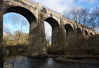
Laigh Milton Viaduct is a railway viaduct near Laigh Milton mill to the west of Gatehead in East Ayrshire, Scotland, about five miles west of Kilmarnock. It is probably the world's earliest surviving railway viaduct on a public railway, and the earliest known survivor of a type of multi-span railway structure subsequently adopted universally.
The Engine Arm Aqueduct near Smethwick, West Midlands, England, was built in 1825 by Thomas Telford to carry a water feeder, the Engine Arm, from Edgbaston Reservoir over the BCN New Main Line canal to the adjacent and parallel Old Main Line. The structure is maintained by the Canal & River Trust. It is a Scheduled Ancient Monument and is Grade II* listed.
George Watson Buck (1789–1854) was the engineer of the Montgomeryshire Canal in the early 19th century, and was responsible for the unique lock paddle design.

The Almond Aqueduct, also known as the Lin's Mill Aqueduct, is a navigable aqueduct that carries the Union Canal over the River Almond in Scotland, west of Ratho, Edinburgh.

The Slateford Aqueduct is a navigable aqueduct that carries the Union Canal over the Water of Leith at Slateford, Edinburgh, Scotland. Completed in 1822, it has eight arches and spans a length of 500 feet (150 m).
The Avon Aqueduct is a navigable aqueduct that carries the Union Canal over the River Avon, near Linlithgow, Scotland.

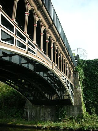
Stretton Aqueduct is a short cast iron canal aqueduct between Stretton and Brewood, and near to Belvide Reservoir, in south Staffordshire, England. Designed by Thomas Telford and bearing his name plus its date of construction, 1832, it carries the Shropshire Union Canal 30 feet (9.1 m) over the A5 road at a skewed angle.
The Barton Aqueduct, opened on 17 July 1761, carried the Bridgewater Canal over the River Irwell at Barton-upon-Irwell, in the historic county of Lancashire, England. Designed largely by James Brindley under the direction of John Gilbert, it was the first navigable aqueduct to be built in England, "one of the seven wonders of the canal age" according to industrial archaeologist Mike Nevell.
Nantwich Aqueduct is a navigable aqueduct in Acton in Cheshire, England, which carries the Shropshire Union Canal over the Chester to Nantwich road. Designed by Thomas Telford, it dates from around 1826 and is listed at grade II*.

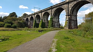
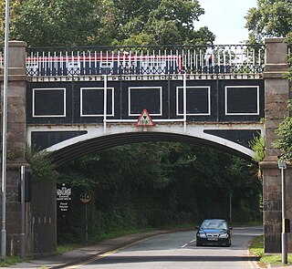
Wolverton Viaduct is a railway bridge carrying the West Coast Main Line over the River Great Ouse to the north of Wolverton, part of Milton Keynes, in south-eastern England. Built in 1838 for the London and Birmingham Railway (L&BR) to the design of Robert Stephenson, it was the largest viaduct on the L&BR's route. It is in the centre of Wolverton Embankment, itself the largest on the line. It has six brick arches and covers a distance of 660 feet, reaching a maximum height of 57 feet above the river, and terminating in substantial abutments which contain decorative arches. The viaduct and embankment feature in drawings by John Cooke Bourne. Several contemporary commentators likened Stephenson's bridges to Roman aqueducts. Some modern engineers and railway historians have suggested that Wolverton Viaduct is not as innovative or impressive as some that followed but nonetheless praised its visual impact.


