County Hall, Llandrindod Wells

Last updated

County Hall, Llandrindod Wells
Powys County Hall, Llandrindod Wells - geograph.org.uk - 190404.jpg
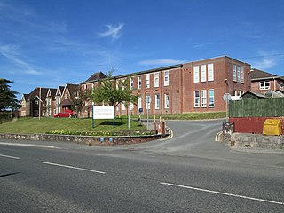
The modern County Hall (on the left) and the old Pump House (on the right)
Powys UK location map.svg
Red pog.svg
County Hall
Location within Powys
General information
Architectural style Postmodern style
Address Llandrindod Wells, Powys
Country United Kingdom
Coordinates 52°14′16″N3°22′23″W / 52.2378°N 3.3730°W / 52.2378; -3.3730
Completed1990

County Hall (Welsh : Neuadd y Sir Llandrindod) is a municipal building in Llandrindod Wells, Wales. It is the headquarters of Powys County Council.

Contents

History

The Pump House Hotel, used by the County Council as their headquarters in the late 1970s and during the 1980s (on the left) and the old Pump House (on the right) Pump House Hotel, Llandrindod Wells.jpg
The Pump House Hotel, used by the County Council as their headquarters in the late 1970s and during the 1980s (on the left) and the old Pump House (on the right)

Following the implementation of the Local Government Act 1888, which established county councils in every county, it became necessary to find a meeting place for Radnorshire County Council: from an early stage the full county council established a tradition of holding its meetings at the Pump House Hotel on Spa Road East in Llandrindod Wells. [1] However, the county council also needed premises for council officers and their departments and established the "County Buildings" in the High Street at Llandrindod Wells in 1909. [2] The county council then moved their staff to larger offices at the former Gwalia Hotel in Ithon Road in 1950. [2] [3]

Following the implementation of the Local Government Act 1972, Radnorshire County Council was abolished and the new Powys County Council decided to acquire the disused Pump House Hotel, not just as their meeting place but for use as their office headquarters as well, in 1974. [4] [a] After the former hotel was found to be structurally unsound, county leaders decided to procure a new building; the site they selected was just to the east of the former hotel but still within its grounds. [5]

The works began with the demolition of the Pump House Hotel: the former pump house itself, where the mineral spring had been used for the treatment of patients, was retained. [7] The new building, which was designed in the Postmodern style as a series of connected pavilions, was officially opened on 27 November 1990. [8]

The county council moved its archives centre off the cramped County Hall site to new premises in Ddole Road in October 2017. [9] It then sought planning permission (from its own planning committee) to expand the capacity of the County Hall complex, by erecting a single storey extension and a new reception hall, in February 2020. [10] [11]

Works of art in County Hall include a portrait of Queen Elizabeth II by Leonard Boden. [12]

Notes

  1. The Pump House Hotel had its origins in an early 18th century farmhouse known as Bach y Craig; after a saline and a sulphur spring was found on the farm in 1736, the medicinal properties of the spring were publicised by a German physician, Diederick Linden, in 1756. [5] After a change of ownership in 1868, the aging hotel was replaced by a modern structure designed by Shepherd & Sons of Cardiff which was completed in 1888. [6] It was used as a military hospital during the Second World War and then became a teacher training college in 1947 before being converted for use as a school for deaf people in 1950 and then falling vacant in 1971. [5]

Related Research Articles

<span class="mw-page-title-main">Powys</span> County and preserved county in Wales

Powys is a county and preserved county in Wales. It borders Gwynedd, Denbighshire, and Wrexham to the north; the English ceremonial counties of Shropshire and Herefordshire to the east; Monmouthshire, Blaenau Gwent, Merthyr Tydfil, Caerphilly, Rhondda Cynon Taf, and Neath Port Talbot to the south; and Carmarthenshire and Ceredigion to the west. The largest settlement is Newtown, and the administrative centre is Llandrindod Wells.

<span class="mw-page-title-main">Radnorshire</span> Historic county of Wales

Radnorshire was an administrative county in mid Wales, later classed as one of the thirteen historic counties of Wales and from 1974 to 1996 a district. It covered a sparsely populated area, and was bounded to the north by Montgomeryshire and Shropshire, to the east by Herefordshire, to the south by Brecknockshire and to the west by Cardiganshire.

<span class="mw-page-title-main">Presteigne</span> Human settlement in Wales

Presteigne is a town and community on the south bank of the River Lugg in Powys, Wales. The town is located on the England–Wales border, which surrounds it to the north, east and south. Nearby towns are Kington, Herefordshire to the south and Knighton to the north, and surrounding villages include Norton and Stapleton. The community has a population of 2,710; the built-up area had a population of 2,056.

<span class="mw-page-title-main">Llandrindod Wells</span> Town in Powys, Wales

Llandrindod Wells is a town and community in Powys, Wales. It serves as the seat of Powys County Council, and is therefore the administrative centre of Powys. The town was historically in Radnorshire.

<span class="mw-page-title-main">Brecon and Radnorshire (UK Parliament constituency)</span> UK Parliamentary constituency, 1918–2024

Brecon and Radnorshire was a county constituency in Wales of the House of Commons of the Parliament of the United Kingdom. Created in 1918, it elected one Member of Parliament (MP) by the first-past-the-post system of election.

<span class="mw-page-title-main">Powys County Council</span> Local government of Powys, Wales

Powys County Council is the local authority for Powys, one of the 22 principal areas of Wales. The council is based at County Hall in Llandrindod Wells.

<span class="mw-page-title-main">Burfa Castle</span>

Burfa Castle is an Iron Age hillfort near the tiny town of Old Radnor, Radnorshire in Powys, Wales. The site is a scheduled monument described as a prehistoric defensive hillfort, and was included in an inventory of monuments by 1913. The site is near Offa's Dyke which passes near the bottom of Burfa Bank.

<span class="mw-page-title-main">Llanbadarn Fawr, Powys</span> Human settlement in Wales

Llanbadarn Fawr is a community in Powys, within the historic boundaries of Radnorshire, mid Wales. Consisting of a tract of undulating land directly north east of Llandrindod Wells, the community consists of the settlements of Crossgates and Fron and in 2001 had a population of 654, increasing to 701 at the 2011 Census. The community name comes from the local church.

Llanbister is a small village and community with a 2011 population of 382 in Powys, mid Wales, in the historic county of Radnorshire. It is on the river Ithon, at the junction of the A483 road and the B4356. It is served by Llanbister Road railway station on the Heart of Wales Line, but the station is some 4 miles east of the village.

<span class="mw-page-title-main">Ysgol Calon Cymru</span> Comprehensive school in Wales

Ysgol Calon Cymru is a bilingual secondary comprehensive school with campuses in Builth Wells and Llandrindod Wells, Powys, mid Wales. It replaced Builth Wells High School and Llandrindod High School and opened at the former schools' sites in September 2018.
<span class="mw-page-title-main">Llandrindod Wells County War Memorial Hospital</span> Hospital in Powys, Wales

Llandrindod Wells County War Memorial Hospital is a health facility in Temple Street, Llandrindod Wells, Powys, Wales. It is managed by the Powys Teaching Health Board.

<span class="mw-page-title-main">Shire Hall, Presteigne</span> County building in Presteigne, Wales

The Shire Hall is a municipal structure in Broad Street, Presteigne, Powys, Wales. The building incorporates a well-preserved courtroom and a museum known as "the Judge's Lodging". Once the judicial centre for Radnorshire, is a Grade II* listed building.

<span class="mw-page-title-main">Llandrindod Wells Library</span> County Building in Llandrindod Wells, Wales

Llandrindod Wells Library, is located in The Gwalia, which is a municipal building on Ithon Road, Llandrindod Wells, Powys, Wales. The structure, which was the headquarters of Radnorshire District Council, is now a customer service point for Powys County Council, and also features a public library. The building is a Grade II listed building.

The Radnorshire Challenge Cup is a football knockout tournament competed for by clubs either based within the Mid-Wales county boundary of Radnorshire or have a team in membership of the Mid Wales South League.

<span class="mw-page-title-main">Old Town Hall, Llandrindod Wells</span> County Building in Llandrindod Wells, Wales

The Old Town Hall is a municipal building in Temple Street, Llandrindod Wells, Powys, Wales. The structure, which accommodates the offices of Llandrindod Wells Town Council, is a Grade II listed building.

<span class="mw-page-title-main">Registered historic parks and gardens in Powys</span> List of buildings in county of Wales

Powys is a county and preserved county in Wales. It covers an area of 5,180 km2 (2,000 sq mi) and in 2021 the population was approximately 133,600.

<span class="mw-page-title-main">Brecon, Radnor and Cwm Tawe (UK Parliament constituency)</span> United Kingdom parliamentary constituency (2024–)

Brecon, Radnor and Cwm Tawe is a constituency of the House of Commons in the UK Parliament, first contested at the 2024 United Kingdom general election, following the 2023 Periodic Review of Westminster constituencies.

Bryndraenog is a timber framed hall house dating from the medieval period in the community of Beguildy, Powys, Wales. It contains examples of wood carving of high quality, and was referenced by the poet Ieuan ap Hywel Swrdwal who called the house "proud maiden of lime and timber". The house is exceptionally well-preserved and is a Grade I listed building.

<span class="mw-page-title-main">St Cewydd's Church, Disserth</span> Church in Powys, Wales

St Cewydd's Church is an active parish church in the village of Disserth, Powys, Wales. The dispersed village of Disserth lies south of Llandrindod Wells and north of Builth Wells. The church stands in an isolated position on a bank of the River Ithon. Unrestored in the Victorian era, the church has an unusually complete 18th century interior. Medieval in origin, St Cewydd's is designated by Cadw as a Grade I listed building.

References

  1. "Radnorshire County Council". Powys: a day in the life. Retrieved 31 October 2020.
  2. 1 2 "County Buildings, Llandrindod Wells". History Points. Retrieved 21 October 2019.
  3. "Gwalia Hotel; Radnor District Council Offices (30680)". Coflein. RCAHMW . Retrieved 21 October 2019.
  4. Whitaker's Almanack 1979, p. 677
  5. 1 2 3 "The Pump House Hotel". Powys Built Heritage. Archived from the original on 24 February 2017. Retrieved 21 October 2019.
  6. "Pump House Hotel (695)". Coflein. RCAHMW. Retrieved 31 October 2020.
  7. "Pump House (408743)". Coflein. RCAHMW. Retrieved 21 October 2019.
  8. "Chief Executive's Department" (PDF). Powys County Council. Retrieved 31 October 2020.
  9. "Archive centre opened by Powys council leader". The Brecon and Radnor Express. 13 October 2017. Retrieved 14 November 2020.
  10. "Erection of a single storey front extension to create a new reception hall and all associated works" (PDF). Powys County Council. 18 December 2019. Retrieved 14 November 2020.
  11. "Powys County Hall extension to go before planning committee". Powys County Times. 5 February 2020. Retrieved 14 November 2020.
  12. Boden, Leonard. "Elizabeth II (b.1926)". Art UK. Retrieved 31 October 2020.[ permanent dead link ]