Credit River, Minnesota

Last updated

Credit River
Scott County Minnesota Incorporated and Unincorporated areas Credit River Highlighted.svg
Location of the city of Credit River
within Scott County, Minnesota
Coordinates: 44°40′26″N93°21′32″W / 44.67389°N 93.35889°W / 44.67389; -93.35889
CountryUnited States
State Minnesota
County Scott
Founded1858
Incorporated May 11, 2021
Government
   Mayor Chris Kostik [ citation needed ]
  CouncilmemberBrent Lawrence
Leroy Schommer
Jay Saterbak
Abe Zanto [ citation needed ]
Area
[1]
  Total23.77 sq mi (61.6 km2)
  Land23.37 sq mi (60.5 km2)
  Water0.4 sq mi (1.11 km2)
Elevation
[2]
935 ft (285 m)
Population
 (2020) [3]
  Total5,493
  Estimate 
(2022) [4]
5,546
  Density218.06/sq mi (84.23/km2)
Time zone UTC-6 (Central)
  Summer (DST) UTC-5 (CDT)
ZIP codes
55044, 55372
Area code 952
FIPS code 27-13726 [5]
GNIS feature ID2830139 [2]
Website creditriver-mn.gov

Credit River is a city in Scott County, Minnesota, United States. The population was 5,493 at the 2020 census. [3]

Contents

History

The former Credit River Township was organized in 1858. [6] The Credit River flows northward through the city. [7] In 2021, it was announced that the township would incorporate as the City of Credit River, following an administrative judge's ruling allowing the incorporation to move forward. The ascension of Credit River to incorporated city status is the first in Minnesota since 2015. [8] Credit River incorporated as a city on May 11, 2021. [9]

Geography

According to the United States Census Bureau, the city has an area of 23.77 square miles (61.6 km2), of which 23.37 square miles (60.5 km2) is land and 0.4 square miles (1.1 km2; 1.72%) is water.

Demographics

Historical population
CensusPop.Note
1860 129
1870 448247.3%
1880 383−14.5%
1890 347−9.4%
1900 45531.1%
1910 446−2.0%
1920 4460.0%
1930 399−10.5%
1940 348−12.8%
1950 39312.9%
1960 43911.7%
1970 1,165165.4%
1980 2,360102.6%
1990 2,85420.9%
2000 3,89536.5%
2010 5,09630.8%
2020 5,4937.8%
2022 (est.)5,546 [4] 1.0%
U.S. Decennial Census [10]
2020 Census [3]

2020 census

As of the census of 2020, there were 5,493 people, 1,842 households.

2010 census

As of the census of 2010, there were 5,096 people.

2000 census

As of the census of 2000, there were 3,895 people, 1,242 households, and 1,105 families residing in the township. The population density was 166.1 inhabitants per square mile (64.1/km2). There were 1,252 housing units at an average density of 53.4/sq mi (20.6/km2). The racial makeup of the township was 98.18% White, 0.28% African American, 0.28% Native American, 0.74% Asian, 0.10% from other races, and 0.41% from two or more races. Hispanic or Latino of any race were 0.56% of the population.

There were 1,242 households, out of which 48.3% had children under the age of 18 living with them, 81.7% were married couples living together, 3.7% had a female householder with no husband present, and 11.0% were non-families. 7.7% of all households were made up of individuals, and 1.0% had someone living alone who was 65 years of age or older. The average household size was 3.13 and the average family size was 3.29.

In the township the population was spread out, with 31.6% under the age of 18, 6.0% from 18 to 24, 31.0% from 25 to 44, 27.4% from 45 to 64, and 4.0% who were 65 years of age or older. The median age was 37 years. For every 100 females, there were 103.2 males. For every 100 females age 18 and over, there were 106.7 males.

The median income for a household in the township was $78,501, and the median income for a family was $79,852. Males had a median income of $55,739 versus $38,000 for females. The per capita income for the township was $29,567. About 2.2% of families and 3.1% of the population were below the poverty line, including 5.7% of those under age 18 and 2.6% of those age 65 or over.

See also

Related Research Articles

Runeberg Township is a township in Becker County, Minnesota, United States. The population was 387 as of the 2000 census.

Boy River Township is a township in Cass County, Minnesota, United States. The population was 100 as of the 2000 census. This township took its name from the Boy River.

Pine River Township is a township in Cass County, Minnesota, United States. The population was 1,061 as of the 2000 census. This township took its name from the Pine River.

Vermillion Township is a township in Dakota County, Minnesota, United States. The population was 1,243 at the 2000 census.

Florence Township is a township in Goodhue County, Minnesota, United States. The population was 1,450 at the 2000 census. A small part of the city of Lake City extends geographically within the township, but is a separate entity. The unincorporated area of Frontenac is also located within the township.

Oronoco Township is a township in Olmsted County, Minnesota, United States. The population was 2,239 at the 2000 census. The township was organized in 1858 and named for the adjacent city of Oronoco, which had formed in 1854. The city was named by early settler Dr. Hector Galloway for the similarly spelled Orinoco, a large river in South America.

Kettle River Township is a township in Pine County, Minnesota, United States. The population was 491 at the 2000 census.

<span class="mw-page-title-main">Granite Rock Township, Redwood County, Minnesota</span> Township in Minnesota, United States

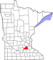
Granite Rock Township is one of the twenty-six townships of Redwood County, Minnesota, United States. The population was 241 at the 2000 census.

Alborn Township is a township in Saint Louis County, Minnesota, United States. At the 2010 census, the population was 460.

<span class="mw-page-title-main">Biwabik Township, St. Louis County, Minnesota</span> Township in Minnesota, United States

Biwabik Township is a township in Saint Louis County, Minnesota, United States. Biwabik is a name derived from the Ojibwe language meaning "iron". The population was 804 at the 2010 census.

Culver Township is a township in Saint Louis County, Minnesota, United States. The population was 294 at the 2010 census.

Lavell Township is a township in Saint Louis County, Minnesota, United States. The population was 303 at the 2010 census.

McDavitt Township is a township in Saint Louis County, Minnesota, United States. The population was 459 at the 2010 census.

Prairie Lake Township is a township in Saint Louis County, Minnesota, United States. The population was 50 at the 2010 census.

Van Buren Township is a township in Saint Louis County, Minnesota, United States. It was named for Martin Van Buren, the eighth President of the United States. The population was 189 at the 2010 census.

Waasa Township is a township in Saint Louis County, Minnesota, United States. The population was 249 at the 2010 census.

Wuori Township is a township in Saint Louis County, Minnesota, United States. The population was 572 at the 2010 census.

<span class="mw-page-title-main">Wyalusing Township, Bradford County, Pennsylvania</span> Township in Pennsylvania, United States

Wyalusing Township is a township in Bradford County, Pennsylvania. It is part of Northeastern Pennsylvania. The population was 1,242 at the 2010 census.

<span class="mw-page-title-main">Pequea Township, Lancaster County, Pennsylvania</span> Township in Pennsylvania, United States

Pequea Township is a township that is located in central Lancaster County, Pennsylvania, United States. The population was 5,493 at the time of the 2020 census.

<span class="mw-page-title-main">Penn Township, Perry County, Pennsylvania</span> Township in Pennsylvania, United States

Penn Township is a township in Perry County, Pennsylvania, United States. The population was 3,112 at the 2020 census.

References

  1. "2020 U.S. Gazetteer Files". United States Census Bureau. Retrieved July 24, 2022.
  2. 1 2 U.S. Geological Survey Geographic Names Information System: Credit River, Minnesota
  3. 1 2 3 "Explore Census Data". United States Census Bureau . Retrieved June 3, 2023.
  4. 1 2 "City and Town Population Totals: 2020-2022". United States Census Bureau. June 3, 2023. Retrieved June 3, 2023.
  5. "U.S. Census website". United States Census Bureau . Retrieved January 31, 2008.
  6. Upham, Warren (1920). Minnesota Geographic Names: Their Origin and Historic Significance. Minnesota Historical Society. p.  508.
  7. Minnesota Atlas & Gazetteer. Yarmouth, Maine: DeLorme. 1994. p. 33. ISBN   0-89933-222-6.
  8. Nelson, Joe. "For 1st time since 2015, a Minnesota township will become a city". Bring Me The News. Retrieved February 2, 2021.
  9. "Credit River residents elect mayor, City Council members". Sun Thisweek. Adams Publishing Group. Retrieved May 14, 2021.
  10. United States Census Bureau. "Census of Population and Housing" . Retrieved September 11, 2013.