
Onkaparinga River National Park is a protected area in the Australian state of South Australia located about 32 kilometres (20 mi) south of Adelaide city centre. It extends over the floodplain of the Onkaparinga River east of Main South Road.

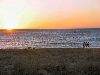
The River Torrens is the most significant river of the Adelaide Plains. It was one of the main reasons for the siting of the city of Adelaide, capital of South Australia. It flows 85 kilometres (53 mi) from its source in the Adelaide Hills near Mount Pleasant, across the Adelaide Plains, past the city centre and empties into Gulf St Vincent between Henley Beach South and West Beach. The upper stretches of the river and the reservoirs in its watershed supply a significant part of the city's water supply.

Belair is a suburb in the south eastern foothills of Adelaide, South Australia at the base of the Mount Lofty Ranges.

Adelaide Hills Council is a local government area in the Adelaide Hills of South Australia. It is in the hills east of Adelaide, the capital of South Australia. It extends from the South Para Reservoir in the north, to the Mount Bold Reservoir in the south.

Birdwood is a town near Adelaide, South Australia. It is located in the local government areas of the Adelaide Hills Council and the Mid Murray Council.

The Adelaide Park Lands comprise the figure-eight configuration of land, spanning both banks of the River Torrens between Hackney and Thebarton, which encloses and separates the City of Adelaide area from the surrounding suburbia of greater metropolitan Adelaide, the capital city of South Australia. They were laid out by Colonel William Light in his design for the city, and originally consisted of 2,300 acres (930 ha) "exclusive of 32 acres (13 ha) for a public cemetery". One copy of Light's plan shows areas for a cemetery and a Post and Telegraph Store on West Terrace, a small Government Domain and Barracks on the central part of North Terrace, a hospital on East Terrace, a Botanical Garden on the River Torrens west of North Adelaide, and a school and a storehouse south-west of North Adelaide.
Waterfall Gully is an eastern suburb of the South Australian capital city of Adelaide. It is located in the foothills of the Mount Lofty Ranges around 5 km (3.1 mi) east-south-east of the Adelaide city centre. For the most part, the suburb encompasses one long gully with First Creek at its centre and Waterfall Gully Road running adjacent to the creek. At the southern end of the gully is First Falls, the waterfall for which the suburb was named. Part of the City of Burnside, Waterfall Gully is bounded to the north by the suburb of Burnside, from the north-east to south-east by Cleland National Park, to the south by Crafers West, and to the west by Leawood Gardens and Mount Osmond.

Marble Hill was the Vice-Regal summer residence for the Governor of South Australia for seventy-five years, from 1880 to 1955. It is also the name of a ward of the Adelaide Hills Council, and a suburb, both named after the residence and in which the residence is located. It is about 20 kilometres (12 mi) east of Adelaide between the towns of Ashton and Cherryville, and has expansive views of the Adelaide Hills to the North and East, and the Adelaide Plains to the West.

Magill is a suburb of Adelaide straddling the City of Burnside and City of Campbelltown council jurisdictions, approximately 7 km east of the Adelaide CBD. It incorporates the suburb previously known as Koongarra Park.

Lobethal is a town in the Adelaide Hills area of South Australia. It is located in the Adelaide Hills Council local government area, and is nestled on the banks of a creek between the hills and up the sides of the valley. It was once the centre of the Adelaide Hills wool processing industry, which continued until around 1950. The mill buildings are now used by a number of cottage industry and handcraft businesses. At the 2016 census, Lobethal had a population of 2,135.

Morialta is a single-member electoral district for the South Australian House of Assembly. It is a 356 km2 electorate stretching from the Adelaide Hills to the outer eastern and north-eastern suburbs of Adelaide, taking in the suburbs and localities of Auldana, Ashton, Athelstone, Basket Range, Birdwood, Castambul, Cherryville, Cudlee Creek, Forest Range, Gumeracha, Highbury, Kenton Valley, Lenswood, Lobethal, Marble Hill, Montacute, Mount Torrens, Norton Summit, Rostrevor, Summertown, Teringie, Uraidla and Woodforde, as well as part of Chain of Ponds.

Campbelltown is a north-eastern suburb of Adelaide, South Australia. The population of the area was 7,003 in 2006. It is bordered in the north-west by the River Torrens, a river that is surrounded by parks and smaller creeks. Campbelltown is 8.7 km north-east of Adelaide. Lower North East Road crosses the middle of the suburb.
Seacliff is a coastal suburb located in the capital city of South Australia; Adelaide. Overseen by the council, City of Holdfast Bay, this suburb is adjacent to South Brighton, Seacliff Park, Marino and Kingston Park.
Paracombe is a small town near Adelaide, South Australia. At the 2011 census, Paracombe had a population of 343.

Gumeracha is a town in the Adelaide Hills, South Australia, located on the Adelaide-Mannum Road. It is located in the Adelaide Hills Council local government area on the south bank of the upper River Torrens. At the 2006 census, Gumeracha had a population of 731.

Mount Torrens is a town in the eastern Adelaide Hills region of South Australia, 46 kilometres east-north-east of the state capital, Adelaide and 8 km east of Lobethal. It is located in the Adelaide Hills Council and the Mid Murray Council local government areas. At the 2006 census, Mount Torrens had a population of 337.

Adelaide city centre is the inner city locality of Greater Adelaide, the capital city of South Australia. It is known by locals simply as "the City" or "Town" to distinguish it from Greater Adelaide and from the City of Adelaide local government area. The population was 15,115 in the 2016 census.
The Sturt River, also known as the Sturt Creek and Warri Parri (Warriparri) in the Kaurna language, is a river located in the Adelaide region of the Australian state of South Australia.

Basket Range is a small town in the Adelaide Hills, South Australia. It is located on an approximately north–south ridge that runs from Deep Creek in the north to Greenhill Road in the south. The area is completely encircled by hills, giving the town the appearance of nestling within a large basket, hence "Basket Range".
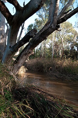
Cudlee Creek Conservation Park is a protected area located in the Australian state of South Australia in the locality of Cudlee Creek in the Adelaide Hills state government region about 12 kilometres (7.5 mi) south-east of the state capital of Adelaide and about 4 kilometres (2.5 mi) south-west of the town centre in Gumeracha.


