Cuyuní River

Last updated

Cuyuni River
Essequiborivermap.png
Location
Country Venezuela and Guyana
Physical characteristics
Source 
  location Guiana Highlands, Venezuela
  coordinates 6°2′5.0316″N61°36′34.1388″W / 6.034731000°N 61.609483000°W / 6.034731000; -61.609483000
  elevation399 m (1,309 ft)
Mouth Essequibo
  location
Bartica, Guyana
  coordinates
6°24′28″N58°37′18″W / 6.40778°N 58.62167°W / 6.40778; -58.62167
  elevation
1 m (3 ft 3 in)
Length618 km (384 mi)
Basin size85,635 km2 (33,064 sq mi) [1]
Discharge 
  location Bartica, Guyana (near mouth)
  average85.808 km3/a (2,719.1 m3/s) [2] (Period: 1971–2000)2,674.2 m3/s (94,440 cu ft/s) [3]
Discharge 
  locationKamaria Falls (Basin size: 53,354 km2 (20,600 sq mi)
  average1,360 m3/s (48,000 cu ft/s) [4]
Discharge 
  location Anacoco
  average719.5 m3/s (25,410 cu ft/s) [4]
Discharge 
  location El Dorado, Venezuela
  average(Period: 1971–2000)503.8 m3/s (17,790 cu ft/s) [3]
Basin features
Progression EssequiboAtlantic Ocean
Tributaries 
  left Yuruarí, Corumpo
  right Wenamu, Mazaruni

The Cuyuni River is a South American river and a tributary of the Essequibo River. It rises in the Guiana Highlands of Venezuela, where it descends northward to El Dorado, and turns eastward to meander through the tropical rain forests of the Cuyuni-Mazaruni Region of Guyana. It finally turns southeastward, flowing to its confluence with the Mazaruni River.

Contents

The Cuyuni River marks a border in the Guyana–Venezuela territorial dispute for approximately 100 kilometres (62 mi).

Makarapan Mountain is a sandstone range by the Cuyuni. [5]

History

In 1681, an island in the mouth of the Cuyuni River was cleared and planted with cassava for the use of the Dutch garrison. By 1694, a new plantation on the Cuyuni River above the fort was established. By 1703 a post was established on the Pariacot Savannah, in the upper Cuyuni.

On January 2, 1895, the "Incident of the Cuyuni river", so named by the general Domingo Antonio Sifontes  [ es ], was an armed confrontation between Venezuelans and British in the region of the river over the territorial dispute between Venezuela and British Guyana, which under Sifontes the Venezuelans left winners.

Inspector Barnes in the Venezuelan station. English Station on the Cuyuni River.jpg
Inspector Barnes in the Venezuelan station.

At dawn, British policemen led by an Inspector Barnes of England took an unoccupied military station of Venezuelan nationality, located on the left bank of the river. Barnes’ men hoisted the British flag during the day.

Captain Andrés Avelino Domínguez, second in command of Sifontes, was sent to recover the settlement. The result was the withdrawal of the British and the capture of Barnes and his men, who were taken to the General Police Station, which increased tensions between the two countries amid an internal crisis in Venezuela. [6]

Settlement

The river is a source of alluvial gold and attracts mining in the form of dredging. Illegal mining also occurs on the river banks, [7] and mining also has exacerbated the border issue between Guyana and Venezuela. [8]

Large-scale mining operation Aurora gold mine is on the Cuyuni River. [9]

Development of a hydroelectric power site is under consideration at Kamaria on the Cuyuni River. [10]

Venezuela

El Dorado is a Venezuelan settlement on the Cuyuni River. [11]

Guyana

Some of the Kali'na people live in the Cuyuni River valley, part of which is in Guyana.

Eteringbang is a border settlement [12] with an airstrip. [13] Saint Martin and Ankoko Island have been the subject of further disputes between Venezuela and Guyana. In 2015, GDF forces continued observation from Eteringbang and Kaikan and other points along the river. [14]

The town of Bartica is close to the mouth of the Cuyuni where it meets with the confluence of Essequibo and Mazaruni rivers. [15]

See also

Related Research Articles

The transport sector comprises the physical infrastructure, docks and vehicle, terminals, fleets, ancillary equipment and service delivery of all the various modes of transport operating in Guyana. The transport services, transport agencies providing these services, the organizations and people who plan, build, maintain, and operate the system, and the policies that mold its development.

<span class="mw-page-title-main">Essequibo River</span> Major river in Guyana

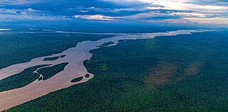
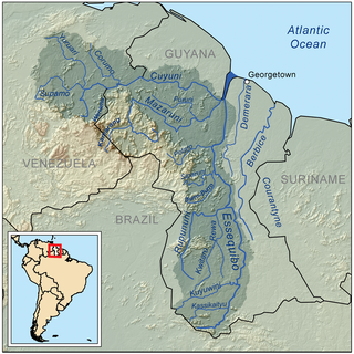
The Essequibo River is the largest river in Guyana, and the largest river between the Orinoco and Amazon. Rising in the Acarai Mountains near the Brazil–Guyana border, the Essequibo flows to the north for 1,014 km (630 mi) through forest and savanna into the Atlantic Ocean. It has a total drainage basin of 156,828 km2 (60,552 sq mi) and an average discharge of 5,650 m3/s (200,000 cu ft/s).

<span class="mw-page-title-main">Bartica</span> Town and regional capital in Cuyuni-Mazaruni, Guyana

Bartica, Essequibo, is a town on the left bank of the Essequibo River in Cuyuni-Mazaruni, at the confluence of the Cuyuni and Mazaruni Rivers with the Essequibo River in Guyana. It is the regional capital of Cuyuni-Mazaruni.

<span class="mw-page-title-main">Barima-Waini</span> Region of Guyana

Barima-Waini is a region of Guyana and is located in the northwest of the country. Barima-Waini has three sub-regions: Mabaruma, Matakai, and Moruca.

<span class="mw-page-title-main">Cuyuni-Mazaruni</span> Region of Guyana

Cuyuni-Mazaruni is a region of Guyana. Its capital is Bartica, with villages including Issano, Kartabo, Kamarang, and Imbaimadai.

<span class="mw-page-title-main">Mazaruni River</span> River in Guyana

The Mazaruni River is a tributary of the Essequibo River in northern Guyana. Its source is in the remote western forests of the Pakaraima Mountains and its confluence with the Cuyuni River is near Bartica. As it descends from the Guiana Highlands the river runs south-east, past Issano, then northward to Bartica. The river is a source of alluvial gold.

<span class="mw-page-title-main">Potaro-Siparuni</span> Region of Guyana

Potaro-Siparuni is a region of Guyana. It borders the region of Cuyuni-Mazaruni to the north, the regions of Upper Demerara-Berbice and East Berbice-Corentyne to the east, the region of Upper Takutu-Upper Essequibo to the south and Brazil to the west.

<span class="mw-page-title-main">Essequibo (colony)</span> 1616–1803 Dutch colony in South America

Essequibo was a Dutch colony in the Guianas and later a county on the Essequibo River in the Guiana region on the north coast of South America. It was a colony of the Dutch West India Company between 1616 and 1792 and a colony of the Dutch state from 1792 until 1815. It was merged with Demerara in 1812 by the British who took control. It formally became a British colony in 1815 until Demerara-Essequibo was merged with Berbice to form the colony of British Guiana in 1831. In 1838, it became a county of British Guiana till 1958. In 1966, British Guiana gained independence as Guyana and in 1970 it became a republic as the Co-operative Republic of Guyana. It was located around the lower course of the Essequibo River.

<span class="mw-page-title-main">Ankoko Island</span> Island located at the confluence of the Cuyuni River and Wenamu River

Ankoko Island is an island located at the confluence of the Cuyuni River and Wenamu River, at 6°43′N61°8′W, on the border between Venezuela and Guyana.

Kurupung is a mining community in the Cuyuni-Mazaruni Region of Guyana, near the Pakaraima Mountains.

<span class="mw-page-title-main">Guyana–Venezuela territorial dispute</span> Territorial dispute between Guyana and Venezuela

The Guyana–Venezuela territorial dispute is an ongoing territorial dispute between Guyana and Venezuela over the Essequibo region, also known as Esequibo or Guayana Esequiba in Spanish, a 159,500 km2 (61,600 sq mi) area west of the Essequibo River. The territory, excluding the Venezuelan-controlled Ankoko Island, is controlled by Guyana as part of six of its regions, based on the 1899 Paris Arbitral Award. It is also claimed by Venezuela as the Guayana Esequiba State. The boundary dispute was inherited from the colonial powers and has persisted following the independence of Venezuela and Guyana.

El Dorado is a small town in eastern Venezuela. It is situated in Bolívar State, on the Cuyuni River. It is the second-largest town in Sifontes Municipality; the capital of the municipality is Tumeremo.

<span class="mw-page-title-main">Guyana–Venezuela relations</span> Bilateral relations

Guyana–Venezuela relations include diplomatic, economic and other interactions between the neighboring countries of the Co-operative Republic of Guyana and the Bolivarian Republic of Venezuela.

<span class="mw-page-title-main">Wenamu River</span> River in Venezuela and Guyana

Wenamu River is a river in South America. It forms a portion of the international boundary between Venezuela and Guyana. It is part of the Essequibo River basin.

The Kako River is a river in the Cuyuni-Mazaruni region of Guyana and one of the largest tributaries of the Mazaruni River.

The Ekareku River is a river of Guyana, a tributary of the Wenamu River.

The Bartica Massacre refers to the murder of twelve residents of Bartica, Cuyuni-Mazaruni, Guyana, murdered by the criminal gang led by Rondell "Fineman" Rawlins. Rawlins and many of the other suspected gang members were later killed by Guyanese security forces. This massacre was part of a series of murders that appeared to have begun with the Mash Day Prison break.

Issano is a village of Cuyuni-Mazaruni, Guyana. It's located along the Mazaruni River, and is a hub for mining.

Isseneru is an Amerindian settlement in the Cuyuni-Mazaruni region of Guyana, approximately 15–20 miles west of Kurupung.

Agatash is a village in the Cuyuni-Mazaruni Region of Guyana. It is located about 3 miles (4.8 km) south of Bartica along the Essequibo River opposite Sloth Island.

References

  1. A.Y., Hoekstra; M.M., Mekonnen (September 2011). "GLOBAL WATER SCARCITY: THE MONTHLY BLUE WATER FOOTPRINT COMPARED TO BLUE WATER AVAILABILITY FOR THE WORLD'S MAJOR RIVER BASINS - VALUE OF WATER RESEARCH REPORT SERIES NO.53" (PDF).
  2. A.Y., Hoekstra; M.M., Mekonnen (September 2011). "GLOBAL WATER SCARCITY: THE MONTHLY BLUE WATER FOOTPRINT COMPARED TO BLUE WATER AVAILABILITY FOR THE WORLD'S MAJOR RIVER BASINS-VALUE OF WATER RESEARCH REPORT SERIES NO.53" (PDF).
  3. 1 2 "Atlantic North Coast".
  4. 1 2 Faustino, Morales (1999). GEOGRAFÍA FÍSICA DEL TERRITORIO EN RECLAMACIÓN GUYANA ESEQUIBA. ISBN   980-00-1617-1.
  5. "Earth matters…". Guyana Chronicle. Retrieved January 19, 2021.
  6. "Domingo Sifontes, el venezolano que hizo correr a los ingleses". June 12, 2015.
  7. "Brazilian dredge owner fined $12m for ripping up part of Cuyuni River bank". Stabroek News. September 15, 2020. Retrieved January 19, 2021.
  8. "Venezuela 'regrets' incursion". Stabroek News. December 13, 2007. Retrieved January 19, 2021.
  9. "Guyana Goldfields again assures over cyanide safety". Stabroek News. December 11, 2015. Retrieved January 19, 2021.
  10. "Government assessing multiple green energy options- to fuel Guyana's Development". Department of Public Information. October 26, 2016. Retrieved January 19, 2021.
  11. Herman, Marc (December 18, 2007). Searching for El Dorado: A Journey into the South American Rainforest on the Tail of the World's Largest Gold Rush. Knopf Doubleday Publishing Group. ISBN   978-0-307-42765-6.
  12. "First time school for Eteringbang". Department of Public Information. September 10, 2019. Retrieved January 19, 2021.
  13. "Several airstrips' upgrade underway- additional hubs to be created". Department of Public Information. May 18, 2016. Retrieved January 19, 2021.
  14. "Jamaica Observer Limited". Jamaica Observer. Retrieved January 19, 2021.
  15. "Bartica | Guyana". Encyclopedia Britannica. Retrieved January 19, 2021.

6°23′N58°41′W / 6.383°N 58.683°W / 6.383; -58.683