The Azores, officially the Autonomous Region of the Azores, is one of the two autonomous regions of Portugal. It is an archipelago composed of nine volcanic islands in the Macaronesia region of the North Atlantic Ocean, about 1,400 km (870 mi) west of Lisbon, about 1,500 km (930 mi) northwest of Morocco, and about 1,930 km (1,200 mi) southeast of Newfoundland, Canada.

Madeira, officially the Autonomous Region of Madeira, is one of two autonomous regions of Portugal, the other being the Azores. It is an archipelago situated in the North Atlantic Ocean, in a region known as Macaronesia, just under 400 kilometres (250 mi) to the north of the Canary Islands and 520 kilometres (320 mi) west of the Kingdom of Morocco. Madeira is geologically located on the African Tectonic Plate, notwithstanding being culturally, sociologically, economically and politically European as is its southern archipelago neighbor. Its population was 251,060 in 2021. The capital of Madeira is Funchal, which is located on the main island's south coast.

Saint Helena is a British overseas territory located in the South Atlantic Ocean. It is a remote volcanic tropical island 1,950 kilometres west of the coast of south-western Africa, and 4,000 kilometres (2,500 mi) east of Rio de Janeiro in South America. It is one of three constituent parts of the British Overseas Territory of Saint Helena, Ascension and Tristan da Cunha.
Tristan da Cunha, colloquially Tristan, is a remote group of volcanic islands in the South Atlantic Ocean. It is the most remote inhabited archipelago in the world, lying approximately 2,787 kilometres (1,732 mi) from Cape Town in South Africa, 2,437 kilometres (1,514 mi) from Saint Helena and 4,002 kilometres (2,487 mi) from the Falkland Islands.

Vasco da Gama, 1st Count of Vidigueira, was a Portuguese explorer and the first European to reach India by sea.
Tristan da Cunha is part of the British overseas territory of Saint Helena, Ascension and Tristan da Cunha and has a history going back to the beginning of the 16th century. It was settled by men from military garrisons and ships, who married native women from Saint Helena and the Cape Colony. Its people are multi-racial, descended from European male founders and mixed-race and African women founders.

Funchal is the largest city, the municipal seat and the capital of Portugal's Autonomous Region of Madeira, bordered by the Atlantic Ocean. The city has a population of 105,795, making it the sixth largest city in Portugal. Because of its high cultural and historical value, Funchal is one of Portugal's main tourist attractions; it is also popular as a destination for New Year's Eve, and it is the leading Portuguese port on cruise liner dockings.

The British Overseas Territories (BOTs), also known as the United Kingdom Overseas Territories (UKOTs), are fourteen territories with a constitutional and historical link with the United Kingdom. They are the last remnants of the former British Empire and do not form part of the United Kingdom itself. The permanently inhabited territories are internally self-governing, with the United Kingdom retaining responsibility for defence and foreign relations. Three of the territories are inhabited only by a transitory population of military or scientific personnel. All but one of the rest are listed by the UN Special Committee on Decolonization as non-self-governing territories. All fourteen have the British monarch as head of state.

Florianópolis is the capital and second largest city of the state of Santa Catarina, in the South region of Brazil. The city encompasses Santa Catarina Island and surrounding small islands, as well as part of the mainland. It has a population of 508,826, according to the 2020 IBGE population estimate, the second-most populous city in the state, and the 47th in Brazil. The metropolitan area has an estimated population of 1,111,702, the 21st largest in the country. The city is known for having the country's third highest Human Development Index score among all Brazilian cities (0.847).
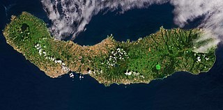
São Miguel Island, nicknamed "The Green Island", is the largest and most populous island in the Portuguese archipelago of the Azores. The island covers 760 km2 (290 sq mi) and has around 140,000 inhabitants, with 45,000 people residing in Ponta Delgada, the archipelago's largest city.

Príncipe is the smaller, northern major island of the country of São Tomé and Príncipe lying off the west coast of Africa in the Gulf of Guinea. It has an area of 142 square kilometres (55 sq mi) and a population of 7,324 at the 2012 Census; the latest official estimate was 8,420. The island is a heavily eroded volcano speculated to be over three million years old, surrounded by smaller islands including Ilheu Bom Bom, Ilhéu Caroço, Tinhosa Grande and Tinhosa Pequena. Part of the Cameroon Line archipelago, Príncipe rises in the south to 947 metres at Pico do Príncipe. The island is the main constituent of the Autonomous Region of Príncipe, established in 1995, and of the coterminous district of Pagué.

Terceira is a volcanic island in the Azores archipelago, in the middle of the North Atlantic Ocean. It is one of the larger islands of the archipelago, with a population of 53,311 inhabitants in an area of approximately 396.75 square kilometres. It is the location of the Azores' oldest city, Angra do Heroísmo, the historical capital of the archipelago and UNESCO World Heritage Site; the seat of the judicial system ; and the main Air Force base, Base Aérea nº 4 at Lajes, with a United States Air Force detachment.

The Scattered Islands in the Indian Ocean consist of four small coral islands, an atoll, and a reef in the Indian Ocean, and have constituted the 5th district of the French Southern and Antarctic Lands (TAAF), though sovereignty over some or all of the Islands is contested by Madagascar, Mauritius, and the Comoros. None of the islands have ever had a permanent population.

Inaccessible Island is a volcanic island located in the South Atlantic Ocean, 31 km (19 mi) south-west of Tristan da Cunha. Its highest point, Cairn Peak, reaches 449 m (1,473 ft), and the island is 12.65 km2 (4.88 sq mi) in area. The volcano was last active six million years ago and is currently extinct.

The Governor of Saint Helena is the representative of the British monarch in the United Kingdom's overseas territory of Saint Helena, Ascension and Tristan da Cunha. The Governor is appointed by the monarch on the official advice of His Majesty's Government (HMG).
The Nightingale Islands are a group of three islands in the South Atlantic Ocean, part of the Tristan da Cunha territory. They consist of Nightingale Island, Middle Island and Stoltenhoff Island. The islands are administered by the United Kingdom as part of the overseas territory of Saint Helena, Ascension and Tristan da Cunha. The Nightingale Islands are uninhabited.

Ascension Island is an isolated volcanic island, 7°56′ south of the Equator in the South Atlantic Ocean. It is about 1,000 miles (1,600 km) from the coast of Africa and 1,400 miles (2,300 km) from the coast of South America. It is governed as part of the British Overseas Territory of Saint Helena, Ascension and Tristan da Cunha, of which the main island, Saint Helena, is around 800 miles (1,300 km) to the southeast. The territory also includes the sparsely populated Tristan da Cunha archipelago, 2,300 miles (3,700 km) to the south, about halfway to the Antarctic Circle.

Saint Helena, Ascension and Tristan da Cunha is a British Overseas Territory located in the South Atlantic and consisting of the island of Saint Helena, Ascension Island and the archipelago of Tristan da Cunha including Gough Island. Its name was Saint Helena and Dependencies until 1 September 2009, when a new constitution came into force giving the three islands equal status as three territories, with a grouping under the Crown.

Native languages of Oceania fall into three major geographic groups:

The Barbado da Terceira is Portuguese breed of herding and guard dog from the Atlantic island of Terceira in the Azores, for which it is named. It was recognised by the Direcção-Geral de Veterinária of Portugal in 2004. It is not recognised by the Fédération Cynologique Internationale.