Dannes | |
|---|---|
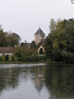 The church of Dannes | |
 Coat of arms | |
Location of Dannes  | |
 Dannes  Dannes | |
| Coordinates: 50°35′24″N1°36′53″E / 50.59°N 1.6147°E | |
| Country | France |
| Region | Hauts-de-France |
| Department | Pas-de-Calais |
| Arrondissement | Boulogne-sur-Mer |
| Canton | Outreau |
| Intercommunality | CA du Boulonnais |
| Government | |
| • Mayor (2020–2026) | Olivier Carton [1] |
Area 1 | 10.23 km2 (3.95 sq mi) |
| Population (2022) [2] | 1,317 |
| • Density | 130/km2 (330/sq mi) |
| Time zone | UTC+01:00 (CET) |
| • Summer (DST) | UTC+02:00 (CEST) |
| INSEE/Postal code | 62264 /62187 |
| Elevation | 4–160 m (13–525 ft) (avg. 30 m or 98 ft) |
| 1 French Land Register data, which excludes lakes, ponds, glaciers > 1 km2 (0.386 sq mi or 247 acres) and river estuaries. | |
Dannes (French pronunciation: [dan] ) is a commune in the Pas-de-Calais department in the Hauts-de-France region of France [3] about 13 kilometres (8.1 mi) south of Boulogne on the shore of the English Channel.