Wimereux

Last updated • 1 min readFrom Wikipedia, The Free Encyclopedia

Wimereux
Wimeruwe
Wimereux rogne1.jpg
Wimereux
Blason Wimereux.svg
Location of Wimereux
Wimereux
France location map-Regions and departements-2016.svg
Red pog.svg
Wimereux
Hauts-de-France region location map.svg
Red pog.svg
Wimereux
Coordinates: 50°46′N1°37′E / 50.77°N 1.61°E / 50.77; 1.61
Country France
Region Hauts-de-France
Department Pas-de-Calais
Arrondissement Boulogne-sur-Mer
Canton Boulogne-sur-Mer-1
Intercommunality Boulonnais
Government
  Mayor (20202026) Jean-Luc Dubaële [1]
Area
1
7.71 km2 (2.98 sq mi)
Population
 (2021) [2]
6,358
  Density820/km2 (2,100/sq mi)
Time zone UTC+01:00 (CET)
  Summer (DST) UTC+02:00 (CEST)
INSEE/Postal code
62893 /62930
Elevation0–71 m (0–233 ft)
1 French Land Register data, which excludes lakes, ponds, glaciers > 1 km2 (0.386 sq mi or 247 acres) and river estuaries.

Wimereux (French: [vim(ə)ʁø] ; West Flemish : Wimeruwe) is a commune in the Pas-de-Calais department in the Hauts-de-France region of France [3] 5 kilometres (3 mi) north of Boulogne-sur-Mer, on the banks of the small river Wimereux. The river Slack forms the northern border of the commune and the English Channel the western.

Contents

History

In March 1899 the first radio link between France and England was established at Wimereux by Guglielmo Marconi. [4]

Lady Hadfield set up and ran a Red Cross hospital there. [5] The Women's Hospital Corps, founded by Flora Murray and Louisa Garratt Anderson, opened its second hospital in Wimereux. It was the first women's hospital to be recognised by the British Army. [6] In 1916, Solomon J Solomon set up a Royal Engineers establishment, the Special Works Park, in a disused feldspar factory and developed new military camouflage techniques and equipment for the British Army. [7]

People

Twin towns

Wimereux is twinned with the following towns:

Population

Historical population
YearPop.±% p.a.
1968 5,241    
1975 6,712+3.60%
1982 7,023+0.65%
1990 7,109+0.15%
1999 7,493+0.59%
2007 7,398−0.16%
2012 7,161−0.65%
2017 6,575−1.69%
Source: INSEE [9]

See also

Related Research Articles

<span class="mw-page-title-main">Boulogne-sur-Mer</span> Subprefecture and commune in Hauts-de-France, France

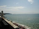
Boulogne-sur-Mer, often called just Boulogne, is a coastal city in Northern France. It is a sub-prefecture of the department of Pas-de-Calais. Boulogne lies on the Côte d'Opale, a touristic stretch of French coast on the English Channel between Calais and Normandy, and the most visited location in the region after the Lille conurbation. Boulogne is its department's second-largest city after Calais, and the 183rd-largest in France. It is also the country's largest fishing port, specialising in herring.

<span class="mw-page-title-main">Cambrin</span> Commune in Hauts-de-France, France

Cambrin is a commune in the Pas-de-Calais department in the Hauts-de-France region of France about 5 miles (8.0 km) east of Béthune and 18 miles (29 km) southwest of Lille by the banks of the small river Surgeon.

<span class="mw-page-title-main">Dainville</span> Commune in Hauts-de-France, France

Dainville is a commune in the Pas-de-Calais department in the Hauts-de-France region of France 2 miles (3.2 km) west of Arras..

<span class="mw-page-title-main">Loos-en-Gohelle</span> Commune in Hauts-de-France, France

Loos-en-Gohelle is a commune in the Pas-de-Calais department in the Hauts-de-France region of France.

<span class="mw-page-title-main">Outreau</span> Commune in Hauts-de-France, France

Outreau is a commune in the Pas-de-Calais department in the Hauts-de-France region of France west of Boulogne. The river Liane forms the eastern border of the commune with Boulogne.

<span class="mw-page-title-main">Communauté d'agglomération du Boulonnais</span> Communauté dagglomération in Hauts-de-France, France

The Communauté d'agglomération du Boulonnais, created in January 2000, is a communauté d'agglomération centered on the city of Boulogne-sur-Mer. It is located in the Pas-de-Calais department, in the Hauts-de-France region in northern France. Its area is 205.1 km2. Its population was 112,836 in 2018, of which 40,664 in Boulogne-sur-Mer proper.

<span class="mw-page-title-main">Saint-Étienne-au-Mont</span> Commune in Hauts-de-France, France

Saint-Étienne-au-Mont is a commune in the Pas-de-Calais department in the Hauts-de-France region of France near Boulogne-sur-Mer.

<span class="mw-page-title-main">Marquise, Pas-de-Calais</span> Commune in Hauts-de-France, France

Marquise is a commune in the Pas-de-Calais department in the Hauts-de-France region of France about 10 miles (16 km) northeast of Boulogne. The river Slack flows through the commune.

<span class="mw-page-title-main">Vaulx-Vraucourt</span> Commune in Hauts-de-France, France

Vaulx-Vraucourt is a commune in the Pas-de-Calais department in the Hauts-de-France region of France 15 miles (24 km) southeast of Arras and about 4 miles (6.4 km) northeast of Bapaume.

<span class="mw-page-title-main">Boulonnais (land area)</span> Coastal area of northern France

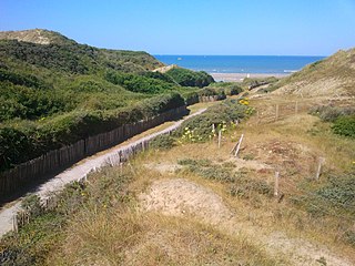
The Boulonnais is the associated coast and hinterland of Boulogne-sur-Mer in Northern France. It includes the catchment of the town's river Liane, and other shorter small rivers that also flow west. It spans north to all of Cap Gris-Nez which has two coasts but not the bay of Wissant. It runs south 30 kilometres almost to Camiers, a village north of Le Touquet, a nonetheless low-rise, but estuarine conglomeration of housing and holiday parks, as the Boulonnais includes Dannes and its golf courses. It extends between 15 to 20 kilometres inland. It has a curved belt of chalk downs which meet the sea at both ends, the higher being Gris-Nez. It is a well-wooded zone almost entirely within the Caps et Marais d'Opale Regional Natural Park and is the east end of the Weald-Artois Anticline. Its coast all faces west to the English Channel, apart from a short north coast, including the small beach of Cap Gris-Nez which faces the Strait of Dover. It is the northernmost west-facing coast of France.

<span class="mw-page-title-main">Aix-Noulette</span> Commune in Hauts-de-France, France

Aix-Noulette is a commune in the Pas-de-Calais department in the Hauts-de-France region of France about 5 miles (8.0 km) west of Lens.

<span class="mw-page-title-main">Hinges, Pas-de-Calais</span> Commune in Hauts-de-France, France

Hinges is a commune in the Pas-de-Calais department in the Hauts-de-France region of France about 3 miles (4.8 km) north of Béthune. The Canal d’Aire flows around the north-eastern part of the commune.

<span class="mw-page-title-main">Fleurbaix</span> Commune in Hauts-de-France, France

Fleurbaix is a commune in the Pas-de-Calais department in the Hauts-de-France region of France about 15 miles (24 km) northeast of Béthune and 13 miles (21 km) west of Lille, at the border with the department of Nord. A stream, the Becque du Biez, flows through the commune.

<span class="mw-page-title-main">Mazingarbe</span> Commune in Hauts-de-France, France

Mazingarbe is a commune in the Pas-de-Calais department in the Hauts-de-France region of France 3 miles (4.8 km) northwest of Lens.

<span class="mw-page-title-main">Puisieux, Pas-de-Calais</span> Commune in Hauts-de-France, France

Puisieux or Puisieux-au-Mont is a commune in the Pas-de-Calais department in the Hauts-de-France region of France.

<span class="mw-page-title-main">Rivière, Pas-de-Calais</span> Commune in Hauts-de-France, France

Rivière is a commune in the Pas-de-Calais department in the Hauts-de-France region of France 6 miles (10 km) southwest of Arras.

<span class="mw-page-title-main">Sailly-sur-la-Lys</span> Commune in Hauts-de-France, France

Sailly-sur-la-Lys is a commune in the Pas-de-Calais department in the Hauts-de-France region of France.

<span class="mw-page-title-main">Saint-Martin-Boulogne</span> Commune in Hauts-de-France, France

Saint-Martin-Boulogne is a commune in the Pas-de-Calais department in the Hauts-de-France region of France.

<span class="mw-page-title-main">Wissant</span> Commune in Hauts-de-France, France

Wissant is a seaside commune in the Pas-de-Calais department in the Hauts-de-France region of France approximately 18 kilometres (11 mi) north of Boulogne, 16 kilometres (9.9 mi) west-southwest of Calais on the English Channel coast.

<span class="mw-page-title-main">Wimille</span> Commune in Hauts-de-France, France

Wimille is a commune in the Pas-de-Calais department in the Hauts-de-France region of France about 3 miles (4.8 km) north of Boulogne, on the banks of the river Wimereux. The river Slack forms the northern boundary of the commune.

References

  1. "Répertoire national des élus: les maires". data.gouv.fr, Plateforme ouverte des données publiques françaises (in French). 9 August 2021.
  2. "Populations légales 2021" (in French). The National Institute of Statistics and Economic Studies. 28 December 2023.
  3. INSEE commune file
  4. "Guglielmo Marconi". National Trust. Retrieved 15 March 2016.
  5. "Lady Hadfield, Obituary". The Times. 8 November 1949.
  6. GEDDES, JENNIAN F (1 January 2007). "Deeds and Words in the Suffrage Military Hospital in Endell Street". Medical History. 51 (1): 79–98. doi:10.1017/s0025727300000909. ISSN   0025-7273. PMC   1712367 . PMID   17200698.
  7. Rankin, Nicholas (2008). Churchill's Wizards - the British genius for deception, 1914 - 1945. London: Faber and Faber. p. 86. ISBN   978-0-571-22195-0.
  8. The CWGC cemetery
  9. Population en historique depuis 1968, INSEE