Derrylough, County Down

Last updated

Derrylough
County
Country Northern Ireland
Sovereign state United Kingdom
Postcode district BT32
Dialling code 028
EU Parliament Northern Ireland
List of places
UK
Northern Ireland
Down

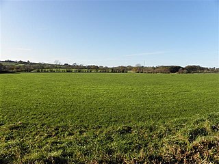
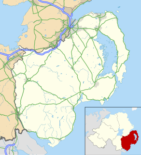
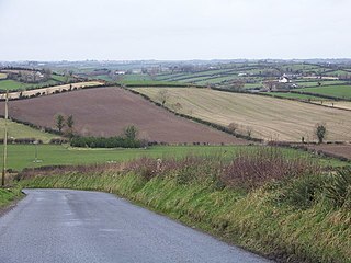
Derrylough (from Irish : Doire Locha, meaning "oak-wood of the lake") is a townland of 222 acres in County Down, Northern Ireland. [1] It is situated in the civil parish of Annaclone and the historic barony of Iveagh Upper, Upper Half. [2] It is the most northerly townland in the parish of Annaclone. [1]

Irish language Gaelic language spoken in Ireland and by Irish people

Irish is a Goidelic language of the Celtic languages family, itself a branch of the Indo-European language family. Irish originated in Ireland and was historically spoken by Irish people throughout Ireland. Irish is spoken as a first language in substantial areas of counties Galway, Kerry, Cork and Donegal, smaller areas of Waterford, Mayo and Meath, and a few other locations, and as a second language by a larger group of habitual but non-traditional speakers across the country.

A townland is a small geographical division of land used in Ireland and in the Western Isles in Scotland. The townland system is of Gaelic origin, pre-dating the Norman invasion, and most have names of Irish Gaelic origin. However, some townland names and boundaries come from Norman manors, plantation divisions, or later creations of the Ordnance Survey. The total number of inhabited townlands in Ireland was 60,679 in 1911. The total number recognised by the Irish Place Names database as of 2014 was 61,098, including uninhabited townlands, mainly small islands.

County Down Place in Northern Ireland, United Kingdom

County Down is one of six counties that form Northern Ireland, in the northeast of the island of Ireland. It covers an area of 2,448 km2 and has a population of 531,665. It is also one of the thirty-two traditional counties of Ireland and is within the province of Ulster. It borders County Antrim to the north, the Irish Sea to the east, County Armagh to the west, and County Louth across Carlingford Lough to the southwest.

Related Research Articles

Dunamuggy human settlement in United Kingdom

Dunamuggy is a townland of 172 acres in County Antrim, Northern Ireland. It is situated in the civil parish of Donegore and the historic barony of Antrim Upper.

Drumbeg, County Down village in County Down, Northern Ireland

Drumbeg is a small village, townland and civil parish on the south bank of the River Lagan in County Down, Northern Ireland. The village is covered by the Lisburn City Council area and forms part of the suburban fringe of Belfast.

Lower Ballinderry village in the United Kingdom

Lower Ballinderry is a small village to the west of Upper Ballinderry in County Antrim, Northern Ireland. It is within the townland and civil parish of Ballinderry and the historic barony of Massereene Upper. The village lies a short distance to the southeast of Portmore Lough and Lough Neagh, 12 km to the west of Lisburn. In the 2001 Census it had a population of 441 people.

Aughnacloy is a townland of 115 acres in County Tyrone, Northern Ireland. It is situated in the civil parish of Annaclone and the historic barony of Iveagh Upper, Upper Half.

Derryneill human settlement in United Kingdom

Derryneill is a townland of 1,049 acres in County Down, Northern Ireland, near to Leitrim, County Down. It is situated in the civil parish of Drumgooland and the historic barony of Iveagh Upper, Lower Half. Derryneill is mainly made up of small rocky drumlins.

Annaclone village in United Kingdom

Annaclone is a village and civil parish between Rathfriland and Banbridge in south County Down, Northern Ireland, about 7 km south-east of Banbridge. The village is situated in the townlands of Ardbrin and Tullintanvally and both it and the civil parish are located in the historic barony of Iveagh Upper, Upper Half. It had a population of 150 people in the 2011 Census.

Solar, County Antrim

Solar is a townland of 42 acres in County Antrim, Northern Ireland. It is situated in the civil parish of Carncastle and the historic barony of Glenarm Upper.

Iveagh Upper, Upper Half Place in Northern Ireland, United Kingdom

Iveagh Upper, Upper Half is the name of a barony in County Down, Northern Ireland. It was created by 1851 with the division of the barony of Iveagh Upper into two. It lies to the west and south of the county, split in half by the Lordship of Newry. It is bordered by six other baronies: Mourne to the south; Iveagh Upper, Lower Half to the east; Iveagh Lower, Lower Half and Iveagh Lower, Upper Half to the north; and Orior Lower and Orior Upper to the west.

Ballynafern is a townland of 778 acres in County Down, Northern Ireland. It is situated in the civil parish of Annaclone and the historic barony of Iveagh Upper, Upper Half.

Ballynafoy may refer to:

Ballynafoy (Annaclone)

Ballynafoy (Annaclone) is a townland of 901 acres in County Down, Northern Ireland. It is situated in the civil parish of Annaclone and the historic barony of Iveagh Upper, Upper Half.

Ballynagross is a townland of 368 acres in County Down, Northern Ireland. It is situated in the civil parish of Annaclone and the historic barony of Iveagh Upper, Upper Half.

Lisnasliggan human settlement in United Kingdom

Lisnasliggan is a townland of 568 acres in County Down, Northern Ireland. It is situated in the civil parish of Annaclone and the historic barony of Iveagh Upper, Upper Half.

Derrylough may refer to:

Ballynanny may refer to:

Ballynanny (Annaclone) is a townland of 538 acres in County Down, Northern Ireland. It is situated in the civil parish of Annaclone and the historic barony of Iveagh Upper, Upper Half.

Ballysheil is a townland of 385 acres in County Down, Northern Ireland. It is situated in the civil parish of Annaclone and the historic barony of Iveagh Upper, Upper Half.

Ardbrin is a townland of 1,007 acres in County Down, Northern Ireland. It is situated in the civil parish of Annaclone and the historic barony of Iveagh Upper, Upper Half.

Derriaghy

Derriaghy,, , is a townland and civil parish in County Antrim, Northern Ireland, 5.5 miles (9 km) south-west of Belfast city centre. The townland is situated in the historic barony of Belfast Upper and the civil parish covers areas of both Belfast Upper and the barony of Massereene Upper.

References

  1. 1 2 "Derrylough". Place Names NI. Retrieved 18 April 2015.
  2. "Derrylough". Ire Atlas Townlands Database. Retrieved 18 April 2015.