Dickson City, Pennsylvania

Last updated • 8 min readFrom Wikipedia, The Free Encyclopedia

Dickson City, Pennsylvania
Dickson City PA.JPG
Flag of Dickson City, Pennsylvania.png
Lackawanna County Pennsylvania Incorporated and Unincorporated areas Dickson City Highlighted.svg
Location of Dickson City in Lackawanna County, Pennsylvania
USA Pennsylvania location map.svg
Red pog.svg
Dickson City
Location in Pennsylvania
Usa edcp location map.svg
Red pog.svg
Dickson City
Location in the United States
Coordinates: 41°27′58″N75°37′31″W / 41.46611°N 75.62528°W / 41.46611; -75.62528
CountryUnited States
StatePennsylvania
County Lackawanna
Foundedunknown date, probably c.1863?
Government
  MayorRobert W. MacCallum (D)
Area
[1]
  Total
4.79 sq mi (12.42 km2)
  Land4.79 sq mi (12.42 km2)
  Water0.00 sq mi (0.00 km2)
Elevation
827 ft (252 m)
Population
 (2020) [2]
  Total
6,038
  Density1,259.23/sq mi (486.15/km2)
Time zone UTC-5 (EST)
  Summer (DST) UTC-4 (EDT)
Zip Code
18508, 18519, 18447 (Miles Plot area, shared with Olyphant)
Area code 570/272
FIPS code 42-19160
Website dicksoncityborough.org

Dickson City is a borough in Lackawanna County, Pennsylvania, United States, 4 miles (6 km) north of Scranton. Coal mining was an important industry in the past. The borough's population peaked at 12,395 in 1930 and was 6,051 at the 2020 census. [3]

Contents

History

Dickson City was once known as Priceburg. It was the newest village in the valley and one of the most progressive. German immigrants then founded the village of Priceville in 1863, in honor of Eli Price. This section of the town developed rapidly after 1880, when John Jermyn sank the shaft which is now known as the Johnson shaft. Here the population had grown from 329 to 841.

In June 1875, Dickson City was incorporated as a borough, including at the time all of the present borough of Throop. Dickson City received its name from Thomas Dickson, founder of the Dickson Manufacturing Company. [4]

Once dominated by coal mines, this borough has in recent times become the center of a thriving retail corridor focused along Business Route 6 and around the Viewmont Mall. Many of the nation's big-box stores and chain restaurants are represented here.

Most of the newer retail complexes are located along Viewmont Drive and Commerce Boulevard, both built by developers to access the borough's vast dormant coal lands. Some of the centers that were built in the 1990s and early 2000s include Dickson City Crossings, Dickson City Commons, Park Center and Commerce Plaza.

After Route 6 (also named the Scranton/Carbondale Highway), Main Street serves as the borough's other major thoroughfare. It features a slightly older stock of stores, bars, professional offices and homes.

One point of major contention in the borough has been a 240-acre (0.97 km2) swath of reclaimed coal-mining land south of Commerce Boulevard that was deeded to the borough for public use after the state government cleaned it up. Plans to build a bond-financed municipal golf course on the land launched during the early 2000s were scuttled after some borough council members campaigned against that form of borrowing and won the majority of seats. The land was seized by a local bank after interim loans went unpaid, but because the state stipulated that it has to remain in the hands of a municipality, neighboring borough Dunmore snapped it up.

Geography

Dickson City is located at 41°27′58″N75°37′31″W / 41.46611°N 75.62528°W / 41.46611; -75.62528 (41.465984, -75.625401). [5] According to the United States Census Bureau, the borough has a total area of 4.8 square miles (12 km2), all land.

Interstate 81 has two commercially-important exits in Dickson City—one with Main Avenue and one with the old 6 (the Scranton-Carbondale Highway.) The Viewmont Mall is in both Dickson City and Scranton. The geographic location of the center of business dictates the revenue, according to Pennsylvania tax law.

Demographics

Historical population
CensusPop.Note
1870 391
1880 838114.3%
1890 3,110271.1%
1900 4,94859.1%
1910 9,33188.6%
1920 11,04918.4%
1930 12,39512.2%
1940 11,548−6.8%
1950 8,948−22.5%
1960 7,738−13.5%
1970 7,698−0.5%
1980 6,699−13.0%
1990 6,276−6.3%
2000 6,205−1.1%
2010 6,070−2.2%
2020 6,051−0.3%
2021 (est.)6,033 [3] −0.3%
Sources: [6] [7] [8] [9] [2]

2010

As of the census [10] of 2010, there were 6,070 people, 2,703 households, and 1,636 families living in the borough. The population density was 1,264.6 inhabitants per square mile (488.3/km2). There were 2,921 housing units at an average density of 608.5 units per square mile (234.9 units/km2). The racial makeup of the borough was 95.9% White, 1% African American, 0.1% Native American, 0.7% Asian, 1.1% from other races, and 1.3% from two or more races. Hispanic or Latino of any race were 3.8% of the population.

There were 2,703 households, out of which 22.7% had children under the age of 18 living with them, 43.4% were married couples living together, 12.4% had a female householder with no husband present, and 39.5% were non-families. 33.9% of all households were made up of individuals, and 14.8% had someone living alone who was 65 years of age or older. The average household size was 2.24 and the average family size was 2.86.

In the borough the population was spread out, with 18.9% under the age of 18, 62% from 18 to 64, and 19.1% who were 65 years of age or older. The median age was 42.3 years.

The median income for a household in the borough was $31,422, and the median income for a family was $41,394. Males had a median income of $32,174 versus $23,766 for females. The per capita income for the borough was $17,370. About 3.5% of families and 6.9% of the population were below the poverty line, including 6.6% of those under age 18 and 8.7% of those age 65 or over.

2000

As of the census [7] of 2000, there were 6,205 people, 2,692 households, and 1,722 families living in the borough. The population density was 1,317.4 inhabitants per square mile (508.7/km2). There were 2,913 housing units at an average density of 618.5 units per square mile (238.8 units/km2). The racial makeup of the borough was 98.82% White, 0.24% African American, 0.06% Native American, 0.26% Asian, 0.21% from other races, and 0.40% from two or more races. Hispanic or Latino of any race were 0.84% of the population.

There were 2,692 households, out of which 25.1% had children under the age of 18 living with them, 48.6% were married couples living together, 11.5% had a female householder with no husband present, and 36.0% were non-families. 31.6% of all households were made up of individuals, and 17.3% had someone living alone who was 65 years of age or older. The average household size was 2.30 and the average family size was 2.91.

In the borough the population was spread out, with 19.9% under the age of 18, 7.1% from 18 to 24, 28.6% from 25 to 44, 22.8% from 45 to 64, and 21.6% who were 65 years of age or older. The median age was 41 years. For every 100 females there were 88.4 males. For every 100 females age 18 and over, there were 85.6 males.

The median income for a household in the borough was $31,422, and the median income for a family was $41,394. Males had a median income of $32,174 versus $23,766 for females. The per capita income for the borough was $17,370. About 3.5% of families and 6.9% of the population were below the poverty line, including 6.6% of those under age 18 and 8.7% of those age 65 or over.

Education

It is in the Mid Valley School District. [11]

While the anthracite coal industry was thriving, there were numerous neighborhood schools: the Columbus School on Main Street between Bowman Street and Shaeffer Street, the Jefferson School on Bell Mountain where Center Street meets Laybourne Street, the Lafayette School on Main Street near Pancost Street, the Lincoln School at the corner of Lincoln Street and Grier Street, and the Wilson School at the corner of Boulevard Avenue and Bridge Street. Dickson City Junior High School was on a block on the block between Jackson Street and Jermyn Street and faced Albert Street; Dickson City Senior High School was next door and faced Carmalt Street.

As the population declined, the neighborhood schools were closed, and the junior high school became a kindergarten through 8th grade school. In 1969, the Olyphant, Dickson City, and Throop school districts consolidated to form the Mid Valley School District. Dickson City Junior High School became Mid-Valley Junior High School; Dickson City Senior High School became Dickson City Elementary School. Currently, the Mid-Valley School District has a single elementary school, and a single secondary school on Underwood Road in Throop. [12]

Johnson Technical Institute is located just over the border in the nearby city, Scranton.

Dickson City is the location of one of the family service centers for Commonwealth Charter Academy, an online K-12 free public virtual charter school.

Public safety

Police department

Dickson City Borough is currently served by a full-time police department consisting of both full-time and part-time police officers. The Dickson City Police headquarters is at 901 Enterprise Street. When requested the Lackawanna County Sheriff's Office, Lackawanna County SWAT, the Pennsylvania State Police (Dunmore Barracks), and neighboring municipal jurisdictions will assist borough police officers if additional law enforcement resources are needed. [13]

Fire department

Eagle Hose Company No.1 provides fire and rescue services to the borough. Eagle Hose Company No. 1 (Dickson City Fire Department) operates 1 fire station (located at 1 Eagle Lane) which houses one ladder company, one engine company, one rescue company, and two support vehicles: an incident command SUV and utility pickup truck. [14] The department is the only fire company in Dickson City Borough and is staffed by 100% volunteer firefighters. The fire company currently has 60 active members under the direction of Fire Chief Matthew Horvath. [15] Eagle Hose Company No. 1 also has mutual aid agreements with neighboring fire departments to provide assistance to their coverage areas when requested. Mutual aid agreements are also in place to have other fire departments provide assistance to Dickson City Borough when requested, as well as give aid to surrounding boroughs. The Eagle Hose Company No. 1 is currently an ISO Class 3 Department. The Eagle Hose Company No. 1 is also recognized as a Participating Department within the Commonwealth of Pennsylvania through the Pennsylvania State Fire Commissioner's Office. [15]

Emergency medical services

Pennsylvania Ambulance primarily renders emergency medical services (EMS) to borough residents and visitors. Pennsylvania Ambulance is a paid service that currently offers both basic life support (BLS) and advanced life support (ALS) services with 25 ambulances, seven quick response vehicles, one physician response vehicle, one ATV for off-road rescue, one special operations/rehab vehicle, ten wheelchair vans and one ten-passenger bus. [16] While Pennsylvania Ambulances's main EMS station is located in Scranton, the organization sends its ambulances to strategic locations to best provide ambulance coverage throughout Lackawanna County. Commonwealth Health Emergency Medical Services and Cottage Hose Company Ambulance Corps will also provide ambulance coverage if they are the closest available service. Emergency services were previously provided by the Dickson City Community Ambulance Association, which was disbanded in 2020. [17]

9-1-1 service

The Lackawanna County Department of Emergency Services operates the 9-1-1 center responsible for all incoming calls and incidents occurring in Lackawanna County, including Dickson City Borough. It is also responsible for the dispatch and radio communication of all police, fire, and EMS services in Lackawanna County. [18]

Related Research Articles

<span class="mw-page-title-main">Wayne County, Pennsylvania</span> County in Pennsylvania

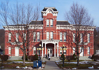
Wayne County is a county in the Commonwealth of Pennsylvania. The county's population was 51,155 at the 2020 census. The county seat is the Borough of Honesdale. The county was formed from part of Northampton County on March 21, 1798, and was named for the Revolutionary War General Anthony Wayne. The county is part of the Northeast Pennsylvania and Pocono Mountains region of the state.

<span class="mw-page-title-main">Lackawanna County, Pennsylvania</span> County in Pennsylvania, United States

Lackawanna County is a county in the Commonwealth of Pennsylvania. It is located in Northeastern Pennsylvania and had a population of 215,615 (2022). Its county seat and most populous city is Scranton.

<span class="mw-page-title-main">Waverly Township, Pennsylvania</span> Township in Pennsylvania, United States

Waverly Township is a township in Lackawanna County, Pennsylvania, United States. It is bordered by Dalton and Glenburn townships to the west, North Abington Township to the north, the boroughs of Clarks Summit and Clarks Green to the south, and South Abington Township to the south and southeast. Waverly Township is part of a suburban area known as "the Abingtons". The population was 1,861 at the 2020 census.

<span class="mw-page-title-main">Carbondale, Pennsylvania</span> City in Pennsylvania, United States

Carbondale is a city in Lackawanna County, Pennsylvania, United States. Carbondale is located approximately 15 miles due northeast of the city of Scranton in Northeastern Pennsylvania. The population was 8,828 at the 2020 census.

<span class="mw-page-title-main">Clarks Summit, Pennsylvania</span> Borough in Pennsylvania, United States

Clarks Summit is a borough in Lackawanna County, northwest of Scranton in Northeastern Pennsylvania. The population was 5,108 at the 2020 census. It is also the northern control city of the Pennsylvania Turnpike Northeast Extension, I-476, though the official terminus is in adjacent South Abington Township.

<span class="mw-page-title-main">Dalton, Pennsylvania</span> Borough in Pennsylvania, United States

Dalton is a borough in Lackawanna County, Pennsylvania, United States. It is part of Northeastern Pennsylvania and is located approximately eight miles north of the city of Scranton in a suburban area known as "the Abingtons." Dalton is also approximately three miles north of Clarks Summit, the hub of the Abington community. The population was 1,283 at the 2020 census.

<span class="mw-page-title-main">Dunmore, Pennsylvania</span> Borough in Pennsylvania, United States

Dunmore is a borough in Lackawanna County, Pennsylvania, United States, adjoining Scranton. It is part of Northeastern Pennsylvania and was settled in 1835 and incorporated in 1862. Extensive anthracite coal, brick, stone, and silk interests had led to a rapid increase in the population from 8,315 in 1890 to 23,086 in 1940. The population was 14,042 in the 2020 census.

<span class="mw-page-title-main">Jermyn, Pennsylvania</span> Borough in Pennsylvania, United States

Jermyn, known as "The Birthplace of First Aid in America", is a borough which is located in Lackawanna County, Pennsylvania, United States. Located on the Lackawanna River, it is 12 miles (19 km) northeast of Scranton.

<span class="mw-page-title-main">Mayfield, Pennsylvania</span> Borough in Pennsylvania, United States

Mayfield is a borough in Lackawanna County, Pennsylvania, United States, approximately 14 miles (23 km) northeast of Scranton. In the past, it contained a silk mill and a coal mining industry. The population was 1,763 at the 2020 census.

<span class="mw-page-title-main">Moosic, Pennsylvania</span> Borough in Pennsylvania, United States

Moosic is a borough in Lackawanna County, Pennsylvania, United States, 3 miles (5 km) south of downtown Scranton and 10 miles (16 km) northeast of downtown Wilkes-Barre, on the Lackawanna River.

<span class="mw-page-title-main">Moscow, Pennsylvania</span> Borough in Pennsylvania, United States

Moscow is a borough in Lackawanna County, Pennsylvania, United States. The population was 2,039 at the 2020 census. It is located 11 miles (18 km) southeast of Scranton and 24 miles (39 km) southwest of Honesdale.

<span class="mw-page-title-main">Olyphant, Pennsylvania</span> Borough in Pennsylvania, United States

Olyphant is a borough in Lackawanna County, Pennsylvania, United States. It is six miles (10 km) northeast of downtown Scranton, on the Lackawanna River in the heart of the anthracite region of the state. Its main source of employment was the mining and shipping of coal. It was the headquarters of the Lackawanna Coal Company. Other industries of the past were the manufacturing of blasting powder, iron and steel goods, cigars, and silks. Olyphant experienced a severe downturn in the 1950s. There was once a thriving garment industry with numerous dress factories in the downtown area. There was also a slaughterhouse. Until 2018, the biggest industry was Cinram the manufacture of compact discs (CD) and digital video discs (DVD). The population was 5,395 at the 2020 census.

<span class="mw-page-title-main">Scott Township, Lackawanna County, Pennsylvania</span> Township in Pennsylvania

Scott Township is a township in the north central area of Lackawanna County, Pennsylvania, United States. As of the 2020 census, it had a population of 4,641.

<span class="mw-page-title-main">Taylor, Pennsylvania</span> Borough in Pennsylvania, United States

Taylor is a borough in Lackawanna County, Pennsylvania, United States, 3 miles (5 km) southwest of Scranton on the Lackawanna River. It was founded in 1790 by Cornelius Atherton. Silk manufacturing and coal mining were once practiced in the borough. Most of Taylor is built over abandoned mines. The Pennsylvania Turnpike Northeast Extension (I-476), accessible via the Keyser Avenue Interchange, passes through Taylor, going north to Clarks Summit and south to Philadelphia.

<span class="mw-page-title-main">Throop, Pennsylvania</span> Borough in Pennsylvania, United States

Throop is a borough in Lackawanna County, Pennsylvania, United States, adjoining Scranton. Formerly, coal mining and silk manufacturing provided employment for the people of Throop, who numbered 2,204 in 1900 and 5,133 in 1910. In 1940, 7,382 people lived in Throop. The population was 4,078 at the 2020 census.

<span class="mw-page-title-main">Pittston Township, Pennsylvania</span> Township in Pennsylvania, United States

Pittston Township is a township in Luzerne County, Pennsylvania. The population was 3,179 as of the 2020 census. The township is located within the Greater Pittston region. As of 2010, the total population of Greater Pittston was 48,020. The Wilkes-Barre/Scranton International Airport is located in Pittston Township.

<span class="mw-page-title-main">Stockertown, Pennsylvania</span> Place in Pennsylvania, United States

Stockertown is a borough in Northampton County, Pennsylvania. The borough's population was 927 as of the 2010 census. It is part of the Lehigh Valley metropolitan area, which had a population of 861,899 and was the 68th-most populous metropolitan area in the U.S. as of the 2010 census.

<span class="mw-page-title-main">Nicholson, Pennsylvania</span> Borough in Pennsylvania, United States

Nicholson is a borough in Wyoming County, Pennsylvania. The population was 698 at the 2020 census.

<span class="mw-page-title-main">Wrightsville, Pennsylvania</span> Borough in Pennsylvania, United States

Wrightsville is a borough in York County, Pennsylvania, United States. The population was 2,257 at the time of the 2020 census. It is part of the York–Hanover metropolitan area.

<span class="mw-page-title-main">Mid Valley School District</span> School district in Lackawanna County, Pennsylvania, USA

Mid Valley School District is a small, suburban, school district located in Lackawanna County, Pennsylvania, comprising the boroughs of Olyphant, Dickson City, and Throop. Mid Valley School District encompasses approximately 15 square miles (39 km2). According to 2000 federal census data, it serves a resident population of 15,193. By 2010, the district's population increased to 15,304 people. The educational attainment levels for the Mid Valley School District population were 89.9% high school graduates and 20.8% college graduates. The district is one of 12 public school districts in Lackawanna County and one of the 500 public school districts of Pennsylvania.

References

  1. "ArcGIS REST Services Directory". United States Census Bureau. Retrieved October 12, 2022.
  2. 1 2 "Census Population API". United States Census Bureau. Retrieved October 12, 2022.
  3. 1 2 "City and Town Population Totals: 2020—2021". Census.gov. US Census Bureau. Retrieved August 5, 2022.
  4. http://dicksoncityborough.org/documents/history.pdf [ bare URL PDF ]
  5. "US Gazetteer files: 2010, 2000, and 1990". United States Census Bureau. February 12, 2011. Retrieved April 23, 2011.
  6. "Census of Population and Housing". U.S. Census Bureau. Retrieved December 11, 2013.
  7. 1 2 "U.S. Census website". United States Census Bureau . Retrieved January 31, 2008.
  8. "Incorporated Places and Minor Civil Divisions Datasets: Subcounty Resident Population Estimates: April 1, 2010 to July 1, 2012". Population Estimates. U.S. Census Bureau. Archived from the original on June 11, 2013. Retrieved December 11, 2013.
  9. "Census of Population and Housing". Census.gov. Retrieved June 4, 2016.
  10. "U.S. Census website". United States Census Bureau . Retrieved May 14, 2011.
  11. "2020 CENSUS - SCHOOL DISTRICT REFERENCE MAP: Lackawanna County, PA" (PDF). U.S. Census Bureau. Archived (PDF) from the original on October 9, 2022. Retrieved November 1, 2024. - Text list
  12. Klapatch, Joseph (May 2015). The old school : the Mid-Valley Elementary School in Olyphant, Pennsylvania (First ed.). Galloway, NJ: Joseph Peter Klapatch. ISBN   9781633187276.
  13. "Dickson City Borough". dicksoncityborough.org. Retrieved March 20, 2020.
  14. "Apparatus". www.dcfd23.com. Retrieved March 20, 2020.
  15. 1 2 "About Us". www.dcfd23.com. Retrieved March 20, 2020.
  16. "About Us". Pennsylvania Ambulance. Retrieved March 20, 2020.
  17. Dickson City Borough Council minutes, 8-11-2020.
  18. "Emergency Services / 9-1-1 « Lackawanna County" . Retrieved March 20, 2020.