Doland, South Dakota | |
---|---|
Motto: Home of Heroes | |
Coordinates: 44°53′40″N98°05′59″W / 44.89444°N 98.09972°W | |
Country | United States |
State | South Dakota |
County | Spink |
Incorporated | 1909 [1] |
Government | |
• Mayor | Stuart Bell [ citation needed ] |
Area | |
• Total | 0.59 sq mi (1.52 km2) |
• Land | 0.59 sq mi (1.52 km2) |
• Water | 0.00 sq mi (0.00 km2) |
Elevation | 1,355 ft (413 m) |
Population | |
• Total | 199 |
• Density | 338.44/sq mi (130.57/km2) |
Time zone | UTC-6 (Central (CST)) |
• Summer (DST) | UTC-5 (CDT) |
ZIP code | 57436 |
Area code | 605 |
FIPS code | 46-16820 [5] |
GNIS feature ID | 1267355 [3] |
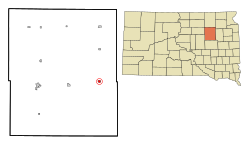
Doland is a city in eastern Spink County, South Dakota, United States. The population was 199 at the 2020 census. [6]
Doland was platted in 1882. [7] The city was named for Civil War veteran Franklin Henry Doland, an original owner of the town site. [7] [8] Doland purchased several hundred acres in the expected path of the Chicago and North Western railroad which was moving westward into South Dakota. The railroad created a depot for shipping for farmers at the location. [9] A post office has been in operation in Doland since 1882. [10]
According to the United States Census Bureau, the city has a total area of 0.59 square miles (1.53 km2), all land. [11]
Census | Pop. | Note | %± |
---|---|---|---|
1890 | 216 | — | |
1900 | 235 | 8.8% | |
1910 | 581 | 147.2% | |
1920 | 667 | 14.8% | |
1930 | 538 | −19.3% | |
1940 | 542 | 0.7% | |
1950 | 535 | −1.3% | |
1960 | 481 | −10.1% | |
1970 | 430 | −10.6% | |
1980 | 381 | −11.4% | |
1990 | 306 | −19.7% | |
2000 | 297 | −2.9% | |
2010 | 180 | −39.4% | |
2020 | 199 | 10.6% | |
U.S. Decennial Census [12] [4] |
As of the census [13] of 2010, there were 180 people, 95 households, and 47 families residing in the city. The population density was 305.1 inhabitants per square mile (117.8/km2). There were 131 housing units at an average density of 222.0 per square mile (85.7/km2). The racial makeup of the city was 98.9% White, 0.6% Native American, and 0.6% from two or more races. Hispanic or Latino of any race were 1.7% of the population.
There were 95 households, of which 14.7% had children under the age of 18 living with them, 40.0% were married couples living together, 5.3% had a female householder with no husband present, 4.2% had a male householder with no wife present, and 50.5% were non-families. 46.3% of all households were made up of individuals, and 17.9% had someone living alone who was 65 years of age or older. The average household size was 1.89 and the average family size was 2.68.
The median age in the city was 50.2 years. 15.6% of residents were under the age of 18; 7.7% were between the ages of 18 and 24; 15% were from 25 to 44; 42.8% were from 45 to 64; and 18.9% were 65 years of age or older. The gender makeup of the city was 47.2% male and 52.8% female.
As of the census [5] of 2000, there were 297 people, 120 households, and 75 families residing in the city. The population density was 504.0 inhabitants per square mile (194.6/km2). There were 159 housing units at an average density of 269.8 per square mile (104.2/km2). The racial makeup of the city was 96.97% White, 0.67% African American, 1.35% Native American, 0.34% from other races, and 0.67% from two or more races. Hispanic or Latino of any race were 0.67% of the population.
There were 120 households, out of which 33.3% had children under the age of 18 living with them, 55.0% were married couples living together, 5.0% had a female householder with no husband present, and 36.7% were non-families. 34.2% of all households were made up of individuals, and 19.2% had someone living alone who was 65 years of age or older. The average household size was 2.48 and the average family size was 3.22.
In the city, the population was spread out, with 30.3% under the age of 18, 5.7% from 18 to 24, 29.0% from 25 to 44, 20.2% from 45 to 64, and 14.8% who were 65 years of age or older. The median age was 37 years. For every 100 females, there were 95.4 males. For every 100 females age 18 and over, there were 97.1 males.
The median income for a household in the city was $30,313, and the median income for a family was $35,625. Males had a median income of $24,375 versus $20,357 for females. The per capita income for the city was $17,437. About 20.3% of families and 19.9% of the population were below the poverty line, including 28.4% of those under the age of eighteen and 14.3% of those 65 or over.
The Doland Public School system includes Doland Elementary School PK-6; Hillside Colony School K-8; Doland Junior High School (about 20 students) 7-8; and Doland High School (about 50 students).
Dakota is a city in Winona County, Minnesota, United States. The population was 295 at the 2020 census.
Niagara is a city in Grand Forks County, North Dakota, United States. It is part of the "Grand Forks, ND-MN Metropolitan Statistical Area" or "Greater Grand Forks". The population was 46 at the 2020 census. Niagara was founded in 1883.
Ruso is a hamlet in McLean County, North Dakota, United States. The population was 1 at the 2020 census, making Ruso the least populous incorporated place in North Dakota.
Yale is an incorporated town in Beadle County, South Dakota, United States. The population was 112 at the 2020 census.
Hecla is a city in Brown County, South Dakota, United States, located only a few miles south of the North Dakota border. The population was 193 at the 2020 census. State Highway 37 runs along the east side of town.
Verdon is a town in southeastern Brown County, South Dakota, United States. The population was 3 at the 2020 census.
Lake Andes is a city in, and the county seat of, Charles Mix County, South Dakota, United States. The population was 710 at the 2020 census.
Wallace is a town in Codington County, South Dakota, United States. The population was 91 at the 2020 census. It is part of the Watertown, South Dakota Micropolitan Statistical Area.
Clear Lake is a city in and the county seat of Deuel County, South Dakota, United States. The population was 1,218 at the 2020 census.
Faulkton is a city in and county seat of Faulk County, South Dakota, United States. The population was 826 at the 2020 census. The city's nickname is "The Carousel City".
Milbank is a city in Grant County, South Dakota, United States, located along the South Fork of the Whetstone River. The population was 3,544 at the 2020 census. It is the county seat of Grant County. Milbank is the birthplace of American Legion Baseball. The program was created in Milbank in 1925 and is now enjoyed by high school aged youth on more than five thousand teams in all fifty states.
Burke is a city in and county seat of Gregory County, South Dakota, United States. The population was 575 at the 2020 census.
Alexandria is a city in central Hanson County, South Dakota, United States. The population was 649 at the 2020 census. It is the county seat of Hanson County.
Leola is a small city in, and the county seat of, McPherson County, South Dakota, United States. It was founded on May 1, 1884, and named for Leola Haynes, daughter of one of the town's founders. The population was 434 as of the 2020 census.
Crooks is a city in Minnehaha County, South Dakota, United States and is a suburb of Sioux Falls. The population was 1,362 at the 2020 census. Crooks was named New Hope until 1904. The town's present name honors W. A. Crooks, a local politician.
Sherman is a town in Minnehaha County, South Dakota, United States. The population was 81 at the 2020 census.
Claire City is a town in Roberts County, South Dakota, United States. The population was 82 at the 2020 census.
Frankfort is a city in Spink County, South Dakota, United States. The population was 134 at the 2020 census.
Colome is a city in Tripp County, South Dakota, United States. The population was 331 as of the 2020 census.
Alcester is a city in northern Union County, South Dakota, United States. It is part of the Sioux City, IA–NE–SD Metropolitan Statistical Area. The population was 820 at the 2020 census.
{{cite web}}
: CS1 maint: bot: original URL status unknown (link)Media related to Doland, South Dakota at Wikimedia Commons