The City of New York, usually called either New York City (NYC) or simply New York (NY), is the most populous city in the United States and the U.S. state of New York. With an estimated 2017 population of 8,622,698 distributed over a land area of about 302.6 square miles (784 km2), New York is also the most densely populated major city in the United States. Located at the southern tip of the state of New York, the city is the center of the New York metropolitan area, the largest metropolitan area in the world by urban landmass and one of the world's most populous megacities, with an estimated 20,320,876 people in its 2017 Metropolitan Statistical Area and 23,876,155 residents in its Combined Statistical Area. A global power city, New York City has been described as the cultural, financial, and media capital of the world, and exerts a significant impact upon commerce, entertainment, research, technology, education, politics, tourism, art, fashion, and sports. The city's fast pace has inspired the term New York minute. Home to the headquarters of the United Nations, New York is an important center for international diplomacy.
Queens is the easternmost of the five boroughs of New York City. It is the largest borough geographically and is adjacent to the borough of Brooklyn at the southwestern end of Long Island. To its east is Nassau County. Queens also shares water borders with the boroughs of Manhattan and the Bronx. Coterminous with Queens County since 1899, the borough of Queens is the second largest in population, with an estimated 2,358,582 residents in 2017, approximately 48% of them foreign-born. Queens County also is the second most populous county in the U.S. state of New York, behind Brooklyn, which is coterminous with Kings County. Queens is the fourth most densely populated county among New York City's boroughs, as well as in the United States. If each of New York City's boroughs were an independent city, Queens would be the nation's fourth most populous, after Los Angeles, Chicago, and Brooklyn. Queens is the most ethnically diverse urban area in the world.
Douglaston Historic District is a national historic district in Douglaston, Queens, New York. It includes 631 contributing buildings and three contributing sites on a mile-long peninsula extending into Little Neck Bay. All but one of the buildings are in residential use and the majority were built in the early- to mid-20th century as a planned suburban community known as Douglas Manor. In the early 20th century, the Rickert-Finlay Realty Company of Manhattan purchased 175 acres (0.71 km2) of the Douglas' family holdings, and formed the Douglas Manor Association, creating a planned community. Many of the houses in this area were built in architectural styles popular at the time, such as Tudor, Mediterranean, Colonial Revival, and Arts and Crafts. Located within the district are the separately listed Cornelius Van Wyck House and Allen-Beville House. Another notable early building is the Van Zandt manor house, which is now the Douglaston Club.
The North Shore of Long Island is the area along the northern coast of New York's Long Island bordering Long Island Sound. Known for its extreme wealth and lavish estates, the North Shore exploded into affluence at the turn of the 20th century, earning it the nickname the Gold Coast. Historically, this term refers to the coastline communities in the towns of North Hempstead, Oyster Bay, and Huntington, in Nassau and western Suffolk County. The easternmost Gold Coast mansion is the Geissler Estate, located just west of Indian Hills Country Club in Fort Salonga, within the Town of Huntington.
Long Island is a densely populated island off the East Coast of the United States, beginning at New York Harbor approximately 0.35 miles (0.56 km) from Manhattan Island and extending eastward into the Atlantic Ocean. The island comprises four counties in the U.S. state of New York. Kings and Queens Counties and Nassau County share the western third of the island, while Suffolk County occupies the eastern two-thirds. More than half of New York City's residents now live on Long Island, in Brooklyn and Queens. However, many people in the New York metropolitan area colloquially use the term Long Island to refer exclusively to Nassau and Suffolk Counties, which are mainly suburban in character, conversely employing the term the City to mean Manhattan alone.
Douglaston represents one of the least traditionally urban communities in New York City, with many areas (particularly those north of Northern Boulevard) having a distinctly upscale suburban feel, similar to that of Nassau County towns located nearby (such as Great Neck).
Nassau County is a county in the U.S. state of New York. At the 2010 census, the county's population was 1,400,000 estimated to have increased to 1,400,514 in 2017. The county seat is Mineola and the largest town is the Town of Hempstead.
Great Neck is a region on Long Island, New York, that covers a peninsula on the North Shore and includes 9 villages, such as the villages of Great Neck, Great Neck Estates, Great Neck Plaza, and Russell Gardens, and a number of unincorporated areas, as well as an area south of the peninsula near Lake Success and the border territory of Queens. The incorporated village of Great Neck had a population of 9,989 at the 2010 census, while the larger Great Neck area comprises a residential community of some 40,000 people in nine villages and hamlets in the town of North Hempstead, of which Great Neck is the northwestern quadrant. Great Neck has five ZIP Codes (11020–11024), which are united by a park district and one school district.
The area is also known for its historical society and other civic groups, notably the Douglaston Civic Association and the Douglas Manor Association.
History
FDNY Engine 313/Ladder 164 Firehouse on 244th Street
The earliest known residents of the area that would become Douglaston were the MatinecockNative Americans. Early Dutch settlers were drawn to the area by the rich land and abundant fishing. Thomas Hicks settled the area in 1656 on a peninsula first called Little Madnan's Neck. In 1796, his estate passed to Thomas Wickes (1770–1854), and in 1819, to Wyant Van Zandt, a wealthy merchant, who built a large Greek Revival mansion in the area. Today, this mansion houses the Douglaston Club, a private club with tennis courts, social activities and swimming pools. In 1835, George Douglas bought 240 acres (0.97km2) of land along with Van Zandt's mansion. Upon Douglas' death in 1862, the land was inherited by his son, William Douglas. Four years later, the North Shore Railroad extended its service to the area. William Douglas donated an outbuilding for use as the station house, and in thanks, the railroad named its new stop "Douglaston", which soon was taken on as the name of the community.[citation needed]
Native Americans, also known as American Indians, Indigenous Americans and other terms, are the indigenous peoples of the United States, except Hawaii. There are over 500 federally recognized tribes within the US, about half of which are associated with Indian reservations. The term "American Indian" excludes Native Hawaiians and some Alaska Natives, while Native Americans are American Indians, plus Alaska Natives of all ethnicities. Native Hawaiians are not counted as Native Americans by the US Census, instead being included in the Census grouping of "Native Hawaiian and other Pacific Islander".
The Netherlands is a country located mainly in Northwestern Europe. The European portion of the Netherlands consists of twelve separate provinces that border Germany to the east, Belgium to the south, and the North Sea to the northwest, with maritime borders in the North Sea with Belgium, Germany and the United Kingdom. Together with three island territories in the Caribbean Sea—Bonaire, Sint Eustatius and Saba— it forms a constituent country of the Kingdom of the Netherlands. The official language is Dutch, but a secondary official language in the province of Friesland is West Frisian.
Douglaston Hill is the oldest area of the community, and is characterized by turn-of-the-20th-century homes in Queen Anne and Victorian styles. It was laid out with very large lots in 1853, at the very beginning of a movement in the United States to create suburban gardens. The area was recognized as a New York City Historic District in December 2004 by the New York City Landmarks Preservation Commission.[4] The Douglaston Hill Historic District was listed on the National Register of Historic Places in 2000.[5]
Douglaston Hill Historic District is a national historic district in Douglaston, Queens, New York. It includes 83 contributing buildings and two contributing sites. The buildings include Zion Episcopal Church (1830), houses and garages, and commercial buildings. The sites are Zion cemetery and public park. It was laid out with very large lots in 1853, at the very beginning of a movement in the United States to create suburban gardens. The buildings include a number of fine examples of late-19th- and early 20th-century architectural styles such as Queen Anne, Shingle Style, and Colonial Revival. The majority of the buildings date between 1890 and 1940.
Victorian architecture is a series of architectural revival styles in the mid-to-late 19th century. Victorian refers to the reign of Queen Victoria (1837–1901), called the Victorian era, during which period the styles known as Victorian were used in construction. However, many elements of what is typically termed "Victorian" architecture did not become popular until later in Victoria's reign. The styles often included interpretations and eclectic revivals of historic styles. The name represents the British and French custom of naming architectural styles for a reigning monarch. Within this naming and classification scheme, it followed Georgian architecture and later Regency architecture, and was succeeded by Edwardian architecture.
The New York City Landmarks Preservation Commission (LPC) is the New York City agency charged with administering the city's Landmarks Preservation Law. The Commission was created in April 1965 by Mayor Robert F. Wagner, Jr. following the destruction of Pennsylvania Station the previous year to make way for the construction of the current Madison Square Garden. The Commission is responsible for protecting New York City's architecturally, historically, and culturally significant buildings and sites by granting them landmark or historic district status, and regulating them once they're designated. It is the largest municipal preservation agency in the nation.
In the early 20th century, the Rickert-Finlay Realty Company of Manhattan purchased 175 acres (0.71km2) of the Douglas' family holdings, and formed the Douglas Manor Association, creating a planned community. Many of the houses in this area were built in architectural styles popular at the time, such as Tudor, Mediterranean, Colonial Revival, and Arts and Crafts. In 1997, New York City's Landmarks Preservation Commission designated Douglas Manor as the Douglaston Historic District, ensuring that no new buildings or external alterations could be made without the commission's approval.[6][7] The Douglaston Historic District was listed on the National Register of Historic Places in 2005.[5]
Manhattan, often referred to locally as the City, is the most densely populated of the five boroughs of New York City and its economic and administrative center, cultural identifier, and historical birthplace. The borough is coextensive with New York County, one of the original counties of the U.S. state of New York. The borough consists mostly of Manhattan Island, bounded by the Hudson, East, and Harlem rivers; several small adjacent islands; and Marble Hill, a small neighborhood now on the U.S. mainland, physically connected to the Bronx and separated from the rest of Manhattan by the Harlem River. Manhattan Island is divided into three informally bounded components, each aligned with the borough's long axis: Lower, Midtown, and Upper Manhattan.
Colonial Revival architecture was and is a nationalistic design movement in the United States and Canada. Part of a broader Colonial Revival Movement embracing Georgian and Neoclassical styles, it seeks to revive elements of architectural style, garden design, and interior design of American colonial architecture.
The Arts and Crafts movement was an international trend in the decorative and fine arts that began in Britain and flourished in Europe and America between about 1880 and 1920, emerging in Japan in the 1920s as the Mingei movement. It stood for traditional craftsmanship using simple forms, and often used medieval, romantic, or folk styles of decoration. It advocated economic and social reform and was essentially anti-industrial. It had a strong influence on the arts in Europe until it was displaced by Modernism in the 1930s, and its influence continued among craft makers, designers, and town planners long afterwards.
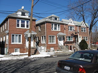
Other areas of Douglaston were developed during the latter half of the 20th century. Douglaston Park contains a mixture of large, older homes as well as Capes, Tudors, and ranch-style homes dating from the 1960s. The areas adjacent to the |Douglaston Shopping Center are occupied mainly by attached single-family homes built in the 1950s through 1970s (Beech Hills, Deepdale and another development known colloquially as the "Korvette's Houses" due to the former proximity of an E.J. Korvette department store), as well as four-story condominiums added in the mid-1980s.[8]
In addition to the Douglaston Historic District and Douglaston Hill Historic District, the Allen-Beville House and Cornelius Van Wyck House are listed on the National Register of Historic Places.[5]
Several parks are under the administration of the New York City Department of Parks and Recreation. To the west of Douglaston along the waterfront is Alley Pond Park, a 635-acre (2.57km2) wildlife and bird sanctuary, and home to the Queens Giant, the oldest known tree (and living thing) in New York City. To the east along the water is Udalls Cove, a 90-acre (360,000m2) wildlife sanctuary.
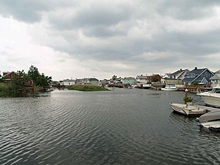
Because northern Douglaston is surrounded by water, many residents take advantage of the waterfront. The Douglaston Yacht Squadron[9] is the local yacht club (there is also a junior yachting program called Douglaston Junior Sailing (DJYS), which teaches youngsters under the age of 16 years how to sail). It is a part of the Douglaston Club, a country club based in Van Zandt's original mansion in Douglas Manor. The Douglaston Club is also site of various community events, such as the Douglaston Chess Congress' annual championships, which decides the community's best players. Sailing is also a popular sport in the community.
Southern Douglaston has an 18-hole, par 67 golf course. Formerly known as the North Hills Country Club, the 104-acre (0.42km2) course opened in 1927 and became a municipal course in the 1960s. The Douglaston Golf Course underwent significant renovations in 2004. The course is situated at one of the highest points in the borough of Queens, providing picturesque views of the Manhattan skyline, and has a restaurant.
The Immaculate Conception Center,[10] formerly a college-level seminary named Cathedral College of the Immaculate Conception and owned by the Roman Catholic Diocese of Brooklyn, is located in southern Douglaston. It is a large conference center, hosting Diocese events and activities including language immersion classes, lay ministry preparation, adult continuing education, seminarian instruction, parish retreats and also hosts community civic conferences. In the Fall of 2011, all administrative offices were relocated and the building hosted eighty undergraduate seminarians studying at nearby St. John's University, in addition to retired priests from the Diocese of Brooklyn.
Its two public elementary schools are P.S. 98 The Douglaston School[11] and P.S. 221 North Hills School,[12] which both offer classes from kindergarten through 5th grade. These schools feed into Louis Pasteur Middle School, which hosts children in grades 6 through 8. After middle school, Douglaston's public school students are zoned for Benjamin N. Cardozo High School, in neighboring Bayside. Divine Wisdom Catholic Academy [13] is a private Catholic school, with classes from the pre-school level to 8th grade. PS 811, the Multiple Handicap School of Queens, is devoted to students with physical and mental disabilities. It is an elementary school, for grades 1–6. Before it was designated The Multiple Handicap School of Queens, it was known as PS 187, and served as an elementary school for mainstream children in grades 1–6.
Community
Every year Douglaston also hosts a Memorial Day Parade which runs from Great Neck to Douglaston Parkway along Northern Boulevard[14].
Other community activities include Theater á la Cartè, which provides live theater at the Douglaston Community Church and the Douglaston Community Theater players, who perform at the Zion Episcopal Church. The 74-year-old [when?] National Art League on Douglaston Parkway offers classes and provides a place for artists to show and sell their work. Monthly concerts are held at the Douglaston Community Church.
A local volunteer ambulance corps, the Little Neck–Douglaston Community Ambulance Corps is supported and run by people in the community. It hosts blood drives and free classes to teach the community CPR.
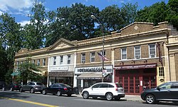
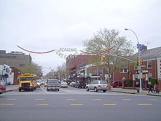
Douglaston has many independently owned and operated restaurants and shops, many of which are located in the area around the intersection of Douglaston Parkway and Northern Boulevard. This area is home to a distinct cultural presence and traditional New York City style delis and pizzerias.
The Douglaston Plaza Shopping Center is a major hub of the community's economic activity. It contains a Fairway Market supermarket (which opened in November 2011), Toys 'R' Us, a Modell's sporting goods store, Macy's, Burger King and the pizza restaurant Grimaldi's.
Transportation
The LIRR station, looking west from the Douglaston Parkway overpass
In the 30 Rock episode "Hiatus", the community stood in for Needmore, Pennsylvania. Mary Hudson, a character in "The Laughing Man", a short story by J. D. Salinger, is from this community. "Machine", the masked character from the 1999 film 8mm, also lived with his mother in Douglaston.
Ozone Park is a neighborhood located in the southwestern section of the borough of Queens, in New York City, New York, United States. It is located next to the Aqueduct Racetrack in South Ozone Park, a popular spot for Thoroughbred racing. The neighborhood was known for its large Italian-American population. Over the years, it has become a very diverse community.
Flushing is a neighborhood in the New York City borough of Queens in the United States. While much of the neighborhood is residential, Downtown Flushing, centered on the northern end of Main Street in Queens, is a large commercial and retail area and is the fourth largest central business district in New York City.
Corona is a neighborhood in the borough of Queens in New York City. It is bordered by Flushing and Flushing Meadows–Corona Park to the east, Jackson Heights to the west, Forest Hills and Rego Park to the south, Elmhurst to the southwest, and East Elmhurst to the north.
Throggs Neck is a neighborhood and peninsula in the southeastern portion of the borough of the Bronx in New York City. It is bounded by the East River and Long Island Sound to the south and east, Westchester Creek on the west, and Baisley Avenue and the Bruckner Expressway on the north.
Forest Hills is a mostly residential neighborhood in the central portion of the borough of Queens in New York City. The north, east, and south boundaries are the Long Island Expressway, Grand Central Parkway, and Union Turnpike, respectively. Google Maps shows the western boundary running roughly along 102nd Street, 67th Avenue, and the Long Island Rail Road's former Rockaway Beach Branch; while the Encyclopedia of New York City defines the western boundary as Junction Boulevard and the former Rockaway Beach Branch. The area was originally referred to as "Whitepot".
Queens Village is a mostly residential middle class neighborhood in the eastern part of the New York City borough of Queens. The Queens Village Post Office serves the ZIP codes of 11427, 11428, and 11429. The neighborhood is part of Queens Community Board 13.
Howard Beach is a neighborhood in the southwestern portion of the New York City borough of Queens. It is bordered to the north by the Belt Parkway and South Conduit Avenue in Ozone Park, to the south by Jamaica Bay in Broad Channel, to the east by 102nd–104th Streets in South Ozone Park, and to the west by 75th Street in East New York, Brooklyn. The area consists mostly of low-rise single-family houses.
Pelham Bay is a middle class residential neighborhood in the borough of the Bronx, in New York City. It is named for Pelham Bay Park, New York City's largest park, which lies on the neighborhood's northeastern border; and for Pelham Bay, a body of water in that park. The neighborhood is bounded roughly by Pelham Parkway on the north, the New England Thruway (I-95) on the east, the Bruckner Expressway (I-95) on the south, and the Hutchinson River Parkway on the west.
Pelham Gardens is a neighborhood located in the Northeast section of the Bronx, New York City. Its boundaries, starting from the north and moving clockwise are East Gun Hill Road to the north and east, Pelham Parkway to the south, and the Dyre Avenue subway to the west. Eastchester Road is the primary thoroughfare through Pelham Gardens.
Rego Park is a neighborhood in the borough of Queens in New York City. Rego Park is bordered to the north by Elmhurst and Corona, the east and south by Forest Hills, and the west by Middle Village. Rego Park's boundaries include Queens Boulevard, the Long Island Expressway, Woodhaven Boulevard, and Yellowstone Boulevard. There is a large Jewish population in the neighborhood, which features high-rise apartment buildings and detached houses, as well as a large commercial zone.
Bayside is a neighborhood in the New York City borough of Queens. The neighborhood is east of Flushing and is part of Queens Community Board 11. CNN Money ranked Bayside as one of the most expensive housing markets nationally when analyzing comparable detached homes throughout the United States. Despite its large housing stock of free-standing homes, it nationally ranks high to very high in population density. These homes give the neighborhood a similar feel to other wealthy Queens neighborhoods such as Douglaston–Little Neck and Whitestone.
Fresh Meadows is a residential neighborhood in the northeastern section of the New York City borough of Queens. Fresh Meadows is located in the south part of Flushing and is bordered to the north by the Fresh Meadows Playground and Horace Harding Expressway, to the west by South Flushing and the sub-neighborhood of Hillcrest, to the east by Cunningham Park, and to the south by Union Turnpike and St. John's University. The neighborhood is part of Queens Community Board 8 and is covered by ZIP Codes 11365 and 11366.
Dongan Hills is a neighborhood located within the New York City borough of Staten Island. It is on the Island's East Shore. Dongan Hills is bounded by Laconia Avenue on the southeast, Jefferson Avenue on the southwest, Richmond Road on the northwest, and Old Town Road to the north. It is adjacent to New Dorp and Grant City to the southwest, Todt Hill to the northwest, Old Town/Concord to the northeast, and South Beach and Midland Beach to the southeast.
Glendale is a neighborhood in the west-central portion of the New York City borough of Queens. It is bounded by Forest Hills and Kew Gardens to the east, Ridgewood to the west, Woodhaven to the south, and Middle Village to the north.
Richmond Hill is a commercial and residential neighborhood located in the southwestern section of the borough of Queens, in New York City, New York, United States. The neighborhood is split between Queens Community Board 9 and 10. The area borders Kew Gardens and Forest Park to the north, Jamaica and South Jamaica to the east, South Ozone Park to the south, and Woodhaven and Ozone Park to the west.
Bedford Park is a residential neighborhood in the northwest Bronx, New York City, between the New York Botanical Garden and Lehman College. Its boundaries, starting from the north and moving clockwise are: Mosholu Parkway to the north, Webster Avenue to the east, East 196th Street to the south, and the Jerome Reservoir and Goulden Avenue to the west.
South Ozone Park is a neighborhood in the southwestern section of the New York City borough of Queens. Adjacently north of JFK Airport, its boundaries extend from the Aqueduct Racetrack eastward to the Van Wyck Expressway. Its main thoroughfare is Rockaway Boulevard. The neighborhood is part of Queens Community Board 10.
The Queens Community Board 11 is a local government in the New York City borough of Queens, encompassing the neighborhoods of Bayside, Douglaston–Little Neck, Auburndale, East Flushing, Oakland Gardens and Hollis Hills. It is delimited by Utopia Parkway to the west, 26th Avenue and Little Neck Bay to the north, the Nassau County border to the east and Horace Harding Expressway, Clearview Expressway and Grand Central Parkway to the south.
Community boards of Queens are New York City community boards in the borough of Queens, which are the appointed advisory groups of the community districts that advise on land use and zoning, participate in the city budget process, and address service delivery in their district.
↑ Kellogg, Craig. "10 Questions With... Deborah Berke", Interior Design (magazine), August 1, 2017. Accessed March 4, 2018. "I grew up in Douglaston, Queens, which has detached single family houses in many styles. It was a kind of idyllic mid-century childhood. I started sketching houses as a child, so the interest in architecture was there from the beginning."
↑ Grosz, George (1983). George Grosz: An Autobiography. New York: Macmillan. p.290. ISBN0025458302.
↑ Duke, Nathan. " Douglaston's Own: Hedda Hopper; Read Patch's profile of the controversial gossip columnist and former community resident.", Bayside Patch, February 8, 2012. Accessed March 4, 2018. "Hedda Hopper may have gotten her Hollywood breakthrough as a silent film actress, but words would eventually be her bread and butter.The famed gossip columnist and one-time Douglaston resident was born as Elda Furry in small town Pennsylvania in 1885.In the early 1900s, she made her Broadway debut and moved to northeast Queens."
↑ Staff. "They Lived Here – Angela Lansbury", Queens Courier, November 30, 2006. Accessed March 4, 2018. "Though she could have never imagined the illustrious career ahead of her, Angela Lansbury dreamed of being an actress as a young girl. A star in films, television, and Broadway, Lansbury was able to appeal to audiences of all kinds. In a career spanning over five decades, she was frequently recognized for her outstanding performances. Interestingly, while trying her hand at Broadway, Lansbury resided in Douglaston."
↑ Weber, Bruce. "Dick Lynch, Giants Star Who Became a Broadcaster, Dies at 72", The New York Times, September 24, 2008. Accessed March 4, 2018. "Dick Lynch, who twice led the National Football League in interceptions as a defensive back for the New York Giants and who later spent 40 years as a radio broadcaster for the team, died Wednesday at his home in the Douglaston section of Queens."
↑ Stagnaro, Angelo. "Thomas Merton in the city", National Catholic Reporter, January 22, 2010. Accessed March 4, 2018. "If one asks who was the most important spiritual thinker of past 100 years, most people, Catholic or not, will more likely say Thomas Merton.... When his family came to America when he was a toddler, they ultimately moved into his maternal grandparents’ home in Queens at 241-16 Rushmore Avenue, Douglaston."
↑ Gay, Verne. "That '70s psycho: Bobby Fischer's fall", Newsday, June 3, 2011. Accessed March 4, 2018. "Fischer was so conflicted by the match that he hid out for days in the Douglaston house of Dr. Anthony Saidy, another chess prodigy, who's interviewed here. "
↑ Staff. "They Lived Here Arthur Treacher", Queens Courier, February 8, 2007. Accessed March 4, 2018. "Treacher made his move to America a permanent one. Around this time, he made Douglaston his residence. His house was located at Hollywood Avenue between Center Drive and East Drive."
This page is based on this Wikipedia article Text is available under the CC BY-SA 4.0 license; additional terms may apply. Images, videos and audio are available under their respective licenses.