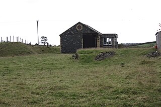
Donegore is the name of a hill, a townland, a small cluster of residences, and a civil parish in the historic barony of Antrim Upper, County Antrim, Northern Ireland. Donegore lies approximately 5 miles (8 km) east of Antrim town. 154 acres of the townland lies in the civil parish of Grange of Nilteen.

Saul is the name of a townland and civil parish in County Down, Northern Ireland.
Ballynoe is a small settlement and townland south of Downpatrick in County Down, Northern Ireland. It is situated in the civil parish of Bright and historic barony of Lecale Upper.

Rathfriland is a town in County Down, Northern Ireland. It is a hilltop Plantation of Ulster settlement between the Mourne Mountains, Slieve Croob and Banbridge.

Drumbeg is a small village, townland and civil parish on the south bank of the River Lagan in County Down, Northern Ireland. The village is covered by the Lisburn City Council area and forms part of the suburban fringe of Belfast.

Lambeg is a small village and civil parish in County Antrim, Northern Ireland. Located between Belfast and Lisburn, it was once a small rural village, but is now within the Greater Belfast conurbation. Lambeg is also an electoral ward of Lisburn Council. In the 2001 Census it had a population of 60 people. The civil parish of Lambeg covers areas of County Down as well as County Antrim.

Ballyrashane is a small village and civil parish outside Coleraine, County Londonderry, Northern Ireland. The civil parish of Ballyrashane covers areas of County Antrim, as well as County Londonderry. It is part of Causeway Coast and Glens district.

Tullylish is a small village, townland and civil parish in County Down, Northern Ireland. It sits on the River Bann, along the main road between the towns of Banbridge and Portadown. In the 2001 Census it had a population of 105 people. It lies within the civil parish of Tullylish and Banbridge District.

Lislea is a small village and townland near Slieve Gullion in County Armagh, Northern Ireland. It is within the civil parish of Killevy and the historic barony of Orior Upper. Today it is within the Newry, Mourne and Down District Council area. It borders the townlands of Ballard, Carricnagalliagh, Aghmakane, Duburren and Drumilly. In the 2001 Census it had a population of 84 people.
Sheeptown is a small village and townland in County Down, Northern Ireland. It lies to the northeast of Newry, on the old road between Newry and Rathfriland. Historically, the townland was called Athcruthain. In the 2001 Census it had a population of 204 people. It is part of the Newry and Mourne District Council area.
Kilcoo is a small village and civil parish in County Down, Northern Ireland. It lies between Rathfriland and Castlewellan and is within the Newry, Mourne and Down District Council area. Kilcoo had a population 1415 people in the 2001 Census.
Desertcreat is a parish and a townland in County Tyrone, Northern Ireland. The civil parish of Desertcreat is in the eastern part of County Tyrone in the barony Dungannon Upper, immediately south of the parish of Derryloran, which contains the town of Cookstown, and immediately north of the parish of Pomeroy. The parish has a Church of Ireland Church in the townland of Desertcreat.
Annaclone is a village and civil parish between Rathfriland and Banbridge in south County Down, Northern Ireland, about 7 km south-east of Banbridge. The village is situated in the townlands of Ardbrin and Tullintanvally and both it and the civil parish are located in the historic barony of Iveagh Upper, Upper Half. It had a population of 150 people in the 2011 Census.
Dufferin is a historic barony in County Down, Northern Ireland. It is on the southern half of the west shore of Strangford Lough, and is bordered by three other baronies: Castlereagh Lower to the north; Castlereagh Upper to the west; and Lecale Lower to the south.

Ballinderry is a civil parish and townland in County Antrim, Northern Ireland. It is situated in the historic barony of Massereene Upper.

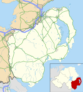
Iveagh Upper, Upper Half is the name of a barony in County Down, Northern Ireland. It was created by 1851 with the division of the barony of Iveagh Upper into two. It lies to the west and south of the county, split in half by the Lordship of Newry. It is bordered by six other baronies: Mourne to the south; Iveagh Upper, Lower Half to the east; Iveagh Lower, Lower Half and Iveagh Lower, Upper Half to the north; and Orior Lower and Orior Upper to the west.

Derriaghy,, , is a townland and civil parish in County Antrim, Northern Ireland, 5.5 miles (9 km) south-west of Belfast city centre. The townland is situated in the historic barony of Belfast Upper and the civil parish covers areas of both Belfast Upper and the barony of Massereene Upper.
Legacurry is a townland of 100 acres in County Down, Northern Ireland. It is situated in the civil parish of Drumbo and the historic barony of Castlereagh Upper.
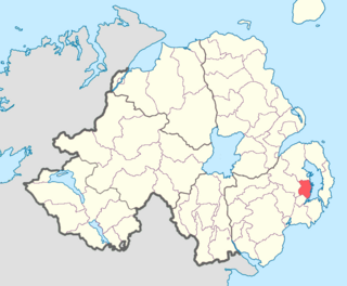
Drumballyroney is a civil parish in County Down, Northern Ireland. It is situated in the historic barony of Iveagh Upper, Lower Half.


