
Somalia, officially the Federal Republic of Somalia is a sovereign country located in the Horn of Africa. It is bordered by Ethiopia to the west, the Gulf of Aden to the north, the Guardafui Channel and Somali Sea to the east, and Kenya to the southwest. The country claims a border with Djibouti through the disputed territory of Somaliland. Somalia has the longest coastline on Africa's mainland, and its terrain consists mainly of plateaus, plains, and highlands. Climatically, hot conditions prevail year-round, with periodic monsoon winds and irregular rainfall.

Sanaag is an administrative region (gobol) in northern Somalia, within the autonomous region of Somaliland. Sanaag has a long coastline facing the Gulf of Aden to the north, and is bordered by the Somali regions of Woqooyi Galbeed, Togdheer, Sool and Bari. Its capital city is Erigavo.

Togdheer is an administrative region (gobol) in northern Somalia, although it is de facto part of the Somaliland region, a self-declared state but internationally unrecognized.

Bari is an administrative region (gobol) in northeastern Somalia.

Nugal is an administrative region (gobol) in northeastern Somalia.

Mudug is an administrative region (gobol) in north-central Somalia. The population of Mudug is 131,455 as of 2005.

Galguduud is an administrative region (gobol) of Galmudug state in central Somalia. Its administrative capital is Dusmareb.
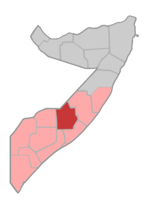
Hiran is an administrative region (gobol) in central Somalia. Mainly inhabited by the Hawadle.

Bakool is a region (gobol) in southwestern Somalia.

Middle Shabelle is an administrative region (gobol) in southern Somalia.

Benaadir is an administrative region (gobol) in southeastern Somalia. It covers the same area as the city of Mogadishu, Somalia's capital. It is bordered to the northwest by the Shabelle river, and to the southeast by the Somali Sea. Although by far the smallest administrative region in Somalia, it has the largest population, estimated at 1,650,227 in 2014.

Gedo is an administrative region (gobol), formerly part of the historic Upper Juba Region in southern Somalia. Its regional capital is Garbahaarreey. Gedo is a region created in 1970s and is bordered by the Ogaden in Ethiopia, the North Eastern Province in Kenya, and the Somali regions of Bakool, Bay, Jubbada Dhexe, and Jubbada Hoose further down east. The southern parts of Gedo, west of the Jubba River, used to be part of the old British Trans-Juba region during half of the seventy years of colonial era in Africa from 1890 to 1960. The British and Italians fought over twice in this area of Horn of Africa. The first democratically elected governor of the administrative region occurred in a grassroots effort with Hussein Farey's admission into office in 2008.

Lower Juba is an administrative region (gobol) in southern Somalia. With its capital at Kismayo, it lies in the autonomous Jubaland region. It has green forests and wild life animals such as lions, giraffes, hippos, crocodiles, and hyenas.

The Somali Regional State, officially known as the Somali West, is the second largest and easternmost of the Nine regions (kilimo) of Ethiopia. The state borders the Ethiopian states of Afar and Oromia and the chartered city Dire Dawa to the west, as well as Djibouti to the north; Somalia to the north, east, and south; and Kenya to the southwest.

Greater Somalia is a concept to unite all Somali speaking nations comprising the regions in or near the Horn of Africa in which ethnic Somalis live and have historically inhabited. The territory historically encompassed British Somaliland, Italian Somaliland, French Somaliland Now [Djibouti], the Somali Region in the Ethiopian Empire and the Northern Frontier District Now North Easten Province in the Colony and Protectorate of Kenya. At the present day, it encompasses Northern De facto Somaliland, southern Somalia, eastern Djibouti, the Somali region and Dire Dawa in Ethiopia, and the Lamu, Garissa, Wajir and Mandera Counties in Kenya.

Galkayo is the capital of the north-central Mudug region of Somalia. The city of Galkayo is divided into two administrative areas separated by a distinct boundary, with 3 of the 4 districts governed by the Puntland State and one southern district governed by Galmudug state. It is the third largest city in the whole of Somalia.

The North Eastern Province is one of the former provinces in Kenya. It has a land area of 127,358.5 km2, with its capital at Garissa. Previously known as the Northern Frontier District (NFD),, Now The North Eastern Province territory was carved out of the present-day southern Somalia during the colonial period. It is and has historically been exclusively inhabited by ethnic Somalis.

Somalia is officially divided into eighteen (18) administrative regions, which in turn are subdivided into ninety (90) districts.
The Shifta War (1963–1967) was a secessionist conflict in which ethnic Somalis in the Northern Frontier District (NFD) of Kenya attempted to secede from Kenya join with their fellow Somalis in a Greater Somalia. The Kenyan government named the conflict "shifta", after the Somali word for "bandit", as part of a propaganda effort. The Kenyan counter-insurgency General Service Units forced civilians into "protected villages" as well as killing many livestock kept by the pastoralist Somalis. The war ended in 1967 when Muhammad Haji Ibrahim Egal, Prime Minister of the Somali Republic, signed a ceasefire with Kenya at the Arusha Conference on October 23, 1967. However, the violence in Kenya deteriorated into disorganised banditry, with occasional episodes of secessionist agitation, for the next several decades. The war and violent clampdowns by the Kenyan government caused large-scale disruption to the way of life in the district, resulting in a slight shift from pastoralist and transhumant lifestyles to sedentary, urban lifestyles. Government records put the official death toll in the thousands but NGO's say more than 10,000 lives were lost.

Maakhir, officially the Maakhir State of Somalia was a short-lived quasi-state in northern Somalia. In January 2009, it was incorporated into Puntland.