Rabdhure District | |
|---|---|
 | |
| Country | |
| Region | Bakool |
| Capital | Rab Dhuure |
| Time zone | UTC+3 (EAT) |
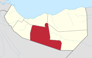
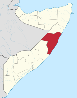
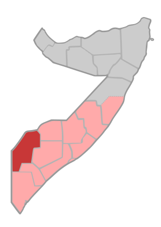
Rabdhure District (Somali : Degmada Rabdhuure) is a district in the southwestern Bakool region of Somalia.
Rabdhure District | |
|---|---|
| | |
| Country | |
| Region | Bakool |
| Capital | Rab Dhuure |
| Time zone | UTC+3 (EAT) |
Rabdhure District (Somali : Degmada Rabdhuure) is a district in the southwestern Bakool region of Somalia.
Somaliland, officially the Republic of Somaliland, is an unrecognised country in the Horn of Africa. It is located in the southern coast of the Gulf of Aden and bordered by Djibouti to the northwest, Ethiopia to the south and west, and Somalia to the east. Its claimed territory has an area of 176,120 square kilometres (68,000 sq mi), with approximately 6.2 million people as of 2024. The capital and largest city is Hargeisa.

Sanag is an administrative region (gobol) in north eastern Somaliland. Sanaag has a long coastline facing the Gulf of Aden to the north, and is bordered by the region of Sahil to the west, Sool to the south and Somalia to the east. The region is disputed by the self-declared Republic of Somaliland and Puntland, a Federal Member State of Somalia. Its capital city is Erigavo. Sanaag is the largest region of Somaliland, accounting for 35% of Somaliland's total land area.
Togdheer is an administrative region (gobol) in central Somaliland. Togdheer is bordered by Maroodi Jeex to the west, Saaxil to the north, Sanaag to the northeast, Sool to the east and Ethiopia to the south. Its capital is Burao.

Marodi Jeh is an administrative region (gobol) in western Somaliland. It is the most populous region of the country. It is bordered by Awdal to the west, Sahil to the north, Togdheer to the east and Ethiopia to the south. Marodi Jeh was created by splitting the previously existing region (gobolka). In 2007 the region of Woqooyi Galbeed was renamed to Maroodi Jeex.

Bari is an administrative region (gobol) in northeastern Somalia comprising six districts: Qandala, iskushuban, Aluula, Bosaso, bandar Belyla, and Qardho.
Mudug is an administrative region (gobol) in north-central Somalia. The population of Mudug is 131,455 as of 2005.

Galguduud is an administrative region (gobol) of Galmudug state in central Somalia. Its administrative capital is Dusmareb. The largest town in the region is El Buur, which lies at the centre of the region.

Bakool is a region (gobol) in southwestern Somalia.

Lower Shabelle is an administrative region (gobol) in southern Somalia.

Banaadir is an administrative region (gobol) in southeastern Somalia. It covers the same area as the city of Mogadishu, which serves as the capital. It is the only region in the country not belonging to any of the six states. It is bordered to the northwest by the Shabelle river, and to the southeast by the Indian Ocean. Although by far the smallest administrative region in Somalia, it has the largest population, estimated at 1,650,227 in 2014.
Gedo is an administrative region (gobol) in Jubaland, southern Somalia. Its regional capital is Garbahaarreey. The region was formed during 1974 and is bordered by the Ogaden in Ethiopia, the North Eastern Province in Kenya, and the Somali regions of Bakool, Bay, Jubbada Dhexe, and Jubbada Hoose further down east. The southern parts of Gedo, west of the Jubba River, used to be part of the old British Trans-Juba region during half of the seventy years of colonial era in Africa from 1890 to 1960. The British and Italians fought twice over this area.

Lower Juba is an administrative region (gobol) in southern Somalia. With its capital at Kismayo, it lies in the autonomous Jubaland region. It has green forests and wildlife including lions, giraffes, hippos, crocodiles, and hyenas.

Greater Somalia sometimes also called Greater Somaliland is the geographic location comprising the regions in the Horn of Africa in which ethnic Somalis live and have historically inhabited.
The Arap or Arab clan is a major Northern Somali clan of the wider Isaaq clan family. The Arap predominantly live on the middle and southwest side of Hargeisa and in the Baligubadle district Hawd region) of Somaliland, with its capital Baligubadle being an exclusively Arap territory. The territory of the clan extends to Ethiopia, in the area of Faafan, Gursum and Dhagahle. The Abdalle Arab, a sub-clan of the Arap clan is based in the Togdheer, Sahil. The Celi Arab, a sub-clan of the Arap clan is based in Maroodi Jeex Hargeisa Muuse celi arab living also Bakool South West State of Somalia Rabdhure Elbarde, They also live Fafan Zone Gursum, Somali Sheekh cismaan Arab based in Nogob Zone Jarar Zone regions.

The Isaaq is a major Somali clan. It is one of the largest Somali clan families in the Horn of Africa, with a large and densely populated traditional territory.

Somalia is officially divided into 18 administrative regions. These are in turn subdivided into seventy-two districts
Hudur is a town in the south western Bakool region of Somalia, inhabited by Mirifle majority people Hadamo with Jiroon of the Rahanweyn tribes. It serves as the province's capital and the center of the Hudur District. The town is heart of the Maay language and Rahanweyn culture. Huddur is also known for being the hometown of influential politicians and leaders of Somalia.

The 2009 timeline of events in the Somalia War (2006–2009) during January 2009 is set out below. From the beginning of February the timeline of events in the Somali Civil War (2009–present) is set out following the conclusion of the previous phase of the civil war.
Rab Dhuure, also known as Rabdhure, is a town in the southwestern Bakool region of Somalia and capital of the Rabdhure District. Rabdhuure is one of the five districts in Bakool region of South West State.
On June 27, 2021, militants from al-Shabaab attacked Somali soldiers and civilian militiamen at a military base in Wisil, Mudug, Somalia. At least 17 soldiers and 13 civilians were killed in the attack, along with dozens of al-Shabaab fighters.
| | This Somalia location article is a stub. You can help Wikipedia by expanding it. |