Burhakaba | |
|---|---|
 | |
| Country | |
| Region | Bay |
| Capital | Burhakaba |
| Time zone | UTC+3 (EAT) |
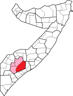
Burhakaba District (Somali : Degmada Buurhakaba) is a district in the southern Bay region of Somalia. Its capital is Burhakaba.
Burhakaba | |
|---|---|
| | |
| Country | |
| Region | Bay |
| Capital | Burhakaba |
| Time zone | UTC+3 (EAT) |
Burhakaba District (Somali : Degmada Buurhakaba) is a district in the southern Bay region of Somalia. Its capital is Burhakaba.

Marodi Jeh is an administrative region (gobol) in western Somaliland. It is the most populous region of the country. It is bordered by Awdal to the west, Sahil to the north, Togdheer to the east and Ethiopia to the south. Marodi Jeh was created by splitting the previously existing region (gobolka). In 2007 the region of Woqooyi Galbeed was renamed to Maroodi Jeex.

Galguduud is an administrative region (gobol) of Galmudug state in central Somalia. Its administrative capital is Dusmareb. The largest town in the region is El Buur, which lies at the centre of the region.

Lower Shabelle is an administrative region (gobol) in southern Somalia.

Banaadir is an administrative region (gobol) in southeastern Somalia. It covers the same area as the city of Mogadishu, which serves as the capital. It is the only region in the country not belonging to any of the six states. It is bordered to the northwest by the Shabelle river, and to the southeast by the Indian Ocean. Although by far the smallest administrative region in Somalia, it has the largest population, estimated at 1,650,227 in 2014.

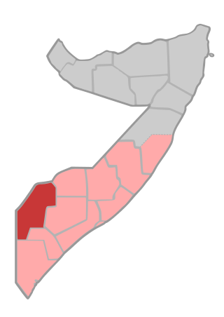
Bay is an administrative region (gobol) in southern Somalia.
Gedo is an administrative region (gobol) in Jubaland, southern Somalia. Its regional capital is Garbahaarreey. The region was formed during 1974 and is bordered by the Ogaden in Ethiopia, the North Eastern Province in Kenya, and the Somali regions of Bakool, Bay, Jubbada Dhexe, and Jubbada Hoose further down east. The southern parts of Gedo, west of the Jubba River, used to be part of the old British Trans-Juba region during half of the seventy years of colonial era in Africa from 1890 to 1960. The British and Italians fought twice over this area.

Somalia is officially divided into 18 administrative regions. These are in turn subdivided into seventy-two districts
Burhakaba is a town located in the Bay region in Somalia.

The Ethiopian invasion of Somalia, also known as the Ethiopian occupation of Somalia or the Ethiopian intervention in the Somali Civil War, was an armed conflict that lasted from late 2006 to early 2009. It began when military forces from Ethiopia, supported by the United States, invaded Somalia to depose the Islamic Courts Union (ICU) and install the Transitional Federal Government (TFG). The conflict continued after the invasion when an anti-Ethiopian insurgency emerged and rapidly escalated. During 2007 and 2008, the insurgency recaptured the majority of territory lost by the ICU.

The 2006 Islamic Courts Union offensive is the period in the Somali Civil War that began in May 2006 with the Islamic Courts Union's (ICU) conquest of Mogadishu from the Alliance for the Restoration of Peace and Counter-Terrorism (ARPCT) and continued with further ICU expansion in the country. Following the outbreak of the war on December 21, 2006; by December 24, direct Ethiopian intervention in the conflict in support of the Transitional Federal Government (TFG) was no longer denied by the Ethiopian government. The Eritrean government denied any involvement despite Ethiopian claims to the contrary.
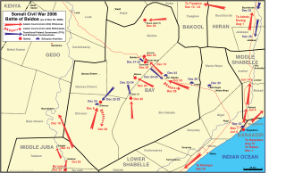
The Battle of Baidoa began on 20 December 2006 when the Somali transitional federal government forces (TFG) allied with Ethiopian forces stationed there attacked advancing Islamic Courts Union (ICU) forces along with 500 alleged Eritrean troops and mujahideen arrayed against them.
The timeline of events in the War in Somalia during 2006 is set out below.

The siege of Baidoa was a military confrontation lasting from July 2008 to January 2009 during the Ethiopian occupation of Somalia, during which al-Shabaab laid siege to the headquarters of the Ethiopian backed Somali Transitional Federal Government (TFG).

Hizbul Islam, also known as Hizbul Islaami, Hisbi Islam, or Hezb-ul Islam, was a Somali Islamist group formed after four Islamist groups merged to oppose the new Somali government of President Sheikh Sharif Ahmed. The four groups were: Hassan Aweys' the ARS-A, Jabhatul Islamiya, Hassan Abdullah Hersi al-Turki's the Mu'askar Ras Kamboni and Muaskar Anole, the Marehan clan's Militia and Harti clan's militia. These groups previously took part in the fighting against the Ethiopian occupation of Somalia.

This is a 2014 timeline of events in the Somali Civil War (2009–present).

Healthcare in Somalia is largely in the private sector. It is regulated by the Ministry of Health of the Federal Government of Somalia. In March 2013, the central authorities launched the Health Sector Strategic Plans (HSSPs), a new national health system that aims to provide universal basic healthcare to all citizens by 2016. Somalia has the highest prevalence of mental illness in the world, according to the World Health organization. Some polls have ranked Somalis as the happiest people in Sub-Saharan Africa.
Lego, is a town located in Bay, Somalia. It is situated 100 kilometres northwest of the capital Mogadishu and approximately 20 km west of Yaqbiriweyne and 54 km east of Burhakaba.
This is a 2010 timeline of events in the Somali Civil War (2009–present).
The Gaalje'el, , or Habar Tigaalle is one of the largest Somali clans, whose origins traces back to Samaale. The Galje'el clan belong to the major Saransor clans who also are a sub clan of the wider Gardhere Samaale clans.
Musa Nur Amin is a Somali politician who served in the Transitional Federal Parliament during the 2000s. On 5 January 2008, he was appointed Somalia's Minister of Internal Affairs, placing him in command of the Somali Police Force. In the 1980s, Amin was the director-general/permanent secretary of the Ministry of Marine Transport and Ports. In the late 1990s and early 2000s, he was the secretary-general of the United Somali Congress, a prominent rebel group.
| | This Somalia location article is a stub. You can help Wikipedia by expanding it. |