Eagle River, Anchorage

Last updated

Eagle River is a community within the Municipality of Anchorage situated on the Eagle River, for which it is named, between Joint Base Elmendorf-Richardson (JBER) and Chugach State Park in the Chugach Mountains. Its ZIP code is 99577. Settled by homesteaders, Eagle River has been annexed to the Municipality of Anchorage since the 1970s—a relationship that is, at times, complicated. [1] [2] [3] On the one hand, Eagle River functions as an Anchorage suburb--many Eagle River residents work, shop, and participate in community life in the Anchorage Bowl. On the other hand, the community is itself a significant business hub between Wasilla and Anchorage, offering shopping, restaurants, recreation and employment. [4] Much of the community is made up of residents from nearby Joint Base Elmendorf-Richardson. Secession efforts have from time to time gained traction by residents who would like Eagle River legally regarded as a separate community. Eagle River also has a close relationship with its neighboring community to the north, Chugiak, with which it shares some history. If Eagle River were not part of the Municipality of Anchorage, it would be classified as one of the five largest cities in Alaska.

Contents

Aerial view, looking northeasterly, of Eagle River and the surrounding area. View includes portions of Chugach State Park, the Glenn Highway, Joint Base Elmendorf-Richardson and Knik Arm. The river of Eagle River itself can be seen following a winding path to the south of the settlement. Eagle River, Alaska Aerial.jpg
Aerial view, looking northeasterly, of Eagle River and the surrounding area. View includes portions of Chugach State Park, the Glenn Highway, Joint Base Elmendorf-Richardson and Knik Arm. The river of Eagle River itself can be seen following a winding path to the south of the settlement.
View of the mountainous scenery found in abundance in the upper Eagle River valley. Parque Eagle River, Anchorage, Alaska, Estados Unidos, 2017-09-01, DD 04-06 PAN.jpg
View of the mountainous scenery found in abundance in the upper Eagle River valley.

History

The Eagle River (and Chugiak) area was settled by homesteaders and prospered on agricultural activities. The name Eagle River was first reported in 1939 by the U.S. Geological Survey, and the Eagle River post office was established in 1961.

In 1964, the state legislature first divided the state into seven boroughs. Over the next decade, many area residents objected to the Chugiak-Eagle River area being lumped in as part of a Greater Anchorage-Area Borough. The Chugiak-Eagle River Borough was established in 1974, only to be dissolved shortly thereafter when the arrangement was ruled unconstitutional by the Alaska Supreme Court. [5]

Despite some local opposition, both Chugiak and Eagle River were annexed to the Municipality of Anchorage when the City of Anchorage and the Greater Anchorage Area Borough were unified in 1975. Efforts to secede from the Municipality surfaced around 2000, and then became less prominent for a while as the community saw an influx of residents with social and economic ties to Anchorage and nearby Joint Base Elmendorf–Richardson. [6] [7] However, secession talks began again in 2019 from a small group of community members. [8]

Geography

Upper Eagle River valley, with Hiland Road neighborhoods in the left foreground and the Chugach Mountains in the background. Eagle River Valley Aerial, Alaska.jpg
Upper Eagle River valley, with Hiland Road neighborhoods in the left foreground and the Chugach Mountains in the background.

Mount Baldy, a 3,218-foot peak in Chugach State Park is a popular hiking and hang-gliding area. [9] [10]

The Eagle River runs through the southern end of the community.

Neighborhoods along the Glenn Highway and Old Glenn Highway corridor are level or sloping, rising towards the Chugach Mountains east of the Old Glenn Highway. The remainder of the community lies along the canyon of the Eagle River; some neighborhoods built in the late 20th century and early 21st century near the Briggs Bridge are built very close to the bottom of the canyon. Neighborhoods along the northern portions of Eagle River, plus Hiland Road and Eagle River Road east of the curve where the road leaves the section line and descends into the canyon, mainly consist of houses built across the mountainsides. Wallace Mountain, on the far northeast corner of the community's road system, is home to several radio station transmitters and towers at the 1,900 feet (580 m) level.

Climate

Eagle River's average temperatures in January range from 6 °F (−14 °C) to 20 °F (−7 °C); in summer, temperatures range from 50 °F (10 °C) to 70 °F (21 °C). Annual precipitation is 15.9 inches (40 cm), with 69 inches (180 cm) of snowfall. The bulk of the snowfall is usually from mid-October through December, with fewer snowstorms from January through April. On average, the area experiences 2 to 3 "chinooks" - a warm, dry wind that melts much of the snow and creates a minor thaw - during the winter months. Springtime is generally referred to as "break up" in the area and further north, referring to the breaking up of the ice on rivers and lakes. Local lore holds that seedlings should not be planted outdoors until after Memorial Day in May, and even then temperatures should be watched for light frost until June.

Climate data for Eagle River, Alaska
MonthJanFebMarAprMayJunJulAugSepOctNovDecYear
Record high °F (°C)50
(10)
52
(11)
55
(13)
70
(21)
77
(25)
84
(29)
83
(28)
84
(29)
70
(21)
65
(18)
55
(13)
53
(12)
84
(29)
Mean daily maximum °F (°C)22
(−6)
26
(−3)
34
(1)
44
(7)
54
(12)
62
(17)
65
(18)
63
(17)
55
(13)
40
(4)
27
(−3)
23
(−5)
43
(6)
Mean daily minimum °F (°C)9
(−13)
11
(−12)
16
(−9)
27
(−3)
37
(3)
45
(7)
49
(9)
47
(8)
39
(4)
26
(−3)
14
(−10)
11
(−12)
28
(−3)
Record low °F (°C)−23
(−31)
−29
(−34)
−17
(−27)
−5
(−21)
20
(−7)
33
(1)
40
(4)
32
(0)
16
(−9)
−3
(−19)
−18
(−28)
−18
(−28)
−29
(−34)
Average precipitation inches (mm)0.60
(15)
0.74
(19)
0.71
(18)
0.33
(8.4)
0.64
(16)
1.00
(25)
2.02
(51)
2.37
(60)
2.45
(62)
1.75
(44)
1.11
(28)
1.34
(34)
15.06
(380.4)
Source: [11]
Climate data for Eagle River Gakona Circle, Alaska, 1991–2020 normals: 567ft (173m)
MonthJanFebMarAprMayJunJulAugSepOctNovDecYear
Mean daily maximum °F (°C)20.3
(−6.5)
26.9
(−2.8)
33.4
(0.8)
46.2
(7.9)
58.0
(14.4)
64.4
(18.0)
66.7
(19.3)
63.2
(17.3)
53.5
(11.9)
39.9
(4.4)
25.5
(−3.6)
22.0
(−5.6)
43.3
(6.3)
Daily mean °F (°C)14.7
(−9.6)
20.1
(−6.6)
24.9
(−3.9)
37.5
(3.1)
48.0
(8.9)
55.1
(12.8)
58.5
(14.7)
55.6
(13.1)
46.9
(8.3)
34.1
(1.2)
20.6
(−6.3)
16.8
(−8.4)
36.1
(2.3)
Mean daily minimum °F (°C)9.2
(−12.7)
13.4
(−10.3)
16.4
(−8.7)
28.8
(−1.8)
38.0
(3.3)
45.8
(7.7)
50.3
(10.2)
48.0
(8.9)
40.4
(4.7)
28.4
(−2.0)
15.7
(−9.1)
11.6
(−11.3)
28.8
(−1.8)
Average precipitation inches (mm)0.97
(25)
1.13
(29)
0.85
(22)
0.55
(14)
0.90
(23)
1.14
(29)
2.09
(53)
2.82
(72)
2.67
(68)
1.74
(44)
1.58
(40)
1.23
(31)
17.67
(450)
Average snowfall inches (cm)12.50
(31.8)
11.70
(29.7)
8.90
(22.6)
4.50
(11.4)
0.40
(1.0)
0.00
(0.00)
0.00
(0.00)
0.00
(0.00)
0.40
(1.0)
3.50
(8.9)
12.30
(31.2)
16.30
(41.4)
70.5
(179)
Source: NOAA [12]
Climate data for Eagle River Nature Centre, Alaska, 1991–2020 normals, 2007-2020 snowfall: 520ft (158m)
MonthJanFebMarAprMayJunJulAugSepOctNovDecYear
Mean daily maximum °F (°C)20.9
(−6.2)
28.0
(−2.2)
35.3
(1.8)
47.1
(8.4)
58.0
(14.4)
65.4
(18.6)
67.4
(19.7)
64.5
(18.1)
56.0
(13.3)
42.1
(5.6)
26.4
(−3.1)
23.3
(−4.8)
44.5
(7.0)
Daily mean °F (°C)13.7
(−10.2)
19.8
(−6.8)
25.0
(−3.9)
36.8
(2.7)
46.9
(8.3)
54.6
(12.6)
57.7
(14.3)
54.7
(12.6)
46.6
(8.1)
33.9
(1.1)
19.7
(−6.8)
16.1
(−8.8)
35.5
(1.9)
Mean daily minimum °F (°C)6.4
(−14.2)
11.6
(−11.3)
14.7
(−9.6)
26.5
(−3.1)
35.7
(2.1)
43.7
(6.5)
47.9
(8.8)
44.9
(7.2)
37.2
(2.9)
25.7
(−3.5)
12.9
(−10.6)
8.9
(−12.8)
26.3
(−3.1)
Average precipitation inches (mm)2.26
(57)
1.64
(42)
1.56
(40)
0.76
(19)
0.94
(24)
1.31
(33)
1.68
(43)
2.62
(67)
3.64
(92)
2.46
(62)
1.72
(44)
1.96
(50)
22.55
(573)
Average snowfall inches (cm)12.1
(31)
16.0
(41)
9.7
(25)
6.4
(16)
0.5
(1.3)
0.0
(0.0)
0.0
(0.0)
0.0
(0.0)
0.6
(1.5)
3.6
(9.1)
11.6
(29)
18.0
(46)
78.5
(199.9)
Source 1: NOAA [13]
Source 2: XMACIS2 (snowfall) [14]

Demographics

Historical population
CensusPop.Note
1960 130
1970 2,4371,774.6%
U.S. Decennial Census [15]

Eagle River first appeared on the 1960 U.S. Census as an unincorporated village, and again in 1970. It was annexed into Anchorage in 1975.

The 2000 census found a population of 22,236 in Eagle River and an additional 8,000 in the settlements northeast of Eagle River: Chugiak, Birchwood, Peters Creek, Thunderbird Falls and Eklutna. [16] About 30,000 people live in the Eagle River and Chugiak areas, on both sides of the Glenn Highway. Many personnel from Joint Base Elmendorf-Richardson (and formerly from their predecessors, Fort Richardson and Elmendorf Air Force Base) live in Eagle River, and many of the area's civilian residents additionally commute to jobs in the "Anchorage bowl."

Economy

Eagle River is the shopping hub between Anchorage and the smaller Mat-Su cities, Palmer and Wasilla. The last decade has seen two major improvements in local services: shopping and the availability of medical and dental services. The number of local restaurants available almost doubled over the same 10-year span. The local movie theater reopened in 2006 with six screens, then closed down in December 2011. As of 2006, leading industries in the community were the service industry, followed by trade (retail) and government (mainly working at public schools for the Anchorage School District). [17]

Some local homes and businesses were heavily damaged during the 2018 Anchorage earthquake and had to be repaired and renovated or abandoned. Gruening Middle School and Eagle River Elementary School had to close down for the remainder of the school year due to damage. [18] [19] [20]

Arts and culture

Annual community events include a Fourth of July celebration held at Lion's Park, and the Bear Paw Festival, which is in July and is celebrated with multiple events throughout Eagle River.

The Bear Paw Festival kicks off on Thursday evening with the Miss Bear Paw pageant held at the Steve Primis Auditorium at Chugiak High School. This scholarship pageant sponsored by the Chugiak-Eagle River Chamber of Commerce also presents awards for Bear Paw Princess, Official Escort, Best Costume with an Alaskan Theme and Miss Congeniality. The Sleeping Lady Mountain Lions Club provides a Community Service Award scholarship. Saturday morning there is a 5k foot race, followed by a parade. A Renaissance anachronistic group does performances on Saturdays and Sundays.

Education

Eagle River has numerous public, parochial and charter school programs available for K-12 grades. The public school district is the Anchorage School District (ASD). ASD schools serving Eagle River are: Eagle River Elementary, Ravenwood Elementary, Alpenglow Elementary, Homestead Elementary, Firelake Elementary, Chugiak Elementary, and Birchwood Elementary, Gruening Middle School, Mirror Lake Middle School, Eagle River High School, and Chugiak High School (which is located northeast of town). (The town is zoned such that roughly half of local public high school students go to Eagle River High School; the other half attends Chugiak High School. However, due to damage from the 2018 Anchorage earthquake, Eagle River Elementary and Gruening Middle School, officials closed both schools for repairs through at least the 2019-2020 school year, with displaced students accommodated by other ASD schools. Both schools are currently open for the 2021–22 school year. [21] Homeschooling is also a popular form of education in the area, both through home-based charter schools and independently.

The University of Alaska Anchorage provides classes in the area and formerly had a campus at the Eagle Center building, adjacent to the middle Glenn Highway interchange. In 2019, the university chose not to renew its lease, but continues to provide classes at local public school locations. [22] There is also a local bible college.

Sports

VFW Post 9785, located near the middle Glenn Highway interchange, serves as the first checkpoint for the Iditarod Trail Sled Dog Race. First iditarod checkpoint.JPG
VFW Post 9785, located near the middle Glenn Highway interchange, serves as the first checkpoint for the Iditarod Trail Sled Dog Race.

There is a lot of local interest in sports: hockey, both indoor and outdoor soccer, baseball, softball, basketball, football, swimming/diving, hiking, and cross-country running and skiing. A bike trail runs alongside the Glenn Highway from Anchorage past Eagle River and to Chugiak. Sidewalks are available and kept clear most of the winter in the downtown area for walking and jogging along the Old Glenn Highway and Business Boulevard. Cross-country skiing trails are available along Birchwood Road near Chugiak High School and recently trails have been put in around Eagle River High School. Hockey, figure skating, leisure skating, and indoor soccer are available at the Harry J. McDonald Memorial Center, which hosted seven games at the 1989 World Junior Ice Hockey Championships. Outdoor soccer is available at the Russell Oberg Soccer Complex. Chugiak Youth Sports Association (CYSA) is a local non-profit organization that offers recreational team sport opportunities to the youth of Chugiak and Eagle River including soccer, basketball, volleyball and flag football. Eagle River Soccer Club (ERSC) provides pre-competitive soccer (U9 and U10) and recreational youth and adult leagues. Chugiak Soccer Club (CSC) provides competitive soccer for U11-U19 soccer players.

Popular local activities include rafting, hiking, skiing and exploring the mountains. One of the more popular local hikes is up Mount Baldy, which overlooks the town. There is little fishing in the river, but anglers do gather at Fire and Mirror Lakes.

The 1996 Arctic Winter Games were held in Chugiak and Eagle River.

Media

The Chugiak-Eagle River Star is a weekly newspaper that serves Eagle River, Chugiak, Eklutna, Peters Creek and Birchwood. [23] The newspaper was founded in 1971 by Lee B. Jordan, who for decades remained active in the community as an authority on local history. He died in 2018. [24] [25]

The Star is part of the Binkley Company family of newspapers and shares reporting resources with its nearby sister publication, the Anchorage Daily News. [26]

The ECHO is a community magazine focused on the same areas. [27]

From 1958 through 1973, The Knik Arm Courier covered the area. The Chugiak-Eagle River Historical Society maintains an online archives, saying, "The Knik Arm Courier, established by James and Marie McDowell in 1958, was published through 1973 and is a reliable source of information from that period in Chugiak-Eagle River’s history." [28]

Related Research Articles

<span class="mw-page-title-main">Knik River, Alaska</span> CDP in Alaska, United States

Knik River is a census-designated place (CDP) in Matanuska-Susitna Borough in the U.S. state of Alaska. Located 15 miles southeast from Palmer along the Knik River, it is part of the Anchorage, Alaska Metropolitan Statistical Area. The population was 792 at the 2020 census, up from 744 in 2010.

<span class="mw-page-title-main">Palmer, Alaska</span> City in Alaska, United States

Palmer is a city in and the borough seat of the Matanuska-Susitna Borough, Alaska, United States, located 42 miles (68 km) northeast of Anchorage on the Glenn Highway in the Matanuska Valley. It is the ninth-largest city in Alaska, and forms part of the Anchorage Metropolitan Statistical Area. As of the 2020 census, the population of the city is 5,888, down from 5,937 in 2010.

<span class="mw-page-title-main">Glennallen, Alaska</span> CDP in Alaska, United States

Glennallen is a census-designated place (CDP) in the Copper River Census Area in the Unorganized Borough of the U.S. state of Alaska. As of the 2020 census, the population of the CDP was 439, down from 483 in 2010. It is the most populated community in the census area.

<span class="mw-page-title-main">Chugach Mountains</span> Mountains in southern Alaska

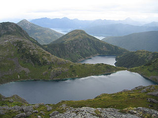
The Chugach Mountains of southern Alaska are the northernmost of the several mountain ranges that make up the Pacific Coast Ranges of the western edge of North America. The range is about 250 miles (402 km) long and 60 miles (97 km) wide, and extends from the Knik and Turnagain Arms of the Cook Inlet on the west to Bering Glacier, Tana Glacier, and the Tana River on the east. It is bounded on the north by the Matanuska, Copper, and Chitina rivers. The highest point of the Chugach Mountains is Mount Marcus Baker, at 13,094 feet (3,991 m), but with an average elevation of 4,006 feet (1,221 m), most of its summits are not especially high. Even so, its position along the Gulf of Alaska ensures more snowfall in the Chugach than anywhere else in the world, an annual average of over 1500 cm (800 in).

The Glenn Highway is a highway in the U.S. state of Alaska, extending 179 miles (288 km) from Anchorage near Merrill Field to Glennallen on the Richardson Highway. The Tok Cut-Off is often considered part of the Glenn Highway, for a total length of 328 miles (528 km).

<span class="mw-page-title-main">Anchorage School District</span> School district in Alaska

The Anchorage School District (ASD) manages all public schools within the Municipality of Anchorage in the U.S. state of Alaska. It is the 107th largest school district in the United States, serving over 45,000 students in more than 90 schools.

<span class="mw-page-title-main">Chugiak, Anchorage</span> Unincorporated community in the state of Alaska, United States

Chugiak is an unincorporated community in the Municipality of Anchorage in the U.S. state of Alaska, situated approximately 20 miles (32 km) northeast of downtown Anchorage.

<span class="mw-page-title-main">Chugach State Park</span> State park in Alaska, United States

Chugach State Park covers 495,204 acres covering a hilly region immediately east of Anchorage, in south-central Alaska.

<span class="mw-page-title-main">History of Anchorage, Alaska</span>

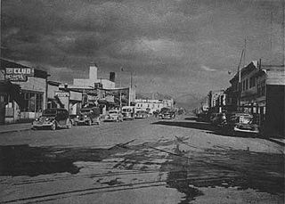
After congress approved the completion of the Alaska Railroad from Seward to Fairbanks in 1914, it was decided that a new town should be built as a port and rail hub along the route. The decision was made to develop a site near Ship Creek on Cook Inlet. Survey parties visited the area in 1914 and researched possible routes for the rails and options for siting the new town. Anchorage was originally settled as a tent city near the mouth of Ship Creek in 1915, and a planned townsite was platted alongside the bluff to the south. Anchorage was mostly a company town for the Alaska Railroad for its first several decades of existence.

<span class="mw-page-title-main">Eagle River High School</span> Public school in Eagle River, Alaska, United States

Eagle River High School (ERHS) is a public high school in Eagle River, a suburb of the city of Anchorage in the U.S. state of Alaska. Opened in 2005, it serves students living in Eagle River and on Joint Base Elmendorf-Richardson. Enrollment in the 2016-17 year is 894. The current principal is Timothy Helvey.

<span class="mw-page-title-main">Mat-Su Regional Medical Center</span> Hospital in Alaska, United States

Mat-Su Regional Medical Center is a 125-bed general hospital in the U.S. state of Alaska. The hospital is owned by Community Health Systems (CHS). Located in the Gateway census-designated place, between Palmer and Wasilla, it is the principal hospital for the Matanuska-Susitna Borough. Owing to its location a short distance from the interchange of the Glenn and Parks Highways, Mat-Su Regional serves as a principal hospital for many of the Glenn Highway communities in northern Anchorage, such as Chugiak, Eagle River, Eklutna and Peters Creek.

<span class="mw-page-title-main">Ship Creek (Alaska)</span> River in Alaska, United States

Ship Creek (Dena'ina: Dgheyaytnu) is an Alaskan river that flows from the Chugach Mountains into Cook Inlet. The Port of Anchorage at the mouth of Ship Creek gave its name to the city of Anchorage that grew up nearby.

<span class="mw-page-title-main">Anchorage, Alaska</span> Consolidated city-borough in Alaska, United States

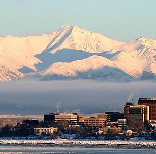
The Municipality of Anchorage is the largest city in the U.S. state of Alaska by population. With a population of 291,247 at the 2020 census, it contains nearly 40 percent of the state's population, and has more people than all of Northern Canada and Greenland combined. The Anchorage metropolitan area, which includes Anchorage and the neighboring Matanuska-Susitna Borough, had a population of 398,328 in 2020, accounting for more than half the state's population. At 1,706 sq mi (4,420 km2) of land area, the city is the fourth-largest by area in the United States and larger than the smallest state, Rhode Island, which has 1,212 sq mi (3,140 km2).

<span class="mw-page-title-main">Government Hill, Anchorage</span> United States historic place

Government Hill is a neighborhood in the northwest part of Anchorage, Alaska, sitting in between Anchorage's downtown area and the western reaches of Joint Base Elmendorf-Richardson, specifically the portion formerly known as Elmendorf Air Force Base. The neighborhood is named for the "hill" it sits on of about 115 feet (35 m) bearing the same name, which is actually a bluff which rises alongside the northern banks of Ship Creek. The origins of the name date to 1915, when a federal land reserve was created in the area for the Alaska Engineering Commission, then heavily involved in constructing the Alaska Railroad nearby.

<span class="mw-page-title-main">Randy Phillips (politician)</span> American politician

Randell Ernest "Randy" Phillips is a retired politician from the U.S. state of Alaska. Phillips served for twenty-six years as a Republican member of the Alaska House of Representatives and the Alaska Senate, from 1977 to 2003.

<span class="mw-page-title-main">Eagle River (Cook Inlet)</span> River in Alaska, United States

The Eagle River is a stream, 40 miles (64 km) long, in Anchorage, Alaska. Heading at Eagle Glacier in Chugach State Park, it flows northwest into Eagle Bay on the Knik Arm of Cook Inlet, 9 miles (14 km) northeast of downtown Anchorage.

<span class="mw-page-title-main">Tikahtnu Commons</span> Shopping mall in Alaska, United States

Tikahtnu Commons is a 900,000 square foot power center located on a 95-acre parcel in Anchorage, Alaska, United States. It is owned by Cook Inlet Region, Inc., an Alaska Native corporation and Browman Development Company, a California corporation. The shopping center consists of several large anchor stores, dozens of smaller restaurants, shops and services, and a 16-screen Regal Cinemas theater. Tikahtnu is the word for Cook Inlet in the Dena'ina language. Tikahtnu Commons is home to many firsts for Alaska, including the state's first Kohl's, PetSmart and IMAX theater. Tikahtnu Commons is the largest single-owner shopping center in the state and is even large by national comparison. The International Council of Shopping Centers states that power centers in the United States typically range from 250,000 to 600,000 square feet with an average of 420,160 square feet (39,034 m2). Construction of the center began in 2007 and by the summer of 2015, it had been developed to roughly 98% capacity. Anchors include Lowes, Old Navy, Petsmart, Kohls, Burlington, Target, Best Buy, Regal Cinemas, and Costco.

<span class="mw-page-title-main">Spring Creek Lodge</span> United States historic place

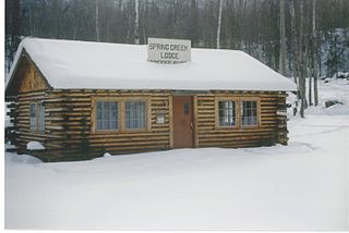
The Spring Creek Lodge is a historic former restaurant at 18389 Old Glenn Highway in the Chugiak area of Anchorage, Alaska. Vernon and Alma Haik built the Spring Creek Lodge in 1949. It served as an essential eatery and community center in southcentral Alaska from 1949 to 1974. The lodge was famous for its homemade bread and banana cream pies, and it was the place to go for a hearty Sunday dinner. For 25 years, the lodge served homesteaders, hunters from the Matanuska Valley, and military personnel from the Elmendorf Air Force Base and Fort Richardson in Anchorage. The lodge stands at Mile 20 on the two-lane Palmer Highway halfway between Palmer and Anchorage. It also served as the first community center for the early settlers of Chugiak. On September 9, 2001, the Spring Creek Lodge was inducted to the National Register of Historic Places "in recognition of its contributions to the cultural heritage of Alaska." The restaurant was a local landmark until its location was bypassed by the new Glenn Highway in 1969, after which it closed.

<span class="mw-page-title-main">Vista Peak (Alaska)</span> Mountain in Alaska

Vista Peak is a 5,019-foot (1,530 m) mountain summit in the U.S. state of Alaska.

References

  1. newsengin (2019-04-18). "EAGLEXIT: Chugiak-Eagle River residents renew separation push". The Alaska Star. Retrieved 2020-11-23.
  2. Armstrong, Amy. "Eaglexit: Some Folks in Chugiak-Eagle River Want to Leave Anchorage Behind". The Anchorage Press. Retrieved 2020-11-23.
  3. "Eaglexit backers continue to seek support". Anchorage Daily News. 2019-10-10. Retrieved 2020-11-23.
  4. "About Us," Chugiak Eagle River Chamber of Commerce official website, 2023. Retrieved Nov. 14, 2023.
  5. "Community Enjoyed Brief Independence". Echo Magazine. November 3, 2016. Retrieved September 12, 2019.[ permanent dead link ]
  6. "Commission: 44 ways to secede". Alaska Star. 2004-03-25. Archived from the original on 2011-08-07. Retrieved 2011-05-24.
  7. "Residents speak out on Eagle River's separation from Anchorage study". Alaska Star. 2007-04-19. Archived from the original on 2011-08-07. Retrieved 2011-05-24.
  8. "Chugiak-Eagle River secession movement gains support". Anchorage Daily News . 2019-05-08. Retrieved 2019-09-12.
  9. Tunseth, Matt. "Hiking Mount Baldy: Eagle River’s hometown hill," 8 July 2017, Chugiak-Eagle River Star. Retrieved 1 January 2019.
  10. Tunseth, Matt. "Hang gliders forging new paths on old homestead," 31 July 2017, Chugiak-Eagle River Star. Retrieved 1 January 2019.
  11. "www.weather.com".
  12. "Eagle RVR Gakona Circle, Alaska 1991-2020 Monthly Normals" . Retrieved August 16, 2023.
  13. "Eagle RVR NATURE CTR, Alaska 1991-2020 Monthly Normals" . Retrieved September 3, 2023.
  14. "xmACIS". National Oceanic and Atmospheric Administration. Retrieved November 7, 2023.
  15. "U.S. Decennial Census". Census.gov. Archived from the original on May 7, 2015. Retrieved June 6, 2013.
  16. Community Information Summaries: "Eagle River-Chugiak." Archived 2007-04-02 at the Wayback Machine Alaska Community Database Online, Alaska Department of Commerce, Community, and Economic Development. Retrieved on 2007-02-24.
  17. " "Chugiak-Eagle River Comprehensive Plan Update". Municipality of Anchorage. December 2006. Retrieved 2019-09-12.
  18. newsengin (2018-12-06). "Businesses struggle to reopen after earthquake rocks Eagle River". The Alaska Star. Retrieved 2020-11-23.
  19. Palsha, Rebecca. "Three weeks later, many businesses in Anchorage and Eagle River remain closed because of earthquake damage". alaskasnewssource.com. Retrieved 2020-11-23.
  20. "Gruening Middle School walk-through offers insight into post-quake rebuilding plan". Anchorage Daily News. 2019-12-24. Retrieved 2020-11-23.
  21. "Two Eagle River Schools to remain closed next school year due to Nov. 30 quake damage". Alaska Public Media. Retrieved September 12, 2019.
  22. "UAA won't renew lease on Eagle River campus". Alaska Star. Retrieved September 12, 2019.
  23. "Homepage". Alaska Star . Retrieved 2008-09-10.
  24. "Lee Brookins Jordan (1930 - 2018)Obituary". Anchorage Daily News . Retrieved 2019-09-12.
  25. "Lee Jordan, icon of Chugiak-Eagle River, dead at 88". Anchorage Daily News . 2019-01-02. Retrieved 2019-09-12.
  26. ""Binkley Co. buys three Morris publications"". Alaska Journal of Commerce. 2018-02-19. Retrieved 2019-09-12.
  27. "The ECHO". The ECHO.
  28. "Knik Arm Couriers – Chugiak-Eagle River Historical Society".

Commons-logo.svg Media related to Eagle River, Alaska at Wikimedia Commons

61°19′17″N149°34′04″W / 61.32139°N 149.56778°W / 61.32139; -149.56778