East China Sea EEZ disputes

Last updated
View of East China Sea from Yeliou, Taiwan View of South China Sea.jpg
View of East China Sea from Yeliou, Taiwan

There are disputes between China, Japan, Taiwan and South Korea over the extent of their respective exclusive economic zones (EEZs) in the East China Sea.

Contents

The dispute between the Peoples Republic of China (PRC) and Japan concerns the different application of the 1982 United Nations Convention on the Law of the Sea (UNCLOS), which both nations have ratified. [1] China proposed the application of UNCLOS, considering the natural prolongation of its continental shelf, advocating that the EEZ extends as far as the Okinawa Trough. [2] [3] Its Ministry of Foreign Affairs has stated that "the natural prolongation of the continental shelf of China in the East China Sea extends to the Okinawa Trough and beyond 200 nautical miles from the baselines from which the breadth of the territorial sea of China is measured," [2] which is applicable to the relevant UNCLOS provisions that support China's right to the natural shelf. [2] [3]

In 2012, China presented a submission under the UNCLOS concerning the outer limits of the continental shelf to the UN. [4] Japan, based on UNCLOS, proposed the Median line division of the EEZ. [5]

Under the United Nations' Law of the Sea, the PRC claims the disputed ocean territory as its own Exclusive Economic Zone (EEZ) due to its being part of PRC's natural extension of its continental shelf, while Japan claims the disputed ocean territory as its own EEZ because it is within 200 nautical miles (370 km) from Japan's coast, and proposed a median line as the boundary between the EEZ of China and Japan. About 40,000 square kilometres (15,000 square miles) of EEZ are in dispute. China and Japan both claim 200 nautical miles (370 km; 230 mi) of EEZ rights, but the East China Sea width is only 360 nautical miles (670 km; 410 mi). China claims an EEZ extending to the eastern end of the Chinese continental shelf (based on UNCLOS III) which goes deep into the Japanese's claimed EEZ. [6]

Location of the confirmed gas fields (red dots) near the Median Line between China and Japan: Chun Xiao (Chunxiao) / Bai Hua (Shirakaba), Duan Qiao (Duanqiao) / Nan (Kusu), Leng Quan (Lengquan) / Jie Geng (Kikyo), Tian Wai Tian (Tianwaitian) / Jian (Kashi), Long Jing (Longjing) / Yi Kuai (Asunaro) East China sea digging map.svg
Location of the confirmed gas fields (red dots) near the Median Line between China and Japan: 春暁(Chunxiao) / 白樺(Shirakaba), 断橋(Duanqiao) / 楠(Kusu), 冷泉(Lengquan) / 桔梗(Kikyo), 天外天(Tianwaitian) / 樫(Kashi), 龍井(Longjing) / 翌檜(Asunaro)

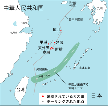
In 1995, the People's Republic of China (PRC) discovered an undersea natural gas field in the East China Sea, namely the Chunxiao gas field, [7] which lies within the Chinese EEZ while Japan believes it is connected to other possible reserves beyond the median line. [8] Japan has objected to PRC development of natural gas resources in the East China Sea near an area where the two countries Exclusive Economic Zone (EEZ) claims overlap. The specific development in dispute is the PRC's drilling in the Chunxiao gas field, which is located in undisputed areas on China's side, three or four miles (6 km) west of the median line proposed by Japan. Japan maintains that although the Chunxiao gas field rigs are on the PRC side of a median line that Tokyo regards as the two sides' sea boundary, they may tap into a field that stretches underground into the disputed area. [9] Japan therefore seeks a share in the natural gas resources. The gas fields in the Xihu Sag area in the East China Sea (Canxue, Baoyunting, Chunxiao, Duanqiao, Wuyunting, and Tianwaitian) are estimated to hold proven reserves of 364 BCF of natural gas. Commercial operations began 2006. In June 2008, both sides agreed to jointly develop the Chunxiao gas fields. [9] [10]

Rounds of disputes about island ownership in the East China Sea have triggered both official and civilian protests between China and Japan. [11]

The dispute between PRC and South Korea concerns Socotra Rock, a submerged reef on which South Korea has constructed a scientific research station. While neither country claims the rock as territory, the PRC has objected to Korean activities there as a breach of its EEZ rights. [12]

South Korea opened a museum in central Seoul in 2012 to back its claim to the Liancourt Rocks. Visitors can walk around a large 3-D model of the island and examine video and computerized content on the island's history and nature. Video screens show live footage of the island from a fixed camera. In January 2018 the Japanese government opened a small museum in Tokyo displaying maps and documents to defend its territorial claims against neighboring South Korea and China. [13]

See also

Related Research Articles

<span class="mw-page-title-main">United Nations Convention on the Law of the Sea</span> International maritime law

The United Nations Convention on the Law of the Sea (UNCLOS), also called the Law of the Sea Convention or the Law of the Sea Treaty, is an international agreement that establishes a legal framework for all marine and maritime activities. As of May 2023, 168 countries and the European Union are parties.

<span class="mw-page-title-main">East China Sea</span> Marginal sea of the Pacific Ocean

The East China Sea is a marginal sea of the Western Pacific Ocean, located directly offshore from East China. China names the body of water along its eastern coast as "East Sea" due to direction, the name of "East China Sea" is otherwise designated as formal name by International Hydrographic Organization(IHO) and used internationally.

<span class="mw-page-title-main">Artificial island</span> Island constructed by people

An artificial island is an island that has been constructed by humans rather than formed through natural processes. Other definitions may suggest that artificial islands are lands with the characteristics of human intervention in their format process, while others argue that artificial islands are created by expanding existing islets, constructing on existing reefs, or amalgamating several islets together. Although constructing artificial islands is not a modern phenomenon, there is no definite legal definition of it. Artificial islands may vary in size from small islets reclaimed solely to support a single pillar of a building or structure to those that support entire communities and cities. Archaeologists argue that such islands were created as far back as the Neolithic era. Early artificial islands included floating structures in still waters or wooden or megalithic structures erected in shallow waters.

<span class="mw-page-title-main">Territorial waters</span> Coastal waters that are part of a sovereign states sovereign territory

Territorial waters are informally an area of water where a sovereign state has jurisdiction, including internal waters, the territorial sea, the contiguous zone, the exclusive economic zone, and potentially the extended continental shelf. In a narrower sense, the term is often used as a synonym for the territorial sea.

<span class="mw-page-title-main">Exclusive economic zone</span> Adjacent sea zone in which a state has special rights

An exclusive economic zone (EEZ), as prescribed by the 1982 United Nations Convention on the Law of the Sea, is an area of the sea in which a sovereign state has exclusive rights regarding the exploration and use of marine resources, including energy production from water and wind. EEZ does not define the ownership of any maritime features within the EEZ.

<span class="mw-page-title-main">Chunxiao gas field</span>

The Chunxiao gas field is a natural gas field below the East China Sea within the Chinese Exclusive Economic Zone, about 4 km to the west of the EEZ border claimed by Japan which is disputed by China. The Chunxiao gas field is the first of a group of four natural gas fields in the Xihu Trough being developed by China: the other ones are Tianwaitian, Duanqiao, and Canxue.

James Shoal is a reef (bank) in the South China Sea, with a depth of 22 metres (72 ft) below the surface of the sea, located about 45 nautical miles off the Borneo coast of Malaysia. It is claimed by Malaysia, the People's Republic of China, and the Republic of China (Taiwan). The reef and its surrounds are administered by Malaysia.

Ambalat is a sea block in the Celebes sea located off the east coast of Borneo. It lies to the east of the Indonesian province of North Kalimantan and to the south-east of the Malaysian state of Sabah, and it is the subject of a territorial dispute between the two nations. Malaysia refers to part of the Ambalat block as Block ND6 (formerly Block Y) and part of East Ambalat Block as Block ND7 (formerly Block Z). The deep sea blocks contain an estimated 62,000,000 barrels (9,900,000 m3) of oil and 348 million cubic meters of natural gas. Other estimates place it substantially higher: 764,000,000 barrels (121,500,000 m3) of oil and 3.96 × 10¹⁰ cubic meters (1.4 trillion cubic feet) of gas, in only one of nine points in Ambalat.

<span class="mw-page-title-main">Territorial claims in the Arctic</span>

The Arctic consists of land, internal waters, territorial seas, exclusive economic zones (EEZs) and international waters above the Arctic Circle. All land, internal waters, territorial seas and EEZs in the Arctic are under the jurisdiction of one of the eight Arctic coastal states: Canada, Denmark, Finland, Iceland, Norway, Russia, Sweden and the United States. International law regulates this area as with other portions of Earth.

<span class="mw-page-title-main">Subi Reef</span> Disputed reef in the Spratly Islands

Subi Reef, also known as Zamora Reef ; Zhubi Reef ; Vietnamese: đá Xu Bi, is an atoll in the Spratly Islands of the South China Sea located 26 km (16 mi) southwest of Philippines' Pag-asa island Thitu Island under the municipality of the Kalayaan Island Group, Palawan province as claimed by Philippines. It is occupied by China (PRC), and claimed by Taiwan (ROC) and Vietnam. According to the claims of the PRC, it currently falls under the de facto jurisdiction of Nansha islands, Sansha city, Hainan province, China. But under the clauses of the UNCLOS, which the PRC is also a signatory, the international law only the Philippines has the maritime rights to exploit its resources or build structures, as it is within the continental shelf of the coastal country.

<span class="mw-page-title-main">Spratly Islands dispute</span> Territorial dispute between China and Southeast Asian countries.

The Spratly Islands dispute is an ongoing territorial dispute between Brunei, China, Malaysia, the Philippines, Taiwan, and Vietnam concerning "ownership" of the Spratly Islands, a group of islands and associated "maritime features" located in the South China Sea. The dispute is characterized by diplomatic stalemate and the employment of military pressure techniques in the advancement of national territorial claims. All except Brunei occupy some of the maritime features.

<span class="mw-page-title-main">Territorial disputes in the South China Sea</span> Disputes over ownership of islands in the South China Sea

Territorial disputes in the South China Sea involve conflicting island and maritime claims in the South China Sea by several sovereign states, namely the People's Republic of China (PRC), Taiwan, Brunei, Malaysia, the Philippines, and Vietnam. The disputes involve the islands, reefs, banks, and other features of the region, including the Spratly Islands, Paracel Islands, Scarborough Shoal, and various boundaries in the Gulf of Tonkin. The waters near the Indonesian Natuna Islands, which some regard as geographically part of the South China Sea, are disputed as well. Maritime disputes also extend beyond the South China Sea, as in the case of the Senkaku Islands and the Socotra Rock, which lie in the East China Sea.

<span class="mw-page-title-main">Cyprus–Turkey maritime zones dispute</span> Ongoing political dispute in the Mediterranean

The Republic of Cyprus (Cyprus) and Turkey have been engaged in a dispute over the extent of their exclusive economic zones (EEZ), ostensibly sparked by oil and gas exploration in the area. Turkey objects to Cypriot drilling in waters that Cyprus has asserted a claim to under international maritime law. The present maritime zones dispute touches on the perennial Cyprus and Aegean disputes; Turkey is the only member state of the United Nations that does not recognise Cyprus, and is one of the few not signatory to the United Nations Convention on the Law of the Sea, which Cyprus has signed and ratified.

<span class="mw-page-title-main">Rockall Bank dispute</span> Conflicting maritime claims

Several states have claimed interests over the sea bed adjoining Rockall, an uninhabitable granite islet which is located within the exclusive economic zone (EEZ) of the United Kingdom. Ireland, Denmark, Iceland, and the United Kingdom have all made submissions to the commission set up under the United Nations Convention on the Law of the Sea (UNCLOS).

<span class="mw-page-title-main">Exclusive economic zone of Japan</span> Economic zone exclusive to Japan

Japan has the eighth-largest exclusive economic zone (EEZ) in the world. The total area of Japan is about 380 thousand km2. Japan's EEZ area is vast and the territorial waters and EEZ together is about 4.47 million km2.

<span class="mw-page-title-main">Exclusive economic zone of North Korea</span> North Korean maritime boundary

The exclusive economic zone of North Korea stretches 200 nautical miles from its basepoints in both the Yellow Sea and the Sea of Japan. The exclusive economic zone (EEZ) was declared in 1977 after North Korea had contested the validity of the Northern Limit Lines (NLL) set up after the Korean War as maritime borders. The EEZ has not been codified in law and North Korea has never specified its coordinates, making it difficult to determine its specific scope.

<span class="mw-page-title-main">Exclusive economic zone of Vietnam</span> Economic zone exclusive to Vietnam

Vietnam claims an exclusive economic zone (EEZ) of 1,395,096 km2 (538,650 sq mi) with 200 nautical miles from its shores.

<span class="mw-page-title-main">Exclusive economic zone of India</span> Economic zone exclusive to India

India has the 18th-largest exclusive economic zone (EEZ) with a total size of 2,305,143 km2 (890,021 sq mi). It includes the Lakshadweep island group in the Laccadive Sea off the southwestern coast of India and the Andaman and Nicobar Islands in the Bay of Bengal and the Andaman Sea. India's EEZ is bordered to the west by Pakistan, to the south by the Maldives and Sri Lanka and to the east by Bangladesh, Myanmar, Thailand, Malaysia and Indonesia. Based on new scientific data, India has petitioned United Nations to extend its EEZ from 200 Nautical miles to 500 miles.

Greece has claimed an Exclusive Economic Zone (EEZ) as per UNCLOS 1982 as well as customary international law. The total size is 505,572 km2 (195,202 sq mi) which is the 53rd largest in the world.

<span class="mw-page-title-main">Japan–Korea Joint Development Zone</span> Oil-rich area in the East China Sea

The Japan–Korea Joint Development Zone, often abbreviated as the JDZ, is an area in the East China Sea jointly administered by Japan and the Republic of Korea since 1978. The area was first defined by the continental shelf in the waters south of Jeju Island, west of Kyushu, and north of Okinawa.

References

  1. Koo, Min Gyo (2009). Island Disputes and Maritime Regime Building in East Asia. Springer. pp. 182–183. ISBN   9781441962232.
  2. 1 2 3 Wang, Yuanyuan (2012). "China to submit outer limits of continental shelf in East China Sea to UN". Xinhua. Archived from the original on November 5, 2012.
  3. 1 2 Guo, Rongxing (2006). Territorial Disputes and Resource Management: A Global Handbook. New York: Nova Science Publishers, Inc. p. 104. ISBN   9781600214455.
  4. Yu, Runze (2012-12-15). "China reports to UN outer limits of continental shelf in E. China Sea". SINA English. Archived from the original on November 14, 2013.
  5. "Diplomatic Bluebook 2006" (PDF). Ministry of Foreign Affairs of Japan. p. 43. Archived from the original (PDF) on 2013-12-08.
  6. Pike, John. "Senkaku/Diaoyutai Islands". Globalsecurity.org. Archived from the original on 2004-11-17.
  7. Kim, Sun Pyo (2004). Maritime Delimitation and Interim Arrangements in North East Asia. The Hague: Martinus Nijhoff Publishers. p. 285. ISBN   9789004136694.
  8. Bush, Richard C. (2010). The Perils of Proximity: China-Japan Security Relations. Washington, D.C.: Brookings Institution Press. p. 76. ISBN   9780815704744.
  9. 1 2 Fackler, Martin (19 June 2008). "China and Japan in Deal Over Contested Gas Fields". The New York Times. Archived from the original on 8 December 2013.
  10. Ersan, Yagmur (2013-07-25). "China, Japan conflict on Chunxiao/Shirakaba gas field". The Journal of Turkish Weekly. Archived from the original on January 25, 2014. Retrieved 2013-12-08.
  11. "Chinese, Japanese Stage Protests Over East China Sea Islands". Voice of America. 2008-10-15. Archived from the original on October 14, 2012.
  12. You, Ki-Jun (19 March 2012). "Marine Scientific Research in Northeast Asia". In Nordquist, Myron H.; Moore, John Norton; Soons, Alfred H. A.; et al. (eds.). The Law of the Sea Conventions: US Accession and Globalization. Martinus Nijhoff Publishers. p. 499. ISBN   978-90-04-20136-1.
  13. "Museum opens in Tokyo, displaying documents to defend claims to disputed isles". Japan Today. Retrieved 2018-11-20.

Further reading