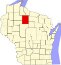
Elk, Wisconsin

Last updated

Elk, Wisconsin
WIMap-doton-Elk.png
Location of Elk, Wisconsin
Coordinates: 45°41′55″N90°31′0″W / 45.69861°N 90.51667°W / 45.69861; -90.51667
Country Flag of the United States.svg  United States
State Flag of Wisconsin.svg  Wisconsin
County Price
Area
  Total53.6 sq mi (138.7 km2)
  Land50.8 sq mi (131.6 km2)
  Water2.7 sq mi (7.1 km2)
Elevation
[1]
1,437 ft (438 m)
Population
 (2000)
  Total1,183
  Density23.3/sq mi (9.0/km2)
Time zone UTC-6 (Central (CST))
  Summer (DST) UTC-5 (CDT)
Area code(s) 715 & 534
FIPS code 55-23200 [2]
GNIS feature ID1583147 [1]

Elk is a town in Price County, Wisconsin, United States. The population was 1,183 at the 2000 census.

Contents

Geography

According to the United States Census Bureau (USCB), the town has a total area of 53.5 square miles (138.7 km2), of which, 50.8 square miles (131.6 km2) is land and 2.7 square miles (7.1 km2) (5.10%) is water.

Demographics

As of the census [2] of 2000, there were 1,183 people, 502 households, and 365 families residing in the town. The population density was 23.3 people per square mile (9.0/km2). There were 933 housing units at an average density of 18.4 per square mile (7.1/km2). The racial makeup of the town was 98.73% White, 0.51% Native American, 0.08% from other races, and 0.68% from two or more races. Hispanic or Latino people of any race were 0.59% of the population.

There were 502 households, out of which 27.7% had children under the age of 18 living with them, 66.9% were married couples living together, 5.4% had a female householder with no husband present, and 27.1% were non-families. 23.3% of all households were made up of individuals, and 11.4% had someone living alone who was 65 years of age or older. The average household size was 2.36 and the average family size was 2.78.

In the town, the population was spread out, with 21.5% under the age of 18, 5.4% from 18 to 24, 24.3% from 25 to 44, 30.2% from 45 to 64, and 18.6% who were 65 years of age or older. The median age was 44 years. For every 100 females, there were 98.5 males. For every 100 females age 18 and over, there were 96.8 males.

The median income for a household in the town was $41,953, and the median income for a family was $50,769. Males had a median income of $37,266 versus $21,607 for females. The per capita income for the town was $22,310. About 3.4% of families and 5.7% of the population were below the poverty line, including 2.7% of those under age 18 and 9.3% of those age 65 or over.

Notable people

Related Research Articles

<span class="mw-page-title-main">Bellemeade, Kentucky</span> City in Kentucky, United States

Bellemeade is a home rule-class city in Jefferson County, Kentucky, United States. It was formally incorporated by the state assembly in 1956. The population was 909 at the 2020 census.

<span class="mw-page-title-main">Burnham, Maine</span> Town in the state of Maine, United States

Burnham is a town in Waldo County, Maine, United States. The population was 1,096 at the 2020 census.

<span class="mw-page-title-main">Charlestown, Maryland</span> Town in Maryland, United States

Charlestown is a town in Cecil County, Maryland, United States. The population was 1,183 at the 2010 census.

<span class="mw-page-title-main">Goodman, Missouri</span> City in Missouri, United States

Goodman is a city in McDonald County, Missouri, United States. The population was 1,202 at the 2020 census.

<span class="mw-page-title-main">Bayboro, North Carolina</span> Town in North Carolina, United States

Bayboro is a town in Pamlico County, North Carolina, United States. The population was 1,161 at the 2020 U.S. census. It is the county seat of Pamlico County.

<span class="mw-page-title-main">Lithopolis, Ohio</span> Village in Ohio, United States

Lithopolis is a village in Fairfield and Franklin counties in the U.S. state of Ohio. The population was 2,134 at the 2020 census.

<span class="mw-page-title-main">Rushville, Ohio</span> Village in Ohio, United States

Rushville is a village in Fairfield County, Ohio, United States. The population was 304 at the 2020 census. Much of the village is listed on the National Register of Historic Places as the Rushville Historic District.

<span class="mw-page-title-main">Mercer Township, Pennsylvania</span> Township in Pennsylvania, United States

Mercer Township is a township in Butler County, Pennsylvania, United States. The population was 1,010 at the 2020 census.

<span class="mw-page-title-main">Green Township, Forest County, Pennsylvania</span> Township in Pennsylvania, United States

Green Township is a township in Forest County, Pennsylvania, United States. The population was 371 at the 2020 census, down from 522 in 2010, which was, in turn, an increase from 397 in 2000.

<span class="mw-page-title-main">West Wyoming, Pennsylvania</span> Borough in Pennsylvania, United States

West Wyoming is a borough that is located in Luzerne County, Pennsylvania, United States. The borough is part of the Greater Pittston metro area.

<span class="mw-page-title-main">Burnettown, South Carolina</span> Town in South Carolina, United States of America

Burnettown is a town in Aiken County, South Carolina, United States. The population was 3,105 at the 2020 census. It is part of the Augusta, Georgia metropolitan area. Burnettown is located in historic Horse Creek Valley.

<span class="mw-page-title-main">Granger, Texas</span> City in Texas, United States

Granger is a city in Williamson County, Texas, United States. It was incorporated in 1891. The population was 1,183 at the 2020 census.

<span class="mw-page-title-main">Keller, Virginia</span> Town in Virginia, United States

Keller is a town in Accomack County, Virginia, United States. The population was 178 at the 2010 census.

<span class="mw-page-title-main">Strongs Prairie, Wisconsin</span> Town in Wisconsin, United States

The Town of Strongs Prairie is located in Adams County in the U.S. state of Wisconsin. The population was 1,150 at the 2010 census. The unincorporated communities of Arkdale, Dellwood, and Strongs Prairie are located within the town.

<span class="mw-page-title-main">Frankfort, Pepin County, Wisconsin</span> Town in Wisconsin, United States

Frankfort is a town in Pepin County, Wisconsin, United States. The population was 325 at the 2020 census. The unincorporated communities of Ella, and Porcupine are located in the town.

<span class="mw-page-title-main">Phillips, Wisconsin</span> City in Wisconsin, United States

Phillips is a city and the county seat of Price County, Wisconsin, United States. The population was 1,478 at the 2010 census.

<span class="mw-page-title-main">Mineral Ridge, Ohio</span> Census-designated place in Ohio, United States

Mineral Ridge is an unincorporated community and census-designated place in southern Trumbull and northern Mahoning counties in the U.S. state of Ohio. The population was 3,951 at the 2020 census. It is a suburb of the Youngstown–Warren metropolitan area. Mineral Ridge was named for valuable coal deposits near the original town site.

<span class="mw-page-title-main">Paden City, West Virginia</span> City in West Virginia, United States

Paden City is a city in Tyler and Wetzel counties in the U.S. state of West Virginia, along the Ohio River. It was founded in 1902. The population was 2,550 at the 2020 census.

<span class="mw-page-title-main">Hazel Green, Wisconsin</span> Village in Wisconsin, United States

Hazel Green is a village in Grant and Lafayette counties in the U.S. state of Wisconsin. The population was 1,256 at the 2010 census. Of this, 1,243 were in Grant County, and only 13 were in Lafayette County. The village is located mostly within the Town of Hazel Green in Grant County; only a small portion extends into the Town of Benton in Lafayette County.

<span class="mw-page-title-main">England, Arkansas</span> City in Arkansas, United States

England is a city in southwestern Lonoke County, Arkansas, United States and the county's fourth most populous city. The population was 2,825 at the 2010 census. It is part of the Little Rock–North Little Rock–Conway Metropolitan Statistical Area.

References

  1. 1 2 "US Board on Geographic Names". United States Geological Survey. October 25, 2007. Retrieved January 31, 2008.
  2. 1 2 "U.S. Census website". United States Census Bureau . Retrieved January 31, 2008.
  3. 'Wisconsin Blue Book 1954,' Biographical Sketch of Willis J. Hutnik, pg. 62