Worcester, Wisconsin

Last updated

Worcester, Wisconsin
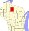
WIMap-doton-Worcester.png
Location of Worcester, Wisconsin
Coordinates: 45°43′55″N90°20′2″W / 45.73194°N 90.33389°W / 45.73194; -90.33389
Country Flag of the United States.svg  United States
State Flag of Wisconsin.svg  Wisconsin
County Price
Area
  Total121.0 sq mi (313.4 km2)
  Land117.3 sq mi (303.8 km2)
  Water3.7 sq mi (9.6 km2)
Elevation
[1]
1,483 ft (452 m)
Population
 (2000)
  Total1,711
  Density14.6/sq mi (5.6/km2)
Time zone UTC-6 (Central (CST))
  Summer (DST) UTC-5 (CDT)
Area code(s) 715 & 534
FIPS code 55-89100 [2]
GNIS feature ID1584482 [1]

Worcester is a town in Price County, Wisconsin, United States. The population was 1,711 at the 2000 census. The unincorporated community of Cranberry Lake is located in the town.

Contents

Geography

According to the United States Census Bureau, the town has a total area of 121.0 square miles (313.4 km2), of which, 117.3 square miles (303.8 km2) is land and 3.7 square miles (9.6 km2) (3.06%) is water.

Demographics

As of the census [2] of 2000, there were 1,711 people, 699 households, and 499 families residing in the town. The population density was 14.6 people per square mile (5.6/km2). There were 1,220 housing units at an average density of 10.4 per square mile (4.0/km2). The racial makeup of the town was 98.60% White, 0.06% African American, 0.64% Native American, 0.06% Asian, 0.23% from other races, and 0.41% from two or more races. Hispanic or Latino people of any race were 0.88% of the population.

There were 699 households, out of which 30.5% had children under the age of 18 living with them, 62.5% were married couples living together, 5.0% had a female householder with no husband present, and 28.5% were non-families. 24.9% of all households were made up of individuals, and 10.7% had someone living alone who was 65 years of age or older. The average household size was 2.45 and the average family size was 2.94.

In the town, the population was spread out, with 24.8% under the age of 18, 4.6% from 18 to 24, 28.6% from 25 to 44, 25.0% from 45 to 64, and 16.9% who were 65 years of age or older. The median age was 40 years. For every 100 females, there were 110.7 males. For every 100 females age 18 and over, there were 108.6 males.

The median income for a household in the town was $38,750, and the median income for a family was $43,833. Males had a median income of $32,454 versus $21,064 for females. The per capita income for the town was $17,982. About 2.8% of families and 4.3% of the population were below the poverty line, including 3.7% of those under age 18 and 8.1% of those age 65 or over.

Related Research Articles

<span class="mw-page-title-main">Taylor, Alabama</span> Town in Alabama, United States

Taylor is a town in Geneva and Houston counties in the U.S. state of Alabama. Taylor was first settled in the 1870s, named after an early family that helped secure the first post office. It was not incorporated until almost a century later in June 1967. It is part of the Dothan, Alabama Metropolitan Statistical Area. At the 2010 census the population was 2,375, up from 1,898 in 2000.

<span class="mw-page-title-main">Greendale, Indiana</span> City in Indiana, United States

Greendale is a city in Dearborn County, Indiana, United States. The population was 4,602 at the 2020 census, up 82 since the 2010 Census.

<span class="mw-page-title-main">Spring Lake, Indiana</span> Town in Indiana, United States

Spring Lake is a town in Sugar Creek Township, Hancock County, Indiana, United States, along Sugar Creek. The population was 218 at the 2010 census.

<span class="mw-page-title-main">Rosedale, Indiana</span> Town in Indiana, United States

Rosedale is a town in Florida Township, Parke County, in the U.S. state of Indiana. The population was 725 at the 2010 census.

<span class="mw-page-title-main">Washburn, Maine</span> Town in the state of Maine, United States

Washburn is a town in Aroostook County, Maine, United States. It was incorporated on February 25, 1861, and named after Israel Washburn, the governor of Maine at the time. The population was 1,527 at the 2020 census. Benjamin C. Wilder House, which was built in 1852, is located on Main Street in Washburn and predates the town's incorporation by nine years.

Martiny Township is a civil township of Mecosta County in the U.S. state of Michigan. The population was 1,594 at the 2020 census.

Dell Grove Township is a township in Pine County, Minnesota, United States. The population was 699 at the 2000 census.

<span class="mw-page-title-main">Weatherby Lake, Missouri</span> City in Missouri, United States

Weatherby Lake is a city in Platte County, Missouri and is part of the Kansas City metropolitan area within the United States, which borders Kansas City. The population was 1,723 as of the 2010 census.

McCord is a census-designated place (CDP) in Osage County, Oklahoma, United States. The population was 1,440 at the 2010 census, a decrease of 15.8 percent from the figure of 1,711 reported in 2000.

<span class="mw-page-title-main">Elgin, Oregon</span> City in Oregon, United States

Elgin is a city in Union County, Oregon, United States. The population was 1,711 at the 2010 census. The community is named after the Lady Elgin, a ship lost on Lake Michigan.

<span class="mw-page-title-main">Jefferson Township, Mercer County, Pennsylvania</span> Township in Pennsylvania, United States

Jefferson Township is a township in Mercer County, Pennsylvania, United States. The population was 1,920 at the 2020 census, an increase from 1,880 in 2010.

<span class="mw-page-title-main">Parkston, South Dakota</span> City in South Dakota, United States

Parkston is a city in Hutchinson County, South Dakota, United States. The population was 1,567 at the 2020 census.

<span class="mw-page-title-main">Chesapeake, West Virginia</span> Town in West Virginia, United States

Chesapeake is a town in Kanawha County, West Virginia, United States. The population was 1,336 at the 2020 census. The town is situated on the Kanawha River.

<span class="mw-page-title-main">Ringle, Wisconsin</span> Town in Wisconsin, United States

Ringle is a town in Marathon County, Wisconsin, United States. It is part of the Wausau (WI) Metropolitan Statistical Area. The population was 1,711 at the 2010 census. The unincorporated community of Ringle is located in the town.

<span class="mw-page-title-main">Okauchee Lake, Wisconsin</span> CDP in Wisconsin, United States

Okauchee Lake is a census-designated place (CDP) in Waukesha County, Wisconsin, United States. The population was 5,094 at the 2020 census. Okauchee Lake is located in the town of Oconomowoc.

<span class="mw-page-title-main">Rittman, Ohio</span> City in Ohio, United States

Rittman is a city in Medina and Wayne counties in the U.S. state of Ohio. All but a small portion of the city is in Wayne County, within commuting distance of Akron, Canton and Cleveland. The population was 6,131 at the 2020 census.

<span class="mw-page-title-main">Viola, Wisconsin</span> Village in Wisconsin, United States

Viola is a village in Richland (mostly) and Vernon counties in the U.S. state of Wisconsin. The population was 699 at the 2010 census. Of this, 477 were in Richland County, and 222 were in Vernon County.

<span class="mw-page-title-main">Randolph (town), Wisconsin</span> Town in Wisconsin, United States

Randolph is a town in Columbia County, Wisconsin, United States. The population was 699 at the 2000 census. The Village of Randolph lies to the southeast of the town and only a tiny portion of the village is within the town. The unincorporated community of East Friesland is located in the town. The unincorporated community of Ingle is also located partially in the town.

<span class="mw-page-title-main">Montello (town), Wisconsin</span> Town in Wisconsin, United States

Montello is a town in Marquette County, Wisconsin, United States. The population was 1,043 at the 2000 census. The City of Montello and the unincorporated community of Glen Oak are located within the town.

Plover is a town in Portage County, Wisconsin, United States. As of December 2020 the town reported on its website a population of 1,731.

References

  1. 1 2 "US Board on Geographic Names". United States Geological Survey. October 25, 2007. Retrieved January 31, 2008.
  2. 1 2 "U.S. Census website". United States Census Bureau . Retrieved January 31, 2008.