Kennan, Wisconsin

Last updated

Kennan, Wisconsin
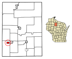
Price County Wisconsin Incorporated and Unincorporated areas Kennan Highlighted.svg
Location of Kennan in Price County, Wisconsin.
Coordinates: 45°27′35″N90°36′38″W / 45.45972°N 90.61056°W / 45.45972; -90.61056
Country Flag of the United States.svg  United States
State Flag of Wisconsin.svg  Wisconsin
County Price
Government
[1]
  Village PresidentJill Arndt
Area
[2]
  Total1.98 sq mi (5.14 km2)
  Land1.98 sq mi (5.14 km2)
  Water0.00 sq mi (0.00 km2)
Elevation
[3]
1,332 ft (406 m)
Population
 (2010) [4]
  Total135
  Estimate 
(2019) [5]
120
  Density60.48/sq mi (23.36/km2)
Time zone UTC-6 (Central (CST))
  Summer (DST) UTC-5 (CDT)
Area code(s) 715 & 534
FIPS code 55-39200 [6]
GNIS feature ID1567405 [3]

Kennan is a village in Price County, Wisconsin, United States. The population was 135 at the 2010 census. The village is located within the Town of Kennan.

Contents

Geography

Kennan is located at 45°31′50″N90°35′17″W / 45.53056°N 90.58806°W / 45.53056; -90.58806 (45.53067, -90.588056). [7]

According to the United States Census Bureau, the village has a total area of 1.99 square miles (5.15 km2), all of it land. [8]

Demographics

Historical population
CensusPop.Note
1910 184
1920 31973.4%
1930 194−39.2%
1940 25632.0%
1950 194−24.2%
1960 162−16.5%
1970 1673.1%
1980 19416.2%
1990 169−12.9%
2000 1711.2%
2010 135−21.1%
2019 (est.)120 [5] −11.1%
U.S. Decennial Census [9]

2010 census

As of the census [4] of 2010, there were 135 people, 61 households, and 44 families living in the village. The population density was 67.8 inhabitants per square mile (26.2/km2). There were 81 housing units at an average density of 40.7 per square mile (15.7/km2). The racial makeup of the village was 100.0% White. Hispanic or Latino of any race were 0.7% of the population.

There were 61 households, of which 16.4% had children under the age of 18 living with them, 54.1% were married couples living together, 8.2% had a female householder with no husband present, 9.8% had a male householder with no wife present, and 27.9% were non-families. 26.2% of all households were made up of individuals, and 13.1% had someone living alone who was 65 years of age or older. The average household size was 2.21 and the average family size was 2.64.

The median age in the village was 51.5 years. 14.1% of residents were under the age of 18; 8.1% were between the ages of 18 and 24; 18.5% were from 25 to 44; 37.8% were from 45 to 64; and 21.5% were 65 years of age or older. The gender makeup of the village was 50.4% male and 49.6% female.

2000 census

As of the census [6] of 2000, there were 171 people, 67 households, and 54 families living in the village. The population density was 86.7 people per square mile (33.5/km2). There were 75 housing units at an average density of 38.0 per square mile (14.7/km2). The racial makeup of the village was 100.00% White. 1.75% of the population were Hispanic or Latino of any race.

There were 67 households, out of which 31.3% had children under the age of 18 living with them, 64.2% were married couples living together, 7.5% had a female householder with no husband present, and 19.4% were non-families. 19.4% of all households were made up of individuals, and 9.0% had someone living alone who was 65 years of age or older. The average household size was 2.55 and the average family size was 2.93.

In the village, the population was spread out, with 24.0% under the age of 18, 7.0% from 18 to 24, 26.9% from 25 to 44, 25.1% from 45 to 64, and 17.0% who were 65 years of age or older. The median age was 38 years. For every 100 females, there were 111.1 males. For every 100 females age 18 and over, there were 124.1 males.

The median income for a household in the village was $41,786, and the median income for a family was $44,250. Males had a median income of $26,250 versus $23,000 for females. The per capita income for the village was $18,701. About 5.4% of families and 8.0% of the population were below the poverty line, including 16.7% of those under the age of eighteen and none of those 65 or over.
Related Research Articles

Pope-Vannoy Landing is a census-designated place (CDP) in the Lake and Peninsula Borough in the U.S. state of Alaska. The population was six at the 2020 census, same amount as in 2010.

<span class="mw-page-title-main">Williamson, Arizona</span> CDP in Yavapai County, Arizona

Williamson is a census-designated place (CDP) in Yavapai County, Arizona, United States. The population was 3,776 at the 2000 census and 6,196 at the 2020 census. The name "Wiliamson" is a misnomer, perhaps propagated by federal bureaucratic error; the area has long been known as "Williamson Valley" after the major road through the area, Williamson Valley Road.

<span class="mw-page-title-main">Ellenton, Georgia</span> Town in Georgia, United States

Ellenton is a town in Colquitt County, Georgia, United States. Its population was 281 at the 2010 census. It was incorporated in 1970 by the Georgia General Assembly. It is located at 31°10′36″N83°35′17″W.

<span class="mw-page-title-main">Manson, Iowa</span> City in Iowa, United States

Manson is a city in Calhoun County, Iowa, United States. The population was 1,709 at the time of the 2020 census.

<span class="mw-page-title-main">Parkway, Missouri</span> Village in Missouri, United States

Parkway is a village in Franklin County, Missouri, United States. The population was 439 at the 2010 census.

<span class="mw-page-title-main">Inman, Nebraska</span> Village in Nebraska, United States

Inman is a village in Holt County, Nebraska, United States. The population was 129 as of the 2010 census.

<span class="mw-page-title-main">Champ, Missouri</span> Village in Missouri, United States

Champ is a village in St. Louis County, Missouri, United States. The population was 10 at the 2020 census.

<span class="mw-page-title-main">East Atlantic Beach, New York</span> Hamlet and census-designated place in New York, United States

East Atlantic Beach is a hamlet and census-designated place (CDP) in Nassau County, New York, United States. The population was 2,049 at the 2010 census. The unincorporated hamlet is governed by the Town of Hempstead, one of three towns in Nassau County.

<span class="mw-page-title-main">North Randall, Ohio</span> Village in Ohio, United States

North Randall is a village in Cuyahoga County, Ohio, United States. The population was 954 at the 2020 census.

<span class="mw-page-title-main">Willoughby Hills, Ohio</span> City in Ohio, United States

Willoughby Hills is a city in Lake County, Ohio, United States, along the Chagrin River. The population was 10,019 at the 2020 census. A suburb of Cleveland, it is part of the Cleveland metropolitan area.

<span class="mw-page-title-main">Rocky Ridge, Ohio</span> Village in Ohio, United States

Rocky Ridge is a village in Ottawa County, Ohio, United States. The population was 417 at the 2010 census.

<span class="mw-page-title-main">Clearview, West Virginia</span> Village in West Virginia, United States

Clearview is a village in Ohio County, West Virginia, United States. It is part of the Wheeling, West Virginia Metropolitan Statistical Area. The population was 565 at the 2010 census.

<span class="mw-page-title-main">Steuben, Wisconsin</span> Village in Wisconsin, United States

Steuben is a village in Crawford County, Wisconsin, United States. The population was 131 at the 2010 census.

<span class="mw-page-title-main">Kekoskee, Wisconsin</span> Village in Wisconsin, United States

Kekoskee is a village in Dodge County, Wisconsin, United States. The population was 161 at the 2010 census.

<span class="mw-page-title-main">Ridgeland, Wisconsin</span> Village in Wisconsin, United States

Ridgeland is a village in Dunn County, Wisconsin, United States. The population was 273 at the 2010 census.

<span class="mw-page-title-main">Prairie Farm, Wisconsin</span> Village in Wisconsin, United States

Prairie Farm is a village in Barron County in the U.S. state of Wisconsin. The population was 473 at the 2010 census. The village is located within the Town of Prairie Farm, on eastern shore of the Prairie Farm Flowage, a reservoir on the Hay River.

<span class="mw-page-title-main">Wilton, Wisconsin</span> Village in Wisconsin, United States

Wilton is a village in Monroe County, Wisconsin, United States. The population was 504 at the 2010 census. The village is located partially within the Town of Wilton and partially within the Town of Wellington.

<span class="mw-page-title-main">Catawba, Wisconsin</span> Village in Wisconsin, United States

Catawba is a village in Price County, Wisconsin, United States. The population was 110 at the 2010 census. The village is located within the Town of Catawba.

Kennan is a town in Price County, Wisconsin, United States. The population was 378 at the 2000 census. The Village of Kennan is located within the town.

Prentice is a town in Price County, Wisconsin, United States. The population was 479 at the 2000 census. The village of Prentice and the unincorporated community of Pennington are located within the town.

References

  1. (2022) League of Wisconsin Municipalities. Directory of Cities & Villages. Pg. 59 of 135.
  2. "2019 U.S. Gazetteer Files". United States Census Bureau. Retrieved August 7, 2020.
  3. 1 2 "US Board on Geographic Names". United States Geological Survey. October 25, 2007. Retrieved January 31, 2008.
  4. 1 2 "U.S. Census website". United States Census Bureau . Retrieved November 18, 2012.
  5. 1 2 "Population and Housing Unit Estimates". United States Census Bureau. May 24, 2020. Retrieved May 27, 2020.
  6. 1 2 "U.S. Census website". United States Census Bureau . Retrieved January 31, 2008.
  7. "US Gazetteer files: 2010, 2000, and 1990". United States Census Bureau. February 12, 2011. Retrieved April 23, 2011.
  8. "US Gazetteer files 2010". United States Census Bureau. Archived from the original on July 2, 2012. Retrieved November 18, 2012.
  9. "Census of Population and Housing". Census.gov. Retrieved June 4, 2015.