
Castle Hill is a town in Aroostook County, Maine, United States. The population was 373 people at the 2020 census.
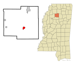
Coffeeville is a town in and one of two county seats of Yalobusha County, Mississippi, United States. The population was 905 at the 2010 census. It is named after John Coffee (1772–1833), a planter and military leader. The minor American Civil War Battle of Coffeeville took place near here in December 1862.

Scotsdale is a village in Jefferson County, Missouri, United States. The population was 222 at the 2010 census.

Cedar Creek is a village in Cass County, Nebraska, United States. The population was 465 at the 2020 census.

Tulare is a town in Spink County, South Dakota, United States. The population was 211 at the 2020 census.
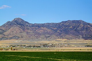
Plymouth is a town in Box Elder County, Utah, United States. The population was 414 at the 2010 census.

West Hamlin is a town in Lincoln County, West Virginia, United States, along the Guyandotte River. The population was 519 at the 2020 census, and is now down to 509, according to the 2021 census. West Hamlin is a part of the Huntington-Ashland, WV-KY-OH, Metropolitan Statistical Area (MSA). West Hamlin is west of the county seat at Hamlin, hence the name.

Iaeger is a town in McDowell County, West Virginia, United States. The population was 257 at the 2020 census.

Elk Garden is a town in Mineral County, West Virginia, United States. It is part of the 'Cumberland, MD-WV Metropolitan Statistical Area'. The population was 211 at the 2020 census. Elk Garden High School was consolidated into Keyser High School in 1997. However the Primary School is still in session, offering classes from Pre-Kindergarten through the fifth grade. The school mascot is the Elk Garden Stags. Elk Garden was incorporated in 1890 by the Mineral County Circuit Court. It is named for an elk lick near the original town site.

North Hills is a town in Wood County, West Virginia, United States. It is a suburb of Parkersburg. The population was 837 at the 2020 census. North Hills was incorporated on February 15, 1979.

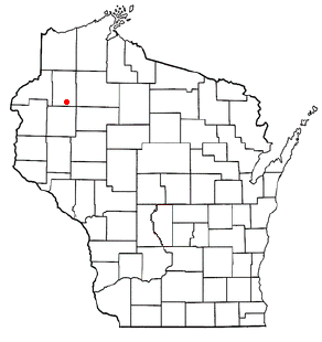
Grant is a town in Monroe County, Wisconsin, United States. The population was 483 at the 2000 census.
Akan is a town in Richland County, Wisconsin, United States. The population was 444 at the 2000 Census. The unincorporated communities of Five Points and Jimtown are located in the town.

Lenroot is a town in Sawyer County, Wisconsin, United States. The population was 1,165 at the 2000 census. The unincorporated communities of Seeley and Phipps are located in the town.
Long Lake is a town in Washburn County, Wisconsin, United States. The population was 737 at the 2000 census. The unincorporated community of Nobleton is located in the town.
Hulett is a town in Crook County, Wyoming, United States. The population was 309 at the 2020 census.

Rothsay is a city in Otter Tail and Wilkin counties in the State of Minnesota. The population was 498 at the 2020 census. One of Rothsay's major tourist attractions is the large prairie chicken statue near the northwest outskirts of the town.
Ridgeway is a town in Iowa County, Wisconsin, United States. The population was 563 at the 2020 census. The Village of Ridgeway is located within the town. The unincorporated community of Hyde is also located in the town.
Wilton is a town in Monroe County, Wisconsin, United States. The population was 925 at the 2000 census. The Village of Wilton is located partially within the town.
Clear Lake is a town in Polk County, Wisconsin, United States. The population was 800 at the 2000 census. The Village of Clear Lake is located within the town.
Hancock founded in 1850 is a town in Waushara County, Wisconsin, United States. The population was 531 at the 2000 census. The Village of Hancock is located within the town.

