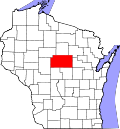
Evergreen, Marathon County, Wisconsin

Last updated
Evergreen
Former CDP
USA Wisconsin location map.svg
Red pog.svg
Evergreen
Location within the state of Wisconsin
Coordinates: 44°50′50″N89°37′39″W / 44.84722°N 89.62750°W / 44.84722; -89.62750 Coordinates: 44°50′50″N89°37′39″W / 44.84722°N 89.62750°W / 44.84722; -89.62750
Country United States
State Wisconsin
County Marathon
Area
  Total3.8 sq mi (9.9 km2)
  Land3.8 sq mi (9.9 km2)
Population
 (2000)
  Total3,611
  Density940/sq mi (360/km2)
Time zone UTC-6 (Central (CST))
  Summer (DST) UTC-5 (CDT)
Area code(s) 715 & 534

Evergreen is a former census-designated place (CDP) in Marathon County, Wisconsin, United States. The population was 3,611 at the 2000 census. Evergreen is now part of the village of Kronenwetter, which was incorporated on June 17, 2003. [1]

Contents

Geography

Evergreen is located at 44°50′50″N89°37′39″W / 44.84722°N 89.62750°W / 44.84722; -89.62750 (44.847312, -89.627491). [2]

According to the United States Census Bureau, the CDP had a total area of 3.8 square miles (9.9 km2), all of it land.

Demographics

As of the census [3] of 2000, there were 3,611 people, 1,228 households, and 1,015 families residing in the CDP. The population density was 946.5 people per square mile (365.9/km2). There were 1,267 housing units at an average density of 332.1/sq mi (128.4/km2). The racial makeup of the CDP was 98.20% White, 0.08% African American, 0.22% Native American, 1.11% Asian, 0.17% from other races, and 0.22% from two or more races. Hispanic or Latino of any race were 0.22% of the population.

There were 1,228 households, out of which 46.3% had children under the age of 18 living with them, 72.9% were married couples living together, 6.5% had a female householder with no husband present, and 17.3% were non-families. 11.8% of all households were made up of individuals, and 2.3% had someone living alone who was 65 years of age or older. The average household size was 2.91 and the average family size was 3.18.

In the CDP, the population was spread out, with 30.6% under the age of 18, 7.2% from 18 to 24, 32.5% from 25 to 44, 25.0% from 45 to 64, and 4.7% who were 65 years of age or older. The median age was 34 years. For every 100 females, there were 104.4 males. For every 100 females age 18 and over, there were 102.8 males.

The median income for a household in the CDP was $58,774, and the median income for a family was $61,699. Males had a median income of $38,784 versus $27,796 for females. The per capita income for the CDP was $21,467. About 4.6% of families and 4.6% of the population were below the poverty line, including 5.9% of those under age 18 and 12.9% of those age 65 or over.

Related Research Articles

Rock Creek, Alabama CDP in Alabama, United States

Rock Creek is a census-designated place in Jefferson County, Alabama, United States. Its location is northwest of Hueytown. At the 2010 census the population was 1,456. This area was damaged by an F5 tornado on April 8, 1998. An EF2 tornado struck northwest from here on January 23, 2012.

Shaver Lake, California Census-designated place in California, United States

Shaver Lake is a census-designated place (CDP) in Fresno County, California, United States. The population was 634 at the 2010 census, down from 705 at the 2000 census. Shaver Lake is on the southwest end of the lake of the same name, 10 miles (16 km) east of New Auberry, at an elevation of 5,627 ft (1,715 m). The name honors C.B. Shaver, founder of the Fresno Flume and Irrigation Company that built the dam, creating the lake. The lake served as a mill pond for the Shaver Sawmill and the source for a flume that ran 42 miles (68 km) to Clovis, CA. The original town of Shaver was buried under the lake when the Thomas A. Edison Company purchased and enlarged the lake in 1919.

Sarasota Springs, Florida Census-designated place in Florida, United States

Sarasota Springs is a census-designated place (CDP) in Sarasota County, Florida, United States. The population was 14,395 at the 2010 census. It is part of the Bradenton–Sarasota–Venice Metropolitan Statistical Area.

Rome is a census-designated place (CDP) in Medina Township, Peoria County, Illinois, United States. The population of the CDP was 1,738 at the 2010 census. Rome is part of the Peoria, Illinois Metropolitan Statistical Area.

West Ferriday, Louisiana Unincorporated Community in Louisiana, United States

West Ferriday is an Unincorporated Community in Concordia Parish, Louisiana, United States. The population was 1,541 at the 2000 census. The area was not delineated as a CDP for the 2010 census.

Cranbury (CDP), New Jersey Census-designated place in New Jersey, United States

Cranbury is an unincorporated community and census-designated place (CDP) located within Cranbury Township, in Middlesex County, New Jersey, United States. As of the 2010 United States Census, the CDP's population was 2,181. Despite the similarity in the name of Cranbury Township and the CDP, the two are not one and the same, as had been the case for most paired Township / CDP combinations prior to the 2010 Census, in which the CDP was coextensive with a township of the same name.

Brasher Falls–Winthrop, New York Former census-designated place in New York, United States

Brasher Falls–Winthrop was a census-designated place (CDP) in St. Lawrence County, New York, United States. As of the 2000 census, its population was 1,140. For the 2010 census, the area was counted as two separate CDPs: Brasher Falls in the Town of Brasher and Winthrop in the Town of Stockholm.

West Wyomissing, Pennsylvania Census-designated place in Pennsylvania, United States

West Wyomissing is a census-designated place (CDP) in Spring Township, Berks County, Pennsylvania, United States. The population was 3,407 at the 2010 census.

Arlington Heights, Pennsylvania Census-designated place in Pennsylvania, United States

Arlington Heights is a census-designated place (CDP) in Monroe County, Pennsylvania, United States. The population was 6,333 at the 2010 census. One notable location in Arlington Heights is the Stroud Mall.

Branchdale, Pennsylvania CDP in Pennsylvania, United States

Branchdale is a census-designated place (CDP) in Schuylkill County, Pennsylvania, United States. The population was 436 at the 2000 census.

Parkville, Pennsylvania CDP in Pennsylvania, United States

Parkville is a census-designated place (CDP) in York County, Pennsylvania, United States. The population was 6,706 at the 2010 census.

North Spearfish, South Dakota Census-designated place in South Dakota, United States

North Spearfish is a census-designated place (CDP) in Lawrence County, South Dakota, United States. The population was 2,221 at the 2010 census.

Warm Beach, Washington CDP in Washington, United States

Warm Beach is a census-designated place (CDP) in Snohomish County, Washington, United States. The population was 2,437 at the 2010 census.

Lake Wazeecha, Wisconsin CDP in Wisconsin, United States

Lake Wazeecha is a census-designated place (CDP) in the town of Grand Rapids, Wood County, Wisconsin, United States. The population was 2,651 at the 2010 census.

Andover (CDP), Massachusetts Census-designated place in Massachusetts, United States

Andover is a census-designated place (CDP) in the town of Andover in Essex County, Massachusetts, United States. The population was 8,762 at the 2010 census.

Oxford (CDP), Massachusetts CDP in Massachusetts, United States

Oxford is a census-designated place (CDP) in the town of Oxford in Worcester County, Massachusetts, United States. The population was 6,103 at the 2010 census.

Yorkshire (CDP), New York Census-designated place in New York, United States

Yorkshire is a census-designated place (CDP) in the northeastern corner of the town of Yorkshire in Cattaraugus County, New York, United States. The population of the CDP was 1,180 at the 2010 census, out of 3,913 in the town of Yorkshire as a whole.

Altona (CDP), New York Census-designated place in New York, United States

Altona is a hamlet and census-designated place (CDP) in the town of Altona, Clinton County, New York, United States. The population was 730 at the 2010 census, out of a total town population of 2,887.

Pine Plains (CDP), New York Census-designated place in New York, United States

Pine Plains is a hamlet and census-designated place (CDP) in Dutchess County, New York, United States. The population was 1,353 at the 2010 census. It is part of the Poughkeepsie–Newburgh–Middletown, NY Metropolitan Statistical Area as well as the larger New York–Newark–Bridgeport, NY-NJ-CT-PA Combined Statistical Area.

Rib Mountain (CDP), Wisconsin CDP in Wisconsin, United States

Rib Mountain is a census-designated place (CDP) in the town of Rib Mountain in Marathon County, Wisconsin, United States. The population was 5,651 at the 2010 census.

References

  1. Population Estimates Boundary Changes Archived August 6, 2010, at the Wayback Machine , United States Census Bureau, 2007-07-01. Accessed 2008-11-05.
  2. "US Gazetteer files: 2010, 2000, and 1990". United States Census Bureau. 2011-02-12. Retrieved 2011-04-23.CS1 maint: discouraged parameter (link)
  3. "U.S. Census website". United States Census Bureau . Retrieved 2008-01-31.CS1 maint: discouraged parameter (link)