Attimis is a comune (municipality) in the Regional decentralization entity of Udine in the Italian region of Friuli-Venezia Giulia, located about 70 kilometres (43 mi) northwest of Trieste and about 14 kilometres (9 mi) northeast of Udine.

Bicinicco is a comune (municipality) in the Regional decentralization entity of Udine in the Italian region of Friuli-Venezia Giulia, located about 50 kilometres (31 mi) northwest of Trieste and about 15 kilometres (9 mi) south of Udine.
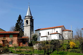
Cassacco is a comune (municipality) in the Regional decentralization entity of Udine in the Italian region of Friuli-Venezia Giulia, located about 80 kilometres (50 mi) northwest of Trieste and about 12 kilometres (7 mi) northwest of Udine. As of 31 December 2004, it had a population of 2,880 and an area of 11.6 square kilometres (4.5 sq mi).

Chiusaforte is a comune (municipality) in the Regional decentralization entity of Udine in the Italian region of Friuli-Venezia Giulia.
Drenchia is a comune (municipality) in the Regional decentralization entity of Udine in the Italian region of Friuli-Venezia Giulia, located about 60 kilometres (37 mi) north of Trieste and about 35 kilometres (22 mi) northeast of Udine, on the border with Slovenia. Drenchia is located on the western slopes of the Kolovrat Range, dividing Italy from Slovenia, and borders the following municipalities: Grimacco, Kanal ob Soči (Slovenia), Kobarid (Slovenia), and Tolmin (Slovenia).
Grimacco is a comune (municipality) in the Regional decentralization entity of Udine in the Italian region Friuli-Venezia Giulia, located about 60 kilometres (37 mi) northwest of Trieste and about 25 kilometres (16 mi) northeast of Udine, on the border with Slovenia, and borders the following municipalities: Drenchia, Kanal ob Soči (Slovenia), Kobarid (Slovenia), San Leonardo, Savogna, Stregna.

Lusevera is a comune (municipality) in the Regional decentralization entity of Udine in the Italian region of Friuli-Venezia Giulia, located about 80 kilometres (50 mi) northwest of Trieste and about 20 kilometres (12 mi) north of Udine, on the border with Slovenia, and borders the following municipalities: Gemona del Friuli, Kobarid (Slovenia), Montenars, Nimis, Resia, Taipana, Tarcento, and Venzone.

Pavia di Udine is a comune (municipality) in the Regional decentralization entity of Udine in the Italian region of Friuli-Venezia Giulia, located about 60 kilometres (37 mi) northwest of Trieste and about 9 kilometres (6 mi) southeast of Udine.

Povoletto is a comune (municipality) in the Regional decentralization entity of Udine in the Italian region of Friuli-Venezia Giulia, located about 70 kilometres (43 mi) northwest of Trieste and about 7 kilometres (4 mi) northeast of Udine. As of 31 December 2004, it had a population of 5,500 and an area of 39.0 square kilometres (15.1 sq mi).

Prepotto is a comune (municipality) in the Regional decentralization entity of Udine in the Italian region of Friuli-Venezia Giulia, located about 50 kilometres (31 mi) northwest of Trieste and about 20 kilometres (12 mi) east of Udine, on the border with Slovenia. As of 31 December 2004, it had a population of 894 and an area of 33.2 square kilometres (12.8 sq mi).
Pulfero is a comune (municipality) in the Regional decentralization entity of Udine in the Italian region Friuli-Venezia Giulia, located about 60 kilometres (37 mi) northwest of Trieste and about 20 kilometres (12 mi) northeast of Udine, on the border with Slovenia, and borders the following municipalities: Faedis, Kobarid (Slovenia), San Pietro al Natisone, Savogna, and Torreano.
Remanzacco is a comune (municipality) in the Regional decentralization entity of Udine in the Italian region of Friuli-Venezia Giulia, located about 60 kilometres (37 mi) northwest of Trieste and about 7 kilometres (4 mi) northeast of Udine. As of 31 December 2004, it had a population of 5,774 and an area of 30.6 square kilometres (11.8 sq mi).

San Leonardo is a comune (municipality) in the Regional decentralization entity of Udine in the Italian region of Friuli-Venezia Giulia, located about 60 kilometres (37 mi) northwest of Trieste and about 25 kilometres (16 mi) east of Udine, and borders the following municipalities: Grimacco, San Pietro al Natisone, Savogna, Stregna, and Prepotto.
San Pietro al Natisone is a comune (municipality) in the Regional decentralization entity of Udine in the Italian region of Friuli-Venezia Giulia, located about 60 kilometres (37 mi) northwest of Trieste and about 20 kilometres (12 mi) northeast of Udine, and borders the following municipalities: Cividale del Friuli, San Leonardo, Savogna, Prepotto, Pulfero, and Torreano. Until 1878, its official Italian name was San Pietro degli Slavi, i.e. "Saint Peter of the Slavs".
Savogna is a comune (municipality) in the Regional decentralization entity of Udine in the Italian region of Friuli-Venezia Giulia, located about 60 kilometres (37 mi) northwest of Trieste and about 25 kilometres (16 mi) northeast of Udine, on the border with Slovenia.

Stregna is a comune (municipality) in the Regional decentralization entity of Udine in the Italian region of Friuli-Venezia Giulia, located about 60 kilometres (37 mi) northwest of Trieste and about 30 kilometres (19 mi) northeast of Udine, on the border with Slovenia, and borders the following municipalities: Grimacco, Kanal ob Soči (Slovenia), San Leonardo, and Prepotto. The name of the settlement comes from the Slovene word srednje, meaning "the middle one".

Taipana is a comune (municipality) in the Regional decentralization entity of Udine in the Italian region of Friuli-Venezia Giulia, located about 80 kilometres (50 mi) northwest of Trieste and about 20 kilometres (12 mi) northeast of Udine, on the border with Slovenia. As of 31 December 2004, it had a population of 737 and an area of 65.6 square kilometres (25.3 sq mi). According to the census 1971 74,4% of the population are Slovenes.
Tavagnacco is a comune (municipality) in the Regional decentralization entity of Udine in the Italian region of Friuli-Venezia Giulia, located about 70 kilometres (43 mi) northwest of Trieste and about 8 kilometres (5 mi) north of Udine. The municipal seat is in the frazione (borough) of Feletto Umberto.
Torreano is a comune (municipality) in the Regional decentralization entity of Udine in the Italian region of Friuli-Venezia Giulia, located about 60 kilometres (37 mi) northwest of Trieste and about 15 kilometres (9 mi) northeast of Udine, on the border with Slovenia. As of 31 December 2004, it had a population of 2,301 and an area of 34.9 square kilometres (13.5 sq mi). According to the census 1971 24,5% of the population are Slovenes.

Cormons or Cormòns is a comune (municipality) in the Regional decentralization entity of Gorizia in the Italian region of Friuli-Venezia Giulia, located about 45 kilometres (28 mi) northwest of Trieste and about 12 kilometres (7 mi) west of Gorizia, on the border with Slovenia.


