Torre di Santa Maria is a comune (municipality) in the Province of Sondrio in the Italian region Lombardy, located about 100 kilometres (62 mi) northeast of Milan and about 8 kilometres (5 mi) north of Sondrio. As of 31 December 2004, it had a population of 884 and an area of 45.5 square kilometres (17.6 sq mi).

Ampezzo is a comune (municipality) in the Regional decentralization entity of Udine in the Italian region of Friuli-Venezia Giulia, located about 120 kilometres (75 mi) northwest of Trieste and about 50 kilometres (31 mi) northwest of Udine. As of 31 December 2004, it had a population of 1,137 and an area of 73.5 square kilometres (28.4 sq mi).

Bicinicco is a comune (municipality) in the Regional decentralization entity of Udine in the Italian region of Friuli-Venezia Giulia, located about 50 kilometres (31 mi) northwest of Trieste and about 15 kilometres (9 mi) south of Udine.
Corno di Rosazzo is a comune (municipality) in the Regional decentralization entity of Udine in the Italian region of Friuli-Venezia Giulia, located about 45 kilometres (28 mi) northwest of Trieste and about 20 kilometres (12 mi) southeast of Udine. As of 31 December 2004, it had a population of 3,313 and an area of 12.5 square kilometres (4.8 sq mi).

Coseano is a comune (municipality) in the Regional decentralization entity of Udine in the Italian region of Friuli-Venezia Giulia, located about 80 kilometres (50 mi) northwest of Trieste and about 15 kilometres (9 mi) west of Udine.

Forni di Sotto is a comune (municipality) in the Regional decentralization entity of Udine in the Italian region of Friuli-Venezia Giulia, located about 120 kilometres (75 mi) northwest of Trieste and about 60 kilometres (37 mi) northwest of Udine. As of 31 December 2004, it had a population of 701 and an area of 93.0 square kilometres (35.9 sq mi).
Martignacco is a comune (municipality) in the Regional decentralization entity of Udine in the Italian region of Friuli-Venezia Giulia, located about 70 kilometres (43 mi) northwest of Trieste and about 9 kilometres (6 mi) northwest of Udine.

Moruzzo is a comune (municipality) in the Regional decentralization entity of Udine in the Italian region of Friuli-Venezia Giulia, located about 80 kilometres (50 mi) northwest of Trieste and about 11 kilometres (7 mi) northwest of Udine. As of 31 December 2004, it had a population of 2,240 and an area of 17.9 square kilometres (6.9 sq mi).

Pagnacco is a comune (municipality) in the Regional decentralization entity of Udine in the Italian region of Friuli-Venezia Giulia, located about 70 kilometres (43 mi) northwest of Trieste and about 7 kilometres (4 mi) northwest of Udine. As of 31 December 2004, it had a population of 4,824 and an area of 14.9 square kilometres (5.8 sq mi).
Pasian di Prato is a comune (municipality) in the Regional decentralization entity of Udine in the Italian region of Friuli-Venezia Giulia, located about 70 kilometres (43 mi) northwest of Trieste and about 3 kilometres (2 mi) southwest of Udine.

Pavia di Udine is a comune (municipality) in the Regional decentralization entity of Udine in the Italian region of Friuli-Venezia Giulia, located about 60 kilometres (37 mi) northwest of Trieste and about 9 kilometres (6 mi) southeast of Udine.
Porpetto is a comune (municipality) in the Regional decentralization entity of Udine in the Italian region of Friuli-Venezia Giulia, located about 50 kilometres (31 mi) northwest of Trieste and about 25 kilometres (16 mi) south of Udine. As of 31 December 2004, it had a population of 2,717 and an area of 19.7 square kilometres (7.6 sq mi).

Povoletto is a comune (municipality) in the Regional decentralization entity of Udine in the Italian region of Friuli-Venezia Giulia, located about 70 kilometres (43 mi) northwest of Trieste and about 7 kilometres (4 mi) northeast of Udine. As of 31 December 2004, it had a population of 5,500 and an area of 39.0 square kilometres (15.1 sq mi).
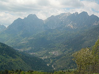
Prato Carnico is a comune (municipality) in the Regional decentralization entity of Udine in the Italian region of Friuli-Venezia Giulia, located about 120 kilometres (75 mi) northwest of Trieste and about 60 kilometres (37 mi) northwest of Udine. As of 9 October 2011, it had a population of 927 and an area of 81.3 square kilometres (31.4 sq mi).

Raveo is a comune (municipality) in the Regional decentralization entity of Udine in the Italian region of Friuli-Venezia Giulia, located about 110 kilometres (68 mi) northwest of Trieste and about 50 kilometres (31 mi) northwest of Udine. As of 31 December 2004, it had a population of 486 and an area of 12.7 square kilometres (4.9 sq mi).
Remanzacco is a comune (municipality) in the Regional decentralization entity of Udine in the Italian region of Friuli-Venezia Giulia, located about 60 kilometres (37 mi) northwest of Trieste and about 7 kilometres (4 mi) northeast of Udine. As of 31 December 2004, it had a population of 5,774 and an area of 30.6 square kilometres (11.8 sq mi).
Rive d'Arcano is a comune (municipality) in the Regional decentralization entity of Udine in the Italian region of Friuli-Venezia Giulia, located about 80 kilometres (50 mi) northwest of Trieste and about 15 kilometres (9 mi) northwest of Udine. As of 31 December 2004, it had a population of 2,363 and an area of 22.5 square kilometres (8.7 sq mi).
Varmo is a comune (municipality) in the Regional decentralization entity of Udine in the Italian region of Friuli-Venezia Giulia, located about 70 kilometres (43 mi) northwest of Trieste and about 30 kilometres (19 mi) southwest of Udine.
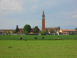
Santa Maria la Fossa is a comune (municipality) in the Province of Caserta in the Italian region Campania, located about 30 kilometres (19 mi) northwest of Naples and about 15 kilometres (9 mi) west of Caserta.
San Tammaro is a comune (municipality) in the Province of Caserta in the Italian region Campania, located about 30 kilometres (19 mi) north of Naples and about 9 kilometres (6 mi) west of Caserta.