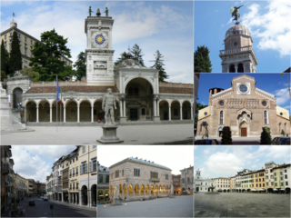
Udine is a city and comune (municipality) in northeastern Italy, in the middle of the Friuli-Venezia Giulia region, between the Adriatic Sea and the Carnic Alps. It is the capital of the Regional decentralization entity of Udine. Its population was 100,514 in 2012, 176,000 with the urban area.

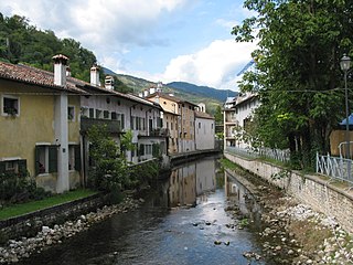
Cividale del Friuli is a town and comune (municipality) in the Regional decentralization entity of Udine, part of the North-Italian region of Friuli-Venezia Giulia. The town lies 135 metres (443 ft) above sea-level in the foothills of the eastern Alps, 15 kilometres (9 mi) by rail from the city of Udine and close to the Slovenian border. It is situated on the river Natisone, which forms a picturesque ravine here. Formerly an important regional power, it is today a quiet, small town that attracts tourists thanks to its medieval center.

Concordia Sagittaria is a town and comune in the Metropolitan City of Venice, Veneto, Italy.
Corno di Rosazzo is a comune (municipality) in the Regional decentralization entity of Udine in the Italian region of Friuli-Venezia Giulia, located about 45 kilometres (28 mi) northwest of Trieste and about 20 kilometres (12 mi) southeast of Udine. As of 31 December 2004, it had a population of 3,313 and an area of 12.5 square kilometres (4.8 sq mi).
Dignano is a comune (municipality) in the Regional decentralization entity of Udine in the Italian region of Friuli-Venezia Giulia, located about 80 kilometres (50 mi) northwest of Trieste and about 25 kilometres (16 mi) west of Udine.

Faedis is a comune (municipality) in the Regional decentralization entity of Udine in the Italian region of Friuli-Venezia Giulia, located about 70 kilometres (43 mi) northwest of Trieste and about 13 kilometres (8 mi) northeast of Udine, on the border with Slovenia.

Pozzuolo del Friuli is a comune (municipality) in the Regional decentralization entity of Udine in the Italian region of Friuli-Venezia Giulia, located about 60 kilometres (37 mi) northwest of Trieste and about 10 kilometres (6 mi) southwest of Udine.
Premariacco is a comune (municipality) in the Regional decentralization entity of Udine in the Italian region of Friuli-Venezia Giulia, located about 60 kilometres (37 mi) northwest of Trieste and about 13 kilometres (8 mi) east of Udine.

Prepotto is a comune (municipality) in the Regional decentralization entity of Udine in the Italian region of Friuli-Venezia Giulia, located about 50 kilometres (31 mi) northwest of Trieste and about 20 kilometres (12 mi) east of Udine, on the border with Slovenia. As of 31 December 2004, it had a population of 894 and an area of 33.2 square kilometres (12.8 sq mi).
Remanzacco is a comune (municipality) in the Regional decentralization entity of Udine in the Italian region of Friuli-Venezia Giulia, located about 60 kilometres (37 mi) northwest of Trieste and about 7 kilometres (4 mi) northeast of Udine. As of 31 December 2004, it had a population of 5,774 and an area of 30.6 square kilometres (11.8 sq mi).
Rive d'Arcano is a comune (municipality) in the Regional decentralization entity of Udine in the Italian region of Friuli-Venezia Giulia, located about 80 kilometres (50 mi) northwest of Trieste and about 15 kilometres (9 mi) northwest of Udine. As of 31 December 2004, it had a population of 2,363 and an area of 22.5 square kilometres (8.7 sq mi).
San Pietro al Natisone is a comune (municipality) in the Regional decentralization entity of Udine in the Italian region of Friuli-Venezia Giulia, located about 60 kilometres (37 mi) northwest of Trieste and about 20 kilometres (12 mi) northeast of Udine, and borders the following municipalities: Cividale del Friuli, San Leonardo, Savogna, Prepotto, Pulfero, and Torreano. Until 1878, its official Italian name was San Pietro degli Slavi, i.e. "Saint Peter of the Slavs".
San Vito al Torre is a comune (municipality) in the Regional decentralization entity of Udine in the Italian region Friuli-Venezia Giulia, located about 45 kilometres (28 mi) northwest of Trieste and about 20 kilometres (12 mi) southeast of Udine.
Torreano is a comune (municipality) in the Regional decentralization entity of Udine in the Italian region of Friuli-Venezia Giulia, located about 60 kilometres (37 mi) northwest of Trieste and about 15 kilometres (9 mi) northeast of Udine, on the border with Slovenia. As of 31 December 2004, it had a population of 2,301 and an area of 34.9 square kilometres (13.5 sq mi). According to the census 1971 24,5% of the population are Slovenes.
Zuglio is a comune (municipality), former bishopric and Latin Catholic titular see in the Regional decentralization entity of Udine in the northeastern Italian autonomous region of Friuli-Venezia Giulia, located about 110 kilometres (68 mi) northwest of Trieste and about 45 kilometres (28 mi) northwest of Udine, in the Val Bût.

Forgaria nel Friuli is a comune (municipality) in the Regional decentralization entity of Udine, in the Italian region of Friuli-Venezia Giulia, located about 90 kilometres (56 mi) northwest of Trieste and about 25 kilometres (16 mi) northwest of Udine. As of 31 December 2004, it had a population of 1,944 and an area of 29.2 square kilometres (11.3 sq mi).

Erto e Casso is a comune (municipality) in the Regional decentralization entity of Pordenone in the Italian region of Friuli-Venezia Giulia, located about 130 kilometres (81 mi) northwest of Trieste and about 40 kilometres (25 mi) northwest of Pordenone.

Montereale Valcellina is a comune (municipality) in the Regional decentralization entity of Pordenone in the northeast Italian region of Friuli-Venezia Giulia. The comune is located about 110 kilometres (68 mi) northwest of Trieste and about 20 kilometres (12 mi) north of Pordenone.

Pinzano al Tagliamento is a comune (municipality) in the Regional decentralization entity of Pordenone, in the Italian region of Friuli-Venezia Giulia, located about 90 kilometres (56 mi) northwest of Trieste and about 35 kilometres (22 mi) northeast of Pordenone.
Polcenigo is a comune (municipality) in the Regional decentralization entity of Pordenone in the Italian region Friuli-Venezia Giulia, located about 110 kilometres northwest of Trieste, 95 kilometres (59 mi) north of Venice and about 14 kilometres (9 mi) northwest of Pordenone.


