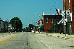
Farmington, Illinois | |
---|---|
Coordinates: 40°41′49″N90°00′08″W / 40.69694°N 90.00222°W [1] | |
Country | United States |
State | Illinois |
Counties | Fulton |
Townships | Farmington |
Government | |
• Mayor | Kenn Stufflebeam |
Area | |
• Total | 1.50 sq mi (3.90 km2) |
• Land | 1.50 sq mi (3.90 km2) |
• Water | 0.00 sq mi (0.00 km2) |
Elevation | 742 ft (226 m) |
Population (2020) | |
• Total | 2,389 |
• Density | 1,587.38/sq mi (612.69/km2) |
Time zone | UTC-6 (CST) |
• Summer (DST) | UTC-5 (CDT) |
ZIP Code(s) | 61531 |
Area code | 309 |
FIPS code | 17-25531 |
GNIS ID | 2394746 [1] |
Wikimedia Commons | Farmington, Illinois |
Website | www |
Farmington is a city in Fulton County & Peoria County, Illinois, United States. It is north of Canton, west of Peoria, southeast of Galesburg, and northeast of Macomb. The population was 2,389 at the 2020 census. [3] The public school system is Farmington Central Community Unit School District 265, which includes Farmington Central High School. Because it is in Fulton County & Peoria County, it is a part of the Canton Micropolitan Area and the wider Peoria Consolidated Statistical Area.
Farmington was founded circa 1827. The area was first inhabited by members of the Potawatomi tribe. [4] The city is named after Farmington, Connecticut. [5]
Before and during the Civil War, the city was involved in the Underground Railroad, and there are several remaining homes that were safehouses. In the early 1900s, many Italian immigrants settled in Farmington.
Farmington is located in the northeast corner of Fulton County. Illinois Routes 78 and 116 pass through the center of the city. IL 116 enters from the north as North Main Street, and IL 78 enters from the south as South Main Street. The two highways leave the city to the east on East Fort Street. IL 78 leads north 42 miles (68 km) to Kewanee and south 10 miles (16 km) to Canton, the largest city in Fulton County, while IL 116 leads east 22 miles (35 km) to Peoria and west 22 miles to St. Augustine.
According to the 2021 census gazetteer files, Farmington has a total area of 1.51 square miles (3.91 km2), all land. [6]
Census | Pop. | Note | %± |
---|---|---|---|
1880 | 1,111 | — | |
1890 | 1,375 | 23.8% | |
1900 | 1,729 | 25.7% | |
1910 | 2,421 | 40.0% | |
1920 | 2,631 | 8.7% | |
1930 | 2,269 | −13.8% | |
1940 | 2,225 | −1.9% | |
1950 | 2,651 | 19.1% | |
1960 | 2,831 | 6.8% | |
1970 | 2,959 | 4.5% | |
1980 | 3,118 | 5.4% | |
1990 | 2,535 | −18.7% | |
2000 | 2,601 | 2.6% | |
2010 | 2,448 | −5.9% | |
2020 | 2,389 | −2.4% | |
U.S. Decennial Census [7] |
As of the 2020 census [3] there were 2,389 people, 827 households, and 517 families residing in the city. The population density was 1,587.38 inhabitants per square mile (612.89/km2). There were 1,119 housing units at an average density of 743.52 per square mile (287.07/km2). The racial makeup of the city was 94.94% White, 0.17% African American, 0.21% Native American, 0.00% Asian, 0.08% Pacific Islander, 0.59% from other races, and 4.02% from two or more races. Hispanic or Latino of any race were 1.84% of the population.
There were 827 households, out of which 33.4% had children under the age of 18 living with them, 42.56% were married couples living together, 12.94% had a female householder with no husband present, and 37.48% were non-families. 32.41% of all households were made up of individuals, and 14.03% had someone living alone who was 65 years of age or older. The average household size was 2.99 and the average family size was 2.34.
The city's age distribution consisted of 25.8% under the age of 18, 10.3% from 18 to 24, 23.7% from 25 to 44, 23.6% from 45 to 64, and 16.8% who were 65 years of age or older. The median age was 34.8 years. For every 100 females, there were 106.3 males. For every 100 females age 18 and over, there were 104.1 males.
The median income for a household in the city was $51,335, and the median income for a family was $59,181. Males had a median income of $44,464 versus $31,548 for females. The per capita income for the city was $26,332. About 6.0% of families and 8.5% of the population were below the poverty line, including 3.8% of those under age 18 and 6.7% of those age 65 or over.
Peoria County is located in the U.S. state of Illinois. The 2020 United States Census listed its population at 181,830. Its county seat is Peoria. Peoria County is part of the Peoria metropolitan area.
Fulton County is a county in the U.S. state of Illinois. According to the 2020 census, it had a population of 33,609. Its county seat is Lewistown, and the largest city is Canton. Fulton County comprises the Canton, IL Micropolitan Statistical Area, which is part of the Peoria-Canton, IL Combined Statistical Area.
Banner is a village in Fulton County, Illinois, United States. The population was 169 at the 2020 census.
Canton is the largest city in Fulton County, Illinois, United States. The population was 13,242 at the 2020 census, down from 14,704 at the 2010 census. The Canton Micropolitan Statistical Area covers all of Fulton County; it is in turn, part of the wider Peoria–Canton, Illinois Combined Statistical Area (CSA).
Lewistown is a city and the county seat of Fulton County, Illinois, United States. It was named by its founder, Ossian M. Ross, after his oldest son, Lewis Winans Ross. The population was 2,041 at the 2020 census. Located in central Illinois, it is southwest of Peoria. It is the source of Spoon River Anthology by Edgar Lee Masters, who lived there. Native American burial mounds are nearby at Dickson Mounds off Illinois Route 97.
Liverpool is a village in Fulton County, Illinois, United States. The population was 94 at the 2010 census.
London Mills is a village in Fulton and Knox counties in the U.S. state of Illinois. The population was 350 at the 2020 census.
Norris is a village in Fulton County, Illinois, United States. The population was 173 at the 2020 census.
Smithfield is a village in Fulton County, Illinois, United States. The population was 191 at the 2020 census. The village is named in honor of Dr. Joseph N. Smith.
St. David is a village in Fulton County, Illinois, United States. The population was 522 at the 2020 census.
Havana is a city and the county seat of Mason County, Illinois, United States. The population was 2,963 at the 2020 census, a decline from the figure of 3,301 tabulated in 2010.
Hanna City is a village in Peoria County, Illinois, United States. The population was 1,225 at the 2010 census. Hanna City is part of the Peoria Metropolitan Statistical Area.
Buckheart Township is one of twenty-six townships in Fulton County, Illinois, USA. As of the 2020 census, its population was 1,315 and it contained 725 housing units.
Canton Township is one of twenty-six townships in Fulton County, Illinois, USA. As of the 2020 census, its population was 14,217 and it contained 6,284 housing units.
Ellisville Township is one of twenty-six townships in Fulton County, Illinois, USA. As of the 2020 census, its population was 135 and it contained 62 housing units.
Fairview Township is one of 26 townships in Fulton County, in the U.S. state of Illinois. As of the 2020 census, its population was 596 and it contained 285 housing units.
Farmington Township is one of twenty-six townships in Fulton County, Illinois, USA. As of the 2020 census, its population was 3,241 and it contained 1,484 housing units.
Isabel Township is one of twenty-six townships in Fulton County, Illinois, USA. At the 2020 census, its population was 175 and it contained 97 housing units.
Joshua Township is one of twenty-six townships in Fulton County, Illinois, USA. As of the 2020 census, its population was 465 and it contained 192 housing units.
Orion Township is one of twenty-six townships in Fulton County, Illinois, USA. As of the 2020 census, its population was 1,145 and it contained 513 housing units.