Flora of Saskatchewan

Last updated
Small Lady's Slipper - extirpated species Cypripedium candidum.jpg
Small Lady's Slipper - extirpated species
Silver buffaloberry Silver Buffaloberry.jpg
Silver buffaloberry
Canada thistle CanadaThistle.jpg
Canada thistle

The native flora of Saskatchewan includes vascular plants, plus additional species of other plants and plant-like organisms such as algae, lichens and other fungi, and mosses. Non-native species of plants are recorded as established outside of cultivation in Saskatchewan, of these some non-native species remain beneficial for gardening, and agriculture, where others have become invasive, noxious weeds. Saskatchewan is committed to protecting species at risk in Canada. The growing season has been studied and classified into plant hardiness zones depending on length of growing season and climatic conditions. Biogeographic factors have also been divided into vegetative zones, floristic kingdoms, hardiness zones and ecoregions across Saskatchewan, and natural vegetation varies depending on elevation, moisture, soil type landforms, and weather. The study of ethnobotany uncovers the interrelation between humans and plants and the various ways people have used plants for economic reasons, food, medicine and technological developments. The Government of Saskatchewan has declared 3 indigenous plants as provincial symbols.

Contents

Growing season

Saskatchewan possesses a continental climate and the seasonal variations in temperature provide a short growing season. On average the province supports 159 to 160 frost-free days, in the far north that number diminishes to 85 to 95 frost free days. [1] In 1967, Canadian scientists created a map outlining Plant Hardiness Zones. The hardiness zones examine climatic gradations such as length of frost-free period, summer rainfall, maximum summer temperatures, minimum winter temperatures, and wind speed. The harshest plant environment is 0 and the mildest is rated as 8. Corresponding data was correlated for plant requirements. Such an examination provides direction to which flora may survive the geographical hardiness zone conditions. [2] A development in the late 1800s encouraged homesteaders to pursue agriculture. Red Fife wheat (Triticum aestivum) matured 20 days before other wheats, which allowed plants to ripen before the autumn frost. [3]

Protected and invasive species

Saskatchewan has 367 rare species of vascular plants of which 135 of these have been listed as endangered. [4]

Saskatchewan's commitment to the Accord for the Protection of Species at Risk in Canada, which was ratified by provinces, territories and the federal government in September of 1998,"

Saskatchewan Environment and Resource Management Minister Lorne Scott (1999) [5]

There is listed Small White Lady's Slipper (Cypripedium candidum) as the only local extinction, (extirpated) plant. Endangered plants include the Sand Verbena (Abronia micrantha), Western Spiderwort ( Tradescantia occidentalis), Tiny Cryptantha ( Cryptantha minima ), and Hairy Prairie-Clover ( Dalea villosa). Threatened plants include the Slender Mouse-Ear Cress (Halimolobos virgata). [5] These two reports to aid in the protection of plants; Species at Risk In SK and Rare Plant Survey Guidelines. [6] Saskatchewan has implemented The Weed Control Act [7] to control plants introduced to Saskatchewan which have become a threat to the natural biodiversity such as leafy spurge (Euphorbia esula). [8] There are two reports in this regard; Invasive Species and Noxious Weeds of Saskatchewan. [6] [8]

Section 15 (1) of the Act states: "Every owner or occupant of land shall:

(a) under the supervision of the weed inspector, eradicate any prohibited weeds located on the land;

(b) under the supervision of the weed inspector, eradicate any isolated infestations of noxious weeds located on the land;

(c) contain and control any established infestations of noxious weeds located on the land; and

(d) take measures to control any nuisance weeds located on the land."

The Weed Control Act.

Provincial symbols

The tree which was designated in 1988 as a symbol of Saskatchewan is the paper birch Betula papyrifera. [9] Saskatchewan's provincial flower is the Western red lily Lilium philadelphicum var. andinum (a protected species ) designated in 1941. [10] Needle-and-thread grass Hesperostipa comata is Saskatchewan's provincial grass declared in 2001. [11]

Floristic kingdom

Saskatchewan is within the Holarctic Kingdom. There are two regions within this kingdom, the Circumboreal floristic region or which provides a cool northern temperate zone and the North American Atlantic Region in Southern Saskatchewan which is part of a warmer Midwestern Plains zone. These zones are characterized by a certain degree of endemism. [12]

Ecoregions

An ecoregion encompasses soil types and landform similarities. [13] :134 The Taiga Shield ecozone in the far north includes the Selwyn Lake upland and Tazin Lake Upland ecoregion. [13] :160 [14] This would have vegetation generally corresponding to the Subarctic Woodland. The Boreal Shield ecozone is further divided into the Athabasca Plain and Churchill River Upland, and this area of Northern Saskatchewan has been described by the World Wildlife Fund as part of the Midwestern Canadian Shield forests ecoregion. The Boreal Plains ecozone comprises the Mid-Boreal Upland, Mid-Boreal Lowland and Boreal Transition ecoregions. Further south is the Prairie ecozone which consists of the Aspen Parkland, Moist Mixed Prairie, Northern Mixed Grassland and Cypress Upland ecoregions. The ecoregions are further divided into Landscape Areas. [13] :160 [15] [16]

Vegetative zones

Several biogeographic factors contribute to the richness and diversity of Saskatchewan flora. From north to south there are a variety of vegetative zones. To the far north are the Subarctic Woodland and Northern Boreal Forest. The Southern Boreal Forest is south of the treeline. The Prairie is divided into the Aspen Parkland, Moist Mixed Grassland, Mixed Grassland, Cypress Upland and Fescue Grassland. In southeast Saskatchewan are Dry Mixed Prairie of the Great Sand Hills area and the Cypress Hills. [13]

Subarctic Woodland

Upon the Canadian Shield and in the coolest weather, are subarctic lichen woodland. [17] The black spruce (Picea Mariana), jack pine (Pinus banksiana), and white spruce (Picea glauca) are commonly occurring trees. This area is interspersed with peatlands, bogs, fens, permafrost areas, and areas of arctic tundra. [13] Yellow and Grey Reindeer moss (Cladonia mitis) provide ground cover. [17] The Subarctic Woodland corresponds to Canada's hardiness zone 0a. [18]

Northern Boreal Forest

The circumpolar boreal forest or taiga is dominated by conifers or aspen and poplar stands. [19]

Boreal forest Pawistik lodge.jpg
Boreal forest

Throughout this area are lakes, bogs, forest and rock outcroppings. [17] Black spruce, jack pine once again are the main trees of the area. Forest fires are a concern in this area, and Fireweed (Epilobium angustifolium) occurs in burnt areas. [13] Cladonia cetraria and C. tereocaulon are lichen species which provide ground cover. Feather mosses such as Stair-Step Moss (Hylocomium splendens) and Hypnum are amongst the undergrowth. [17] Where the rock is covered in soils, the forest takes on the characteristics and species of the Southern Boreal Forest ecozone. [13] The plant hardiness zone would be Zone 0b. [18]

The Athabasca Basin provides a separate ecosystem. The Athabasca Sand Hills protected by The Athabasca Sand Dunes Provincial Park are unique feature of the Canadian shield. The hills are located in northern Saskatchewan and border Lake Athabasca, which straddles the Alberta and Saskatchewan border. [20] [21] There is sparse plant life in the sand hills area. Blueberry, Bearberry (Arctostaphylos uva-ursi ), Sand Heather (Hudsonia tomentosa), Crowberry (Empetrum) and grasses survive here. [13] In this ecozone there are 10 species of endemic plants. There are unique four species of Willow (Salix). [22]

Southern Boreal Forest

Mixedwood boreal forest with jack pine, trembling aspen (Populus tremuloides ), white spruce, and tamarack (Larix laricina) populate the Southern Boreal Forest which also houses the forestry industry. [13] [17]

Bearberry Bearberry-uva-ursi.jpg
Bearberry

The ground cover is lichen and stairstep moss. Bearberry, low-bush cranberry (Vaccinium vitis-idaea), Red Osier Dogwood (Cornus sericea, syn. C. stolonifera, Swida sericea) predominate the shrub layer. [19] Peatlands, fens, marsh complexes occur with wetter soils such as those found above the basin of the Quaternary Glacial Lake Agassiz in the south eastern portion of the Southern Boreal Forest. [13] 16% of the boreal forest are wetlands which have a water table at or above ground level. [19] The province is the world's largest producer of wild rice. [23]

Mushrooms, lichens, moss and other bryophytes. Fungi of Saskatchewan.JPG
Mushrooms, lichens, moss and other bryophytes.

Bog Labrador Tea (Ledum groenlandicum), Sphagnum mosses, and cloudberry (Rubus chamaemorus) flourish in the peatland areas. [13] Bogs have a high acidic layer, high water table and low nutrients. [19] Fens support the brown mosses such as Drepanocladus, Brachythecium, Calliergonelia, Scorpidium, Campylium. Reed Grass (Calamagrostis), Willows, marsh cinquefoil (Potentilla), and False Solomon's Seal (Maianthemum racemosum) gow in fen regions. [13] Fens have a high water table with slow drainage which is rich in nutrients. [19] Marshes are surrounded by willows and support Marsh reed grass (Calamagrostis), Kentucky blue grass (Poa pratensis), Fowl blue grass (Poa palustris), beaked sedge (Carex rostrata), bulrush (Scirpus validus and S. acutus). [17] Marshes have slow moving slightly alkaline water and are very rich in nutrient and minerals. Bogs, fens, and marshes together comprise muskeg regions. [19] Hardiness zone 1a describes the Southern Boreal Forest. [18]

Aspen Parkland

The Aspen parkland corresponds to the Transitional Grassland Ecoclimatic Region with lower precipitation and a higher average annual temperature of about 1.3 °C (34.3 °F).

Saskatchewan Flower: Western red lily Protected species Lilium concolor.jpg
Saskatchewan Flower: Western red lily Protected species

Trembling aspen form bluffs (small islands or shelter belts) which are typical in this area. The Aspen Parkland is a transitional area between the mixed woodland and prairie grasslands. [24] The Aspen Parkland can be divided into eastern, central and western. The eastern area produces tall grass prairie featuring big bluestem (andropogon gerardi) and Porcupine grass (Stipa spartea). Trees in this area are Bur Oak, (Quercus macrocarpa), Green ash (Fraxinus pennsylvanica), Manitoba maple (Acer negundo), and balsam poplar (Populus sect. Tacamahaca) as well as aspen. Fescue grasses such as Festuca hallii and western porcupine grass (Stipa curtiseta) make up the native Fescue grasslands of central Saskatchewan. The aspen tree stands are still poplar, and interspersed with willow in wetter areas.

Tree: Paper Birch Brzoza paierowa Betula papyrifera.jpg
Tree: Paper Birch

The western parkland has ground cover of plains rough fescue Needle and thread grass (Hesperostipa comata). Tree groves are aspen, willows and balsam poplar. [19] Throughout the Aspen Parkland in low-lying areas with more moisture are dense shrub stands. Saskatoon (Amelanchier alnifolia), pin cherry (Prunus pensylvanica), choke cherry (Prunus virginiana), hawthorn (Crataegus), western snow berry (Symphoricarpos), woods rose ( Rosa woodsii ), Wolf willow (Elaeagnus commutata) and Canada buffaloberry (Shepherdia canadensis) are a few of the shrubs of the area. [13] The marshes and prairie sloughs of the Aspen Parkland support flora similar to the marshlands of the Southern Boreal Forest. [13] The Aspen Parkland ranges between 1b, 2a and 2b for plant hardiness areas. [18]

Mixed Prairie

Qu'Appelle Valley near Cutarm, Sask., circa 1910 Qu'Appelle Valley near Cutarm, Sask., circa 1910.jpeg
Qu'Appelle Valley near Cutarm, Sask., circa 1910

The Mixed Grass Prairie correlates to the Arid Grassland Ecoclimatic Region and hardiness zone 2a and 3a. [18] [24] Big sandgrass, blue grama (Bouteloua gracilis) grass grow in the higher dry areas. [24] At lower saline sites alkali grass (Puccinellia alroides), salt grass (Distichlis spicata), foxtail or wild barley (Hordeum jubatum), and arrowgrass (Triglochin maritima) are found. [17] Needle and thread grass, northern wheat grass (Elymus lanceolatus), hair sedge (Carex atherodes), bottle sedge (Carex rostrata) grow in the intermediate mesic sites, with cottonwoods and willow growing along riverbanks. [24]

Dry mixed prairie

Southwest Saskatchewan has very dry climatic conditions. Dry mixed prairie is found south of Cypress Hills and the Great Sand Hills area near Leader. Prickly pear cactus (Opuntia), blue grama grass, needle and thread grass, silver sagebrush (Artemisia cana) and June grass (Koeleria) are found in the areas. [13]

Cypress Hills

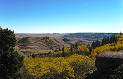
The Cypress Hills has an elevation over 1,200 metres (3,900 ft), with cooler resulting temperatures and higher precipitation which are more similar to the boreal forest than the prairie grasslands.

Cypress Hills CypressHills1.JPG
Cypress Hills

Lodgepole Pine (Pinus contorta) occurs only in the Cypress Hills area of Saskatchewan and also in the Rocky Mountain forests. Aspen, and white spruce are other trees of the Cypress Hills forests. Shining leaved meadowsweet ( Spiraea lucida ), low larkspur (Delphinium bicolor ), pinegrass (Calamagrostis rubescens ) provide ground cover.

Ethnobotany

There are many native plants of Saskatchewan which can be prepared as vegetables, teas, wine, jams, syrups and flour. Other plants have medicinal qualities. The harvest of various plants varies. Shoots, and leaves of some plants are harvested, while roots and tubers of others are picked like potatoes. When locating native plants, it is important to note which season to harvest them and what habitats to search for. Marshy pond edges reveal broad leaf cattail, or yellow pond lily (Nuphar advena).

Marsh area. Blueberry, strawberry, dewberry, plantain, shaggy mane mushrooms, cattail, Labrador tea, bearberry, strawberry blight, puffball mushrooms and wild mint can be harvested near this site. FlottenLakeRiverfront.JPG
Marsh area. Blueberry, strawberry, dewberry, plantain, shaggy mane mushrooms, cattail, Labrador tea, bearberry, strawberry blight, puffball mushrooms and wild mint can be harvested near this site.

Disturbed sites produce chickweed, and plantain (Musa). Asparagus (Asparagus officinalis) shoots grow near roadsides. There are plants which are poisonous, and edible plants which have poisonous look alike. [25]

Strawberry (Fragaria vesca), wild mint (Mentha arvensis), and Labrador tea leaves can be steeped in boiling water for tea. [19] Saskatoons, blueberries and other berries can be hand-picked for jam, jelly, syrup and juice preparation. Blackberry, dewberry, blueberry, buffaloberry, currant, huckleberry, prickly pear, raspberry, and rose hips all make delicious jams or jellies. Pies can be made of currants, blackberries, mountain ash, or strawberries, for example. Hull grass seeds and grind them down into flour. [25]

Herbal solutions used as remedies for ailments could be ingested as tea, used as ointments, or poultices or inhaled as smoke or steam from a decoction. Cow parsnip (Heracleum maximum) and broad-leaved water plantain (Alisma plantago-aquatica) are two herbal remedies which were cultivated by the Cree. [19] However, the cow parsnip does have a poisonous look-alike species, the western water hemlock, (Cicuta douglasii, poison hemlock). [25]

Flora of Saskatchewan have also aided humans in other ways; trees provide wood such as birch bark for canoes, reeds could be fashioned into whistles and baskets. Sphagnum mosses were used for their insulating qualities, as well mosses were absorbent for diapers, and had antibacterial properties. [19]

Botanists

Eugène Bourgeau (1813 - 1877) was the botanist who traveled with Captain John Palliser (1817–1887) and Henry Youle Hind (1823 - 1908) during the British North American Exploring Expedition.

Green Spurge or Leafy Spurge invasive species Euphorbia esula.jpeg
Green Spurge or Leafy Spurge invasive species

The results of these investigations between 1857 and 1861 resulted in reporting the area unsuitable for agriculture and an area of particularly dry land was named the Palliser's Triangle. [26] [27] John Macoun (1831-1920) was a naturalist who accompanied Sir Sanford Fleming to the prairies in 1872 and he offered agricultural possibilities for the region. [28] Isabel M. Priestly (1893-1946) was a botanist who made botanical collections and formed the Yorkton Natural History Society. [29] Dr. William P. Fraser is the namesake of the W.P. Fraser Herbarium. His botanical collection was donated to the Biology Department at the University of Saskatchewan where he was a professor. Later the Fraser collections were transferred to the Department of Plant Ecology in the College of Agriculture. [30] Dr. John K. Jeglum was a research botanist with Great Lakes Forestry Centre (GLFC). He received his doctorate at the University of Saskatchewan his thesis on Lowland vegetation at Candle Lake, Southern Boreal Forest Saskatchewan resulted in a collection of Saskatchewan specimens. [31]

Agriculture

Harvest time Fjeld1a.jpg
Harvest time

Agriculture in Saskatchewan is the production of various food, feed, or fiber commodities to fulfill domestic and international human and animal sustenance needs. The newest agricultural economy to be developed in renewable biofuel production or agricultural biomass which is marketed as ethanol or biodiesel. [32] cultivation and livestock production have abandoned subsistence agricultural practices in favor of intensive technological farming resulting in cash crops which contribute to the economy of Saskatchewan. The particular commodity produced is dependent upon its particular biogeography or ecozone of Geography of Saskatchewan. Agricultural techniques and activities have evolved over the years. The first nation nomadic hunter-gatherer lifestyle and the early immigrant ox and plow farmer proving up on his quarter section of land in no way resemble the present farmer operating huge amounts of land or livestock with their attendant technological mechanization. [33]

Grain field in the aspen parkland near Saskatoon Parkland near Saskatoon.jpg
Grain field in the aspen parkland near Saskatoon

Challenges to the future of Saskatchewan agriculture include developing sustainable water management strategies for a cyclical drought prone climate in south western Saskatchewan, updating dryland farming techniques, stabilizing organic definitions or protocols and the decision to grow, or not to grow genetically modified foods. Domestically and internationally, some commodities have faced increased scrutiny from disease and the ensuing marketing issues.

Canada's production of wheat, oats, flaxseed, and barley come mainly from Saskatchewan and the prairie provinces. [34] Saskatchewan still has cattle ranching along the southwestern corner of the province, However, grain farming and growing crops such as wheat, oats, flax, alfalfa, and rapeseed (especially canola ) dominate the parkland area. Mixed grain farming, dairy farms, mixed livestock and grazing lands dot the central lowlands region of this prairie province. [35] As of 1996, March 24 to 30, has been proclaimed Agriculture Week in Saskatchewan. [36]

Forestry

In the northern part of the province, forestry is significant. North of the treeline in Saskatchewan are 350,000 square kilometres (140,000 sq mi) of forests which provide resources for the Saskatchewan forestry industry. [37] The forestry industry comprises lumber and sodium sulphate for pulp and paper resources. [38]

Physiographic regions

Physiographic regions -with some of the area's main features [39]
Physiographic RegionBedrock GeologyDominant soilsNatural Vegetation
Canadian Shield
Rock knob complexIgneous rocks and Precambrian Missi SeriesLodzolic forest soilsLichen woodland
black spruce
pine
Athabasca PlainsPrecambrian Athabasca FormationRough rock land; bedrock exposurespine
Central Lowlands
Manitoba LowlandsCretaceous formationsChernozemic soilsAspen
fescue
spear/wheat grass
Saskatchewan PlainsCretaceous formationsChernozemic soilsAspen
fescue
spear/wheat grass
Great Plains
Alberta PlateauTertiary formationsRegozolic and solonetzic soil mixturesspear grass / blue grama

See also

Related Research Articles

<span class="mw-page-title-main">Geography of Canada</span>

Canada has a vast geography that occupies much of the continent of North America, sharing a land border with the contiguous United States to the south and the U.S. state of Alaska to the northwest. Canada stretches from the Atlantic Ocean in the east to the Pacific Ocean in the west; to the north lies the Arctic Ocean. Greenland is to the northeast with a shared border on Hans Island. To the southeast Canada shares a maritime boundary with France's overseas collectivity of Saint Pierre and Miquelon, the last vestige of New France. By total area, Canada is the second-largest country in the world, after Russia. By land area alone, however, Canada ranks fourth, the difference being due to it having the world's largest proportion of fresh water lakes. Of Canada's thirteen provinces and territories, only two are landlocked while the other eleven all directly border one of three oceans.

<span class="mw-page-title-main">Geography of Alberta</span> Physical features of the Canadian province

Alberta is one of the thirteen provinces and territories of Canada. Located in Western Canada, the province has an area of 661,190 km2 (255,290 sq mi) and is bounded to the south by the United States state of Montana along 49° north for 298 km (185 mi); to the east at 110° west by the province of Saskatchewan for 1,223 km (760 mi); and at 60° north the Northwest Territories for 644 km (400 mi). The southern half of the province borders British Columbia along the Continental Divide of the Americas on the peaks of the Rocky Mountains, while the northern half borders British Columbia along the 120th meridian west. Along with Saskatchewan it is one of only two landlocked provinces or territories.

<span class="mw-page-title-main">Canadian Prairies</span> Region of Western Canada

The Canadian Prairies is a region in Western Canada. It includes the Canadian portion of the Great Plains and the Prairie Provinces, namely Alberta, Saskatchewan, and Manitoba. These provinces are partially covered by grasslands, plains, and lowlands, mostly in the southern regions. The northernmost reaches of the Canadian Prairies are less dense in population, marked by forests and more variable topography. If the region is defined to include areas only covered by prairie land, the corresponding region is known as the Interior Plains. Physical or ecological aspects of the Canadian Prairies extend to northeastern British Columbia, but that area is not included in political use of the term.

<span class="mw-page-title-main">Tallgrass prairie</span> Ecosystem native to central North America

The tallgrass prairie is an ecosystem native to central North America. Historically, natural and anthropogenic fire, as well as grazing by large mammals provided periodic disturbances to these ecosystems, limiting the encroachment of trees, recycling soil nutrients, and facilitating seed dispersal and germination. Prior to widespread use of the steel plow, which enabled large scale conversion to agricultural land use, tallgrass prairies extended throughout the American Midwest and smaller portions of southern central Canada, from the transitional ecotones out of eastern North American forests, west to a climatic threshold based on precipitation and soils, to the southern reaches of the Flint Hills in Oklahoma, to a transition into forest in Manitoba.

<span class="mw-page-title-main">Aspen parkland</span> Temperate grasslands, savannas, and shrublands ecoregion of Canada and the United States

Aspen parkland refers to a very large area of transitional biome between prairie and boreal forest in two sections, namely the Peace River Country of northwestern Alberta crossing the border into British Columbia, and a much larger area stretching from central Alberta, all across central Saskatchewan to south central Manitoba and continuing into small parts of the US states of Minnesota and North Dakota. Aspen parkland consists of groves of aspen, poplar and spruce, interspersed with areas of prairie grasslands, also intersected by large stream and river valleys lined with aspen-spruce forests and dense shrubbery. This is the largest boreal-grassland transition zone in the world and is a zone of constant competition and tension as prairie and woodlands struggle to overtake each other within the parkland.

<span class="mw-page-title-main">Boreal Shield Ecozone (CEC)</span> Largest ecozone in Canada, stretching from Saskatchewan to Newfoundland

The Boreal Shield Ecozone, as defined by the Commission for Environmental Cooperation (CEC), is the largest ecozone in Canada. Covering 1.8 million square kilometres it covers almost 20% of Canada's landmass, stretching from northern Saskatchewan to Newfoundland.

<span class="mw-page-title-main">Geography of Manitoba</span>

The geography of Manitoba addresses the easternmost of the three prairie Canadian provinces, located in the longitudinal centre of Canada. Manitoba borders on Saskatchewan to the west, Ontario to the east, Nunavut to the north, and the American states of North Dakota and Minnesota to the south. Although the border with Saskatchewan appears straight on large-scale maps, it actually has many right-angle corners that give the appearance of a slanted line. In elevation, Manitoba ranges from sea level on Hudson Bay to 2727 ft (831 m) on top of Baldy Mountain. The northern sixty percent of the province is on the Canadian Shield. The northernmost regions of Manitoba lie permafrost, and a section of tundra bordering Hudson Bay.

<span class="mw-page-title-main">Geography of Saskatchewan</span> Geography of the prairie and boreal province of Saskatchewan, Canada

The geography of Saskatchewan is unique among the provinces and territories of Canada in some respects. It is one of only two landlocked regions and it is the only region whose borders are not based on natural features like lakes, rivers, or drainage divides. The borders of Saskatchewan, which make it very nearly a trapezoid, were determined in 1905 when it became a Canadian province. Saskatchewan has a total area of 651,036 square kilometres (251,366 sq mi) of which 591,670 km2 (228,450 sq mi) is land and 59,366 km2 (22,921 sq mi) is water.

Highway 3 is a major provincial highway in the Canadian province of Saskatchewan. It runs from the Alberta border, where it continues west as Alberta Highway 45, to the Manitoba border, and then continues east as Highway 77. Highway 3 is about 615 km (382 mi.) long. The CanAm Highway comprises Saskatchewan Highways 35, 39, 6, 3, as well as 2. 59.7 miles (96.1 km) of Saskatchewan Highway 3 contribute to the CanAm Highway between Melfort and Prince Albert.

The Manitoba Escarpment, or the Western Manitoba Uplands, are a range of hills along the Saskatchewan-Manitoba border. The eastern slopes of the range are considered to be a scarp. They were created by glacial scouring and formed the western shore of prehistoric Lake Agassiz.

<span class="mw-page-title-main">Boreal Plains Ecozone (CEC)</span> An ecozone

The Boreal Plains Ecozone, as defined by the Commission for Environmental Cooperation (CEC), is a terrestrial ecozone in the western Canadian provinces of Manitoba, Saskatchewan and Alberta. It also has minor extensions into northeastern British Columbia and south-central Northwest Territories. The region extends over 779,471 km2, of which 58,981 km2 is conserved.

<span class="mw-page-title-main">Prairies Ecozone</span>

The Prairies Ecozone is a Canadian terrestrial ecozone which spans the southern areas of the Prairie provinces of Alberta, Saskatchewan, and Manitoba. It is a productive agricultural area, and is commonly referred to as "Canada's breadbasket". Farmland covers about 94% of the land, and is the dominant domestic economic activity of the zone, as well as an important factor in Canadian foreign trade. Natural gas and oil are abundant in the area. The corresponding Level II ecoregion of the US Environmental Protection Agency is the Great Plains Ecoregion.

Carmichael is a special service area within the Rural Municipality of Carmichael No. 109, Saskatchewan, Canada that held village status prior to 2019. The population was 58 at the 2016 Census. Carmichael lies 1 km (1 mi) south of Highway 1 commonly known as the Trans Canada Highway, approximately 158 km (98 mi) east of city of Medicine Hat, Alberta.

<span class="mw-page-title-main">Wildlife of Canada</span> Overview of the wildlife of Canada

The wildlife of Canada or biodiversity of Canada consist of over 80,000 classified species, and an equal number thought yet to be recognized. Known fauna and flora have been identified from five kingdoms: protozoa represent approximately 1% of recorded species; chromist ; fungis ; plants ; and animals. Insects account for nearly 70 percent of documented animal species in Canada. More than 300 species are found exclusively in Canada.

<span class="mw-page-title-main">Fauna of Saskatchewan</span>

The Fauna of Saskatchewan include several diverse land and aquatic animal species. From the multiplicity of invertebrates and vertebrates, two have been chosen as symbols of Saskatchewan. Cenozoic vertebrate fossils reveal the geological evolution of the interior plains and its prehistoric biogeography. Today, Saskatchewan's ecosystems range from the sub-arctic tundra of the Canadian Shield in north Saskatchewan to aspen parkland, the Mid-Continental Canadian forests in the centre of the province and grassland prairie. Fauna inhabit areas unique to their own specific and varied breeding, foraging and nesting requirements. With a large land and water area, and small population density, the ecoregions of Saskatchewan provide important habitat for many animals, both endangered and not. Naturalists observing wildlife have enumerated shrinking and growing wildlife populations. They advocate programs and methods to preserve or re-introduce endangered species and identify programs of control for outbreaks of wildlife populations. A broad diversity of wildlife habitats are preserved as parks and reserves protecting the feeding and breeding grounds of protected and indigenous fauna of Saskatchewan.

The effects of climate change in Saskatchewan are now being observed in parts of the province. There is evidence of reduction of biomass in Saskatchewan's boreal forests that is linked by researchers to drought-related water stress stemming from global warming, most likely caused by greenhouse gas emissions. While studies, as early as 1988 have shown that climate change will affect agriculture, whether the effects can be mitigated through adaptations of cultivars, or crops, is less clear. Resiliency of ecosystems may decline with large changes in temperature. The provincial government has responded to the threat of climate change by introducing a plan to reduce carbon emissions, "The Saskatchewan Energy and Climate Change Plan", in June 2007.

<span class="mw-page-title-main">Northern mixed grasslands</span> Temperate grasslands, savannas, and shrublands ecoregion of Canada and the United States

The Northern Mixed Grasslands is one of 867 terrestrial ecoregions defined by the World Wide Fund for Nature. This ecoregion includes parts of the Canadian provinces of Alberta, Saskatchewan, and Manitoba, north-central and eastern North Dakota, most of east South Dakota, and north-central Nebraska in the American Great Plains. The United States Environmental Protection Agency (EPA) defines this ecoregion as the Northern Glaciated Plains.

Armit Meadows Ecological Reserve is an ecological reserve located in Porcupine Provincial Forest, Manitoba, Canada. It was established in 2015 under the Manitoba Ecological Reserves Act. It is 2.63 square kilometres (1.02 sq mi) in size.

Wood Mountain Hills are a hilly plateau in the Canadian province of Saskatchewan. The hills are located in the southern part of the province and are part of the Missouri Coteau, which is part of the Laurentian Divide between the watersheds of the Hudson Bay drainage basin of the Arctic Ocean and the Gulf of Mexico of the Atlantic Ocean. The hills are in a semi-arid region known as Palliser's Triangle in the Great Plains ecoregion of North America.

References

  1. "Plant Hardiness Zones in Canada". Agriculture and Agri-Food Canada CanSIS > National Soil DataBase (NSDB) > CLIMATE data > Plant Hardiness Zones. Government of Canada. 2008-11-27. Archived from the original on 2006-10-02. Retrieved 2009-01-25.
  2. "Saskatchewan (province) - MSN Encarta". Microsoft Corporation. 1993–2008. Archived from the original on 2009-10-31. Retrieved 2009-01-25.
  3. Adelman, Jeremy (1994). rontier Development: Land, Labour, and Capital on the Wheatlands of Argentina and Canada, 1890-1914 (Digitized online by Google books). Oxford University Press. ISBN   9780198204411. ISBN   0-19-820441-8
  4. "Rare Native Saskatchewan Plants - The Rare Native Vascular Plants of Saskatchewan". Sask Herbarium. University of Saskatchewan Plant Sciences Department. Archived from the original on July 11, 2009. Retrieved 2009-01-25.
  5. 1 2 "Wild Plants and Animals Protected". About Government/News Releases/March 1999/Wild Plants and Animals Protected. Government of Saskatchewan. March 1999. Archived from the original on 2010-11-24. Retrieved 2009-01-25.
  6. 1 2 "Saskatchewan Conservation Data Centre". About Government/News Releases/March 1999/Wild Plants and Animals Protected. 2008. Retrieved 2009-01-25.
  7. "The Weed Control Act (Sask)". Government of Saskatchewan. 2010. Retrieved 2019-05-08.
  8. 1 2 "Wild Plants and Animals Protected". About Agriculture/Production/Crops - Weeds/Invasive Alien Plant Program. Government of Saskatchewan. March 1999. Archived from the original on 2011-05-30. Retrieved 2009-01-25.
  9. Government of Saskatchewan (June 2008). "Saskatchewan's Provincial Tree" . Retrieved 2008-04-05.
  10. Government of Saskatchewan (June 2008). "Saskatchewan's Provincial Flower" . Retrieved 2008-06-01.
  11. Government of Saskatchewan (June 2008). "Saskatchewan's Provincial Grass" . Retrieved 2008-06-01.
  12. Haggett, Peter (2002). Encyclopedia of World Geography (Digitized online by Google books) (2, illustrated ed.). Marshall Cavendish. p. 355. ISBN   9780761472896 . Retrieved 2009-01-25. ISBN   0-7614-7289-4
  13. 1 2 3 4 5 6 7 8 9 10 11 12 13 14 15 Thorpe, J. (1999). "Natural Vegetation". In Kai-iu Fung; Bill Barry; Wilson, Michael (eds.). Atlas of Saskatchewan Celebrating the Millennium (Millennium ed.). Saskatchewan: University of Saskatchewan. pp. 132–138. ISBN   0-88880-387-7.
  14. "Virtual Saskatchewan - Tazin Lake Upland Ecoregion". 1997–2007. Retrieved 2009-01-26.
  15. "Ecoregions". Climate Change Saskatchewan. 2009. Archived from the original on 2009-06-26. Retrieved 2009-01-26.
  16. Secoy, Diane (2006). "Canadian Plains Research Center, University of Regina". Ecozones and Ecoregions. Encyclopedia of Saskatchewan. Western Economic Diversification Canada and the Government of Saskatchewan. Archived from the original on 2008-09-25. Retrieved 2009-01-25. Map of Ecozones and ecoregions
  17. 1 2 3 4 5 6 7 Coupland, R.T. (1969). "Natural Vegetation of Saskatchewan". In J.H. Richards; K.I. Fung (eds.). Atlas of Saskatchewan. J.S. Rowe. Saskatoon, SK, CA: University of Saskatchewan. pp. 72–78.
  18. 1 2 3 4 5 "Plant Hardiness Zones 2000". Agriculture and Agri-Food Canada The National Land and Water Information Service. Government of Canada. Archived from the original on 2009-02-16. Retrieved 2009-01-25. 20
  19. 1 2 3 4 5 6 7 8 9 10 Johnson, Derek; Linda Kershaw; Andy Mackinnon; Jim Pojar (1995). Plants of the Western Boreal Forest and Aspen Parkland (Digitized online by Google books). Lone Pine Publishing and the Canadian Forest Service. pp. 11–21. ISBN   1-55105-058-7 . Retrieved 2009-01-25.
  20. Schwartzenberger, Tina (2005). The Canadian Shield (Digitized online by Google books) (illustrated ed.). Weigl Educational Publishers Limited. p. 23. ISBN   9781553881483 . Retrieved 2008-01-21. ISBN   1-55388-148-6
  21. Kissock, Heather (2002). Saskatchewan (Digitized online by Internet Archive) (illustrated ed.). Weigl Educational Publishers Limited. p.  8. ISBN   9781894705462 . Retrieved 2008-01-21. ISBN   1-894705-46-7
  22. Cooper, Ranessa L.; David D. Cass (2001). "Comparative evaluation of vessel elements in Salix spp. (Salicaceae) endemic to the Athabasca sand dunes of northern Saskatchewan, Canada". American Journal of Botany. Botanical Society of America, Inc. 88 (4): 583–587. doi: 10.2307/2657056 . JSTOR   2657056. PMID   11302842.
  23. "Geoscape Northern SaskatchewanGeoscience for our Canadian Shield Community - Meteorite impact". Government of Canada. 2008-01-07. Archived from the original on 2008-01-24. Retrieved 2007-12-29.{{cite journal}}: Cite journal requires |journal= (help)
  24. 1 2 3 4 Scott, Geoffrey A. J. (1995). Canada's Vegetation: A World Perspective (Digitized online by Google books) (illustrated ed.). McGill-Queen's Press - MQUP. pp. 129–156. ISBN   9780773512405 . Retrieved 2009-01-25. ISBN   0-7735-1240-3
  25. 1 2 3 Elias, Professor Thomas S Elias, Thomas S. (1983). Edible Wild Plants A North American Field Guide (Digitized online by Google books). Peter A. Dykeman. Cengage Learning. pp. 9–28 and 258. ISBN   9780442222543 . Retrieved 2009-01-25. ISBN   0-442-22254-8
  26. Heinrichs, Gerald (2006). "Canadian Plains Research Center, University of Regina". Palliser and Hind Expeditions. Dictionary of Canadian Biography Online. Western Economic Diversification Canada and the Government of Saskatchewan. Retrieved 2009-01-25.
  27. "Canadian Plains Research Center, University of Regina". Bourgeaux (Bourgeau), Eugène. Dictionary of Canadian Biography ONline (1871-1880 (Volume X) ed.). University of Toronto/University Laval, Western Economic Diversification Canada and the Government of Saskatchewan. 2000. Retrieved 2009-01-25.
  28. Secoy, Diane (2006). "Canadian Plains Research Center, University of Regina". Macoun, John 1831-1920. Encyclopedia of Saskatchewan. Western Economic Diversification Canada and the Government of Saskatchewan. Archived from the original on 2008-03-13. Retrieved 2009-01-25.
  29. Houston, Mary I. (2006). "Canadian Plains Research Center, University of Regina". Priestly, Isabel M. (1893-1946). Encyclopedia of Saskatchewan. Western Economic Diversification Canada and the Government of Saskatchewan. Archived from the original on 2010-05-24. Retrieved 2009-01-25.
  30. "Sask History". Department of Plant Sciences. University of Saskatchewan Sask Herbarium. Retrieved 2009-01-25.[ dead link ]
  31. "Collector Biographies". Dr. John K. Jeglum. Major Collector and Former Curators Northern Ontario Plant Database. January 25, 2009. Retrieved 2009-01-25.
  32. Government of Saskatchewan (2006). "Saskatchewan Agriculture and Food - A Natural for Biofuels Production". Archived from the original on 2007-06-18. Retrieved 2007-05-20.
  33. "Agriculture Statistics Canada". Government of Canada. Statistics Canada. Archived from the original on 2007-04-02. Retrieved 2007-04-07.
  34. "History of Agriculture in the Prairie Provinces". Archives of the Agricultural Experience. University of Manitoba Archives Special Collections, the Libraries. 1998. Retrieved 2007-04-10.
  35. "Saskatchewan Agricultural Hall of Fame". zu.com communications inc. 2006. Retrieved 2007-04-10.
  36. Government of Saskatchewan (May 20, 2007). "AGRICULTURE WEEK IN SASKATCHEWAN PROCLAIMED - Government of Saskatchewan -News Release - March 13, 1996". Archived from the original on November 24, 2010. Retrieved 2007-05-20.
  37. "Education Canada Network / Canada Facts / Saskatchewan". Education Canada Network. 1996–2008. Archived from the original on 2010-01-01. Retrieved 2009-01-16.
  38. Adamson, J; Department of Highways (14 Oct 2003). "1926 Highway Map: Province of Saskatchewan". Online Historical Map Digitization Project. Retrieved 2009-01-16. []URL accessed April 6, 2007
  39. Richards, J.H., Fung, K.I. Atlas of Saskatchewan Physical Features of Saskatchewan. University of Saskatchewan 1969. p. 40.{{cite book}}: CS1 maint: multiple names: authors list (link)