Fortescue, Missouri | |
---|---|
Coordinates: 40°03′07″N95°19′03″W / 40.05194°N 95.31750°W | |
Country | United States |
State | Missouri |
County | Holt |
Township | Minton |
Area | |
• Total | 0.08 sq mi (0.20 km2) |
• Land | 0.08 sq mi (0.20 km2) |
• Water | 0.00 sq mi (0.00 km2) |
Elevation | 860 ft (260 m) |
Population (2020) | |
• Total | 21 |
• Density | 272.73/sq mi (105.15/km2) |
Time zone | UTC-6 (Central (CST)) |
• Summer (DST) | UTC-5 (CDT) |
ZIP code | 64437 |
Area code | 660 |
FIPS code | 29-25228 [3] |
GNIS feature ID | 2396942 [2] |
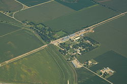
Fortescue is a village in southwestern Holt County, Missouri, United States. The population was 21 at the 2020 census. [4]
Fortescue was founded circa 1884. [5] An early railroad promoter named Fortesque gave the community the maiden name of his mother. [6] A post office called Fortescue was established in 1884, and remained in operation until 1973. [7]
According to the United States Census Bureau, the village has a total area of 0.08 square miles (0.21 km2), all land. [8] Fortescue is located 2.5 miles southeast of Big Lake, four miles southwest of Bigelow, and about 3.5 miles north of the Missouri, Kansas, and Nebraska trị-point. The village lies in the bottom lands of the Missouri River and is a few miles west of Loess Bluffs National Wildlife Refuge.
Census | Pop. | Note | %± |
---|---|---|---|
1920 | 153 | — | |
1930 | 141 | −7.8% | |
1940 | 175 | 24.1% | |
1950 | 117 | −33.1% | |
1960 | 78 | −33.3% | |
1970 | 63 | −19.2% | |
1980 | 51 | −19.0% | |
1990 | 46 | −9.8% | |
2000 | 51 | 10.9% | |
2010 | 32 | −37.3% | |
2020 | 21 | −34.4% | |
U.S. Decennial Census [9] |
As of the census [10] of 2010, there were 32 people, 10 households, and 9 families living in the village. The population density was 400.0 inhabitants per square mile (154.4/km2). There were 16 housing units at an average density of 200.0 per square mile (77.2/km2). The racial makeup of the village was 100.0% White.
There were 10 households, of which 40.0% had children under the age of 18 living with them, 80.0% were married couples living together, 10.0% had a male householder with no wife present, and 10.0% were non-families. 0.0% of all households were made up of individuals. The average household size was 3.20 and the average family size was 3.33.
The median age in the village was 31 years. 34.4% of residents were under the age of 18; 6.3% were between the ages of 18 and 24; 28.2% were from 25 to 44; 28.2% were from 45 to 64; and 3.1% were 65 years of age or older. The gender makeup of the village was 43.8% male and 56.3% female.
As of the census [3] of 2000, there were 51 people, 18 households, and 10 families living in the town. The population density was 674.1 inhabitants per square mile (260.3/km2). There were 23 housing units at an average density of 304.0 per square mile (117.4/km2). The racial makeup of the town was 100.00% White.
There were 18 households, out of which 61.1% had children under the age of 18 living with them, 44.4% were married couples living together, and 38.9% were non-families. 38.9% of all households were made up of individuals, and 11.1% had someone living alone who was 65 years of age or older. The average household size was 2.83 and the average family size was 3.82.
In the town the population was spread out, with 41.2% under the age of 18, 7.8% from 18 to 24, 35.3% from 25 to 44, 11.8% from 45 to 64, and 3.9% who were 65 years of age or older. The median age was 26 years. For every 100 females, there were 131.8 males. For every 100 females age 18 and over, there were 172.7 males.
The median income for a household in the town was $26,250, and the median income for a family was $28,125. Males had a median income of $33,125 versus $11,250 for females. The per capita income for the town was $5,695. There were 38.5% of families and 29.5% of the population living below the poverty line, including 21.4% of under eighteens and none of those over 64.
Miramiguoa Park is a village in Franklin County, Missouri, United States. The population was 120 at the 2010 census.
Parkway is a village in Franklin County, Missouri, United States. The population was 439 at the 2010 census.
Big Lake is a village in western Holt County, Missouri, United States. The population was 65 at the 2020 census.
Bigelow is a village in western Holt County, Missouri, United States. The population was 5 at the 2020 census.
River Bend is a village in Jackson County, Missouri, United States. The population was 3 at the 2020 census. It is the only part of Jackson County that lies north of the Missouri River. In 1951, the Missouri River was relocated to a new channel, creating River Bend,. The county line still follows the original riverbed. It is part of the Kansas City metropolitan area. The mayor is Alex Dockler.
Cedar Hill Lakes is a village in Jefferson County, Missouri, United States. The population was 203 at the 2020 census.
Evergreen is a village in Laclede County, Missouri, United States. The population was 28 at the 2010 census. It was named Twin Bridges at the 2000 census.
Cave is a City in Lincoln County, Missouri, United States. The population was 5 at the 2010 census. However, As of the 2020 census, the population is 0, making it the smallest incorporated community in the U.S state of Missouri. It is the 939th largest city in Missouri and the 19481st largest city in the United States. Cave is currently declining at a rate of 0.00% annually and its population has decreased by 0.00% since the most recent census, which recorded a population of 5 in 2010.
South Gifford is a village in Macon County, Missouri, United States. The population was 22 at the 2020 census, down from 50 in 2010.
Annada is a village in Pike County, Missouri, United States. The population was 29 at the 2010 census.
Roscoe is a village in St. Clair County, Missouri, United States. The population was 89 at the 2020 census.
Country Life Acres is a village in St. Louis County, Missouri, United States. The population was 72 at the 2020 census.
Glen Echo Park was a village in St. Louis County, Missouri, United States. The population was 122 at the 2020 census. The community took its name from the nearby Glen Echo Country Club.
Grantwood Village is a town in St. Louis County, Missouri, United States. The population was 863 at the 2010 census.
Marlborough is a village in St. Louis County, Missouri, United States. The population was 2,179 at the 2010 census.
Sycamore Hills is a village in St. Louis County, Missouri, United States. The population is 560 at the 2020 census.
Westwood is a village in west St. Louis County, Missouri, United States. The population was 316 at the 2020 census.
Penermon is a village in Stoddard County, Missouri, United States. The population was 64 at the 2010 census.
Champ is a village in St. Louis County, Missouri, United States. The population was 10 at the 2020 census.
Hanley Hills is a village in St. Louis County, Missouri, United States. The population was 2,101 at the 2010 census.
{{cite web}}
: CS1 maint: bot: original URL status unknown (link)