
Dunton is a village and civil parish in the Aylesbury Vale district of Buckinghamshire, England. The village is situated approximately 8 miles (13 km) north from Aylesbury and 4 miles (6.4 km) south-east from Winslow.

East Farndon is a small linear village and civil parish about one mile south of Market Harborough in West Northamptonshire, England. The village is close to the border with Leicestershire, and has a Leicestershire post code and telephone dialling code. At the time of the 2001 census, the parish's population was 258 people, increasing to 307 at the 2011 census.

West Overton is a village and civil parish in the English county of Wiltshire, about 3.5 miles (5.6 km) west of Marlborough. The river Kennet runs immediately north of the village, separating it from the A4 road. The parish includes the village of Lockeridge, also near the river, further east (downstream).

Tidmarsh is a village in West Berkshire, England. Its development is mainly residential and agricultural, and is centred on the A340 road between Pangbourne and Theale. The rural area is bounded by the M4 motorway to the south. It is centred 1.5 miles (2.4 km) south of Pangbourne, 5.5 miles (8.9 km) west of Reading and 40 miles (64 km) west of London.

Ashford-in-the-Water is a village and civil parish in the Derbyshire Peak District, England. The village is on the River Wye, 2 miles (3 km) north-west of Bakewell. It is known for the quarrying of Ashford Black Marble, and for the maidens' garlands made to mark the deaths of virgins in the village until 1801. Some of these are preserved in the parish church. The civil parish population taken at the 2011 Census was 559.

Bylaugh is a civil parish in Norfolk, England 4.5 miles (7.2 km) north-east of East Dereham and 13.5 miles (21.7 km) WNW of Norwich. For the purposes of local government it falls within the Upper Wensum Ward of Breckland District Council and the Elmham and Mattishall Division of Norfolk County Council. According to the 2001 census it had a population of 65. At the 2011 census the population remained less than 100 and was included in the civil parish of Sparham.

Stapleford Abbotts is a village and civil parish in the Epping Forest district of Essex, approximately 5.5 mi (9 km) SW of Ongar, 4.5 mi (7 km) N of Romford and 5 mi (8 km) SSE of Epping. The whole parish is within the M25 motorway. The village covers 957 hectares and had a population of 959 in 2001, increasing to 1,008 at the 2011 Census.

Rode is a village and civil parish in the ceremonial county of Somerset in England, 5 miles (8.0 km) north-east of Frome and 5 miles (8.0 km) south-west of Trowbridge.

Warnham is a village and civil parish in the Horsham district of West Sussex, England. The village is centred 2 miles (3.2 km) north-northwest of Horsham, 31 miles (50 km) from London, to the west of the A24 road. The parish is in the north-west of the Weald.

Milton Lilbourne is a village and civil parish in the county of Wiltshire, England, in the Vale of Pewsey between Pewsey and Burbage. It is largely a mixed residential area centred on the Manor. The nearest town is Marlborough, 5.5 miles (8.9 km) to the north.

Marcham is a village and civil parish about 2 miles (3 km) west of Abingdon, Oxfordshire. The 2011 Census recorded the parish's population as 1,905. The parish includes the hamlets of Cothill 1+3⁄4 miles (2.8 km) east-northeast of the village, and Gozzard's Ford 1+1⁄2 miles (2.4 km) northeast of the village. Frilford and Garford used to be townships of Marcham parish, but are now separate civil parishes. All these parishes were part of Berkshire until the 1974 boundary changes transferred them to Oxfordshire.

Stanford Rivers is a village and civil parish in the Epping Forest district of Essex, England. The parish, which is approximately 11 miles (18 km) west from the county town of Chelmsford, contains the village of Toot Hill and the hamlet of Little End, both settlements larger than Stanford Rivers village, and the hamlet of Clatterford End. The village is 2.0 miles (3 km) south-east of Chipping Ongar, 3 miles (5 km) south-west of North Weald Bassett and 3 miles north-west of Kelvedon Hatch. The parish covers an area of 1,749 hectares.

Matching is a village and civil parish in the Epping Forest district of Essex, England centred in countryside 3 miles (4.8 km) east of Harlow's modern town centre and 2 miles (3.2 km) from Old Harlow/Harlow Mills area of the town. The terrain is elevated and London is centred 21.7 miles (34.9 km) to the south-west.

Garford is a village and civil parish about 4 miles (6.4 km) west of Abingdon. It was part of Berkshire until the 1974 boundary changes transferred it to Oxfordshire. The parish is bounded by the River Ock to the north, by two tributaries of the Ock to the south, and by field boundaries and the road between Kingston Bagpuize and West Hanney to the west. The 2011 Census recorded the parish's population as 229.
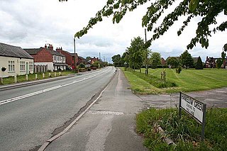
Hankelow is a village and civil parish in the unitary authority of Cheshire East and the ceremonial county of Cheshire, England. The village lies on the A529, around 1.25 miles (2.0 km) north east of Audlem and 4.5 miles (7.2 km) south of Nantwich. The civil parish has an area 369 hectares and also includes the small settlement of The Dell and part of Corbrook, with a total population of just over 260 in 2011. Nearby villages include Aston, Broomhall Green, Sound, Hatherton and Buerton in Cheshire and Woore in Shropshire.
Crawley is a village and civil parish beside the River Windrush about 2+1⁄2 miles (4 km) north of Witney, Oxfordshire. The parish extends from the Windrush in the south almost to village of Leafield in the northwest. The 2011 Census recorded the parish's population as 155.
Shelley is a partly rural village and partly residential conurbation in the Ongar civil parish of the Epping Forest district of Essex, England.
High Easter is a village and a civil parish in the Uttlesford district of Essex, England.

Epping Upland, formerly just Epping is a village and civil parish in the Epping Forest district of Essex, England.

Newton on Trent is a village and civil parish in the West Lindsey district of Lincolnshire, England. The population of the civil parish at the 2011 census was 389. The village is situated east of the River Trent, and is 10 miles (16 km) south of Gainsborough, 10 miles (16 km) west of Lincoln, and at the junction of the A57 running east to west, and the A1133 running north to south.

