Garrison, Texas | |
---|---|
Coordinates: 31°49′40″N94°29′52″W / 31.82778°N 94.49778°W | |
Country | United States |
State | Texas |
County | Nacogdoches |
Area | |
• Total | 1.17 sq mi (3.04 km2) |
• Land | 1.17 sq mi (3.04 km2) |
• Water | 0.00 sq mi (0.00 km2) |
Elevation | 397 ft (121 m) |
Population (2020) | |
• Total | 789 |
• Density | 743.61/sq mi (287.14/km2) |
Time zone | UTC-6 (Central (CST)) |
• Summer (DST) | UTC-5 (CDT) |
ZIP code | 75946 |
Area code | 936 |
FIPS code | 48-29060 [3] |
GNIS feature ID | 2410574 [2] |
Website | www |
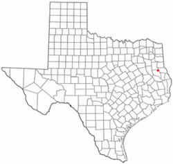
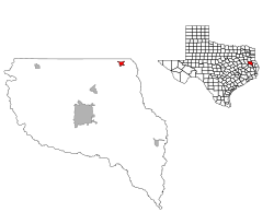
Garrison is a small town in Nacogdoches County, Texas, United States. The population was 789 at the 2020 census.
Garrison may be named for an early settler, Captain Zadock Bonner "Zed" Garrison (April 20, 1829 – January 9, 1909). Captain Garrison served as a First Lieutenant in the First Regiment, Texas Mounted Volunteers during the Civil War. [4]
According to the United States Census Bureau, the city has a total area of 1.2 square miles (3.1 km2), all land.
Census | Pop. | Note | %± |
---|---|---|---|
1890 | 252 | — | |
1900 | 530 | 110.3% | |
1910 | 627 | 18.3% | |
1920 | 603 | −3.8% | |
1930 | 527 | −12.6% | |
1940 | 770 | 46.1% | |
1950 | 699 | −9.2% | |
1960 | 951 | 36.1% | |
1970 | 1,082 | 13.8% | |
1980 | 1,059 | −2.1% | |
1990 | 883 | −16.6% | |
2000 | 844 | −4.4% | |
2010 | 895 | 6.0% | |
2020 | 789 | −11.8% | |
U.S. Decennial Census [5] |
Race | Number | Percentage |
---|---|---|
White (NH) | 468 | 59.32% |
Black or African American (NH) | 195 | 24.71% |
Asian (NH) | 4 | 0.51% |
Mixed/Multi-Racial (NH) | 42 | 5.32% |
Hispanic or Latino | 80 | 10.14% |
Total | 789 |
As of the 2020 United States census, there were 789 people, 446 households, and 343 families residing in the city.
As of 2010 Garrison had a population of 895. The median age was 38. The racial makeup of the population was 67.4% white, 24.8% black or African American, 1.3% Asian, 4.7% from some other race and 1.8% from two or more races. 9.3% of the population was Hispanic or Latino of any race. [9]
As of the census [3] of 2000, there were 844 people, 312 households, and 218 families residing in the city. The population density was 727.4 inhabitants per square mile (280.9/km2). There were 372 housing units at an average density of 320.6 per square mile (123.8/km2). The racial makeup of the city was 67.54% White, 29.03% African American, 0.71% Native American, 0.24% Asian, 1.18% from other races, and 1.30% from two or more races. Hispanic or Latino of any race were 3.32% of the population.
There were 312 households, out of which 32.7% had children under the age of 18 living with them, 45.8% were married couples living together, 20.5% had a female householder with no husband present, and 30.1% were non-families. 26.0% of all households were made up of individuals, and 17.9% had someone living alone who was 65 years of age or older. The average household size was 2.57 and the average family size was 3.10.
In the city, the population was spread out, with 28.8% under the age of 18, 7.8% from 18 to 24, 22.9% from 25 to 44, 17.1% from 45 to 64, and 23.5% who were 65 years of age or older. The median age was 38 years. For every 100 females, there were 85.9 males. For every 100 females age 18 and over, there were 76.8 males.
The median income for a household in the city was $20,278, and the median income for a family was $27,639. Males had a median income of $28,654 versus $22,143 for females. The per capita income for the city was $12,222. About 19.1% of families and 20.6% of the population were below the poverty line, including 21.5% of those under age 18 and 20.3% of those age 65 or over.
Garrison is served by the Garrison Independent School District and is home to the Garrison Bulldogs.
Sunnyside–Tahoe City is a census-designated place (CDP) in Placer County, California, located on the northwest shore of Lake Tahoe. The population was 1,557 at the 2010 census, down from 1,761 at the 2000 census, and a total area of 3.4 sq mi (8.8 km2), all of it land. It includes the two communities, Sunnyside, and Tahoe City.
Grandview Plaza is a city in Geary County, Kansas, United States. As of the 2020 census, the population of the city was 1,697.
Cimarron is a city in and the county seat of Gray County, Kansas, United States. As of the 2020 census, the population of the city was 1,981. It is located along Highway 50.
Meade is a city in and the county seat of Meade County, Kansas, United States. As of the 2020 census, the population of the city was 1,505.
Ness City is a city in and the county seat of Ness County, Kansas, United States. As of the 2020 census, the population of the city was 1,329. Ness City is famous for its four-story Old Ness County Bank Building located downtown and nicknamed Skyscraper of the Plains.
Andale is a city in Sedgwick County, Kansas, United States. As of the 2020 census, the population of the city was 941.
Colwich is a city in Sedgwick County, Kansas, United States, located northwest of Wichita. As of the 2020 census, the population of the city was 1,455.
Mount Hope is a city in Sedgwick County, Kansas, United States. As of the 2020 census, the population of the city was 806.
Lyons is a village in Ionia County in the U.S. state of Michigan. The population was 789 at the 2010 census. Most of the village is within Lyons Township. A small portion extends west into Ionia Township.
Country Club Hills is a city in St. Louis County, Missouri, United States. The population was 1,274 at the 2010 census.
Flordell Hills is a city in St. Louis County, Missouri, United States. The population was 822 at the 2010 census.
Northwoods is a city in St. Louis County, Missouri, United States. The population was 4,227 at the 2010 census.
Velda City is a city in St. Louis County, Missouri, United States. The population was 1,420 at the 2010 census.
Moline Acres is a city in St. Louis County, Missouri, United States. The population was 2,442 at the 2010 census.
Mertzon is a city in and the county seat of Irion County, Texas, United States. Its population was 747 according to the 2020 census. It is part of the San Angleo, metropolitan statistical area.
Beverly Hills is a city in McLennan County, Texas, United States. The population was 1,878 at the 2020 census. The city is surrounded by Waco and is part of the Waco Metropolitan Statistical Area.
Pineland is a city in Sabine County, Texas, United States. The population was 888 at the 2020 census.
Aspermont is a town and the county seat of Stonewall County, Texas, United States. The population was 789 at the 2020 census.
Stonewood is a city in Harrison County, West Virginia, United States. The population was 1,810 at the 2020 census.
Josephine is a city in Collin and Hunt Counties in the U.S. state of Texas. The population was 2,119 at the 2020 census, and according to 2023 census estimates, the city is estimated to have a population of 7,113.