Gasconade, Missouri | |
---|---|
Coordinates: 38°40′13″N91°33′36″W / 38.67028°N 91.56000°W Coordinates: 38°40′13″N91°33′36″W / 38.67028°N 91.56000°W | |
Country | United States |
State | Missouri |
County | Gasconade |
Area | |
• Total | 0.20 sq mi (0.53 km2) |
• Land | 0.20 sq mi (0.53 km2) |
• Water | 0.00 sq mi (0.00 km2) |
Elevation | 528 ft (161 m) |
Population | |
• Total | 172 |
• Density | 847.29/sq mi (327.22/km2) |
Time zone | UTC-6 (Central (CST)) |
• Summer (DST) | UTC-5 (CDT) |
ZIP codes | 65036, 65061 |
Area code | 573 |
FIPS code | 29-26578 [4] |
GNIS feature ID | 2394867 [2] |
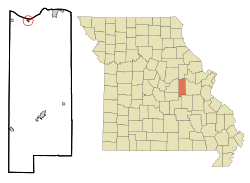
Gasconade is a city in Gasconade County, Missouri. The population is 172 as of the 2020 census. [5]
Gasconade was platted in 1857. It is situated at the mouth of the Gasconade River, from which it takes its name. [6]
The Gasconade Bridge train disaster was a rail accident that took place in Gasconade on November 1, 1855, when the Gasconade bridge collapsed under the weight of the O'Sullivan locomotive. Thirty-one people were killed. [7]
According to the United States Census Bureau, the city has a total area of 0.20 square miles (0.52 km2), all land. [8]
Census | Pop. | Note | %± |
---|---|---|---|
1930 | 375 | — | |
1940 | 494 | 31.7% | |
1950 | 448 | −9.3% | |
1960 | 333 | −25.7% | |
1970 | 235 | −29.4% | |
1980 | 250 | 6.4% | |
1990 | 253 | 1.2% | |
2000 | 267 | 5.5% | |
2010 | 223 | −16.5% | |
2020 | 172 | −22.9% | |
U.S. Decennial Census [9] [3] |
As of the census [10] of 2010, there were 223 people, 97 households, and 57 families residing in the city. The population density was 1,115.0 inhabitants per square mile (430.5/km2). There were 138 housing units at an average density of 690.0 per square mile (266.4/km2). The racial makeup of the city was 99.1% White, 0.4% African American, and 0.4% from two or more races.
There were 97 households, of which 23.7% had children under the age of 18 living with them, 38.1% were married couples living together, 14.4% had a female householder with no husband present, 6.2% had a male householder with no wife present, and 41.2% were non-families. 33.0% of all households were made up of individuals, and 21.6% had someone living alone who was 65 years of age or older. The average household size was 2.30 and the average family size was 2.89.
The median age in the city was 46.3 years. 23.3% of residents were under the age of 18; 5.7% were between the ages of 18 and 24; 17.9% were from 25 to 44; 29.2% were from 45 to 64; and 23.8% were 65 years of age or older. The gender makeup of the city was 47.5% male and 52.5% female.
As of the census [4] of 2000, there were 267 people, 105 households, and 72 families residing in the city. The population density was 1,280.5 inhabitants per square mile (494.4/km2). There were 141 housing units at an average density of 676.2 per square mile (261.1/km2). The racial makeup of the city was 96.63% White, 0.75% Native American, 1.12% Asian, and 1.50% from two or more races.
There were 105 households, out of which 23.8% had children under the age of 18 living with them, 47.6% were married couples living together, 16.2% had a female householder with no husband present, and 31.4% were non-families. 28.6% of all households were made up of individuals, and 17.1% had someone living alone who was 65 years of age or older. The average household size was 2.54 and the average family size was 3.04.
In the city the population was spread out, with 26.6% under the age of 18, 7.5% from 18 to 24, 22.8% from 25 to 44, 22.8% from 45 to 64, and 20.2% who were 65 years of age or older. The median age was 39 years. For every 100 females, there were 81.6 males. For every 100 females age 18 and over, there were 78.2 males.
The median income for a household in the city was $27,404, and the median income for a family was $27,917. Males had a median income of $22,045 versus $18,594 for females. The per capita income for the city was $13,131. About 19.7% of families and 25.4% of the population were below the poverty line, including 40.5% of those under the age of eighteen and 13.7% of those 65 or over.
Mosby is a city in Clay County, Missouri, United States, along the Fishing River. The population was 101 at the 2020 census. It is part of the Kansas City metropolitan area.
Gerald is a city in western Franklin County, Missouri, United States. The population was 1,345 at the 2010 census.
Hermann is a city in and the county seat of Gasconade County, Missouri, United States. It has been the county seat since 1842. It is near the center of the Missouri Rhineland and south of the Missouri River. The population was 2,185 at the 2020 census.
Morrison is a city in Gasconade County, Missouri, United States. The first permanent settlement in the town was made by Robert Shobe circa 1828. The population was 93 at the 2020 census.
Owensville is a city in Gasconade County, Missouri, United States. The population was 2,757 at the 2020 census.
Rosebud is a city in Gasconade County, Missouri, United States. The population was 390 at the 2020 census.
Calhoun is a city in Henry County, Missouri, United States. The population was 469 at the 2010 census.
Vienna is a city in and the county seat of Maries County, Missouri, United States. Its population was 581 at the 2020 census.
Linn is a city in Osage County, Missouri, United States. The population was 1,350 at the 2020 census. It is the county seat of Osage County. Linn is part of the Jefferson City, Missouri Metropolitan Statistical Area.
Westphalia is a city in Osage County, Missouri, United States. The population was 378 at the 2020 census. It is part of the Jefferson City, Missouri Metropolitan Statistical Area.
Hayti Heights is a city in eastern Pemiscot County in the bootheel of southeast Missouri, United States. The population was 515 at the 2020 census.
Northwoods is a city in St. Louis County, Missouri, United States. The population was 4,227 at the 2010 census.
Velda City is a city in St. Louis County, Missouri, United States. The population was 1,420 at the 2010 census.
Dudley is a city in Stoddard County, Missouri, United States. The population was 232 at the 2010 census.
Hartville is a city in Wright County, Missouri, United States. The population was 594 at the 2020 census. It is the county seat of Wright County.
Clarkson Valley is a city in St. Louis County, Missouri, United States. The population was 2,609 at the 2020 census.
Stoutland is a village in Camden and Laclede counties in the U.S. state of Missouri. The population was 192 at the 2010 census.
Bland is a city in Gasconade and Osage counties in the U.S. state of Missouri. The population was 506 at the 2020 census.
Blackburn is a city in Lafayette and Saline counties in the U.S. state of Missouri and is part of the Kansas City metropolitan area. The population was 249 at the 2010 census.
Belle is a city in northeast Maries County and extending north into southeast Osage County in the U.S. state of Missouri. The population was 1,381 at the 2020 census.