Councils of Tasmania are the 29 administrative districts of the Australian state of Tasmania. Local government areas (LGAs), more generally known as councils, are the tier of government responsible for the management of local duties such as road maintenance, town planning and waste management.

The Brooker Highway is a highway in the Australian state of Tasmania. As one of Hobart's three major radials, the highway connects traffic from the city centre with the northern suburbs and is the major road connection to the cities and towns of northern Tasmania. With an annual average daily traffic of 48,000, the highway is one of the busiest in Tasmania. The Brooker Highway has recently been declared part of the National Highway.

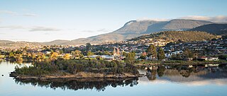
Glenorchy City Council is a local government body in Tasmania, and one of the five municipalities that constitutes the Greater Hobart Area. The Glenorchy local government area has a population of 50,411, covering the suburbs north of central Hobart on the western shore of the Derwent River, including its namesake suburb, Glenorchy.
Claremont is a rural / residential locality in the local government areas (LGA) of Glenorchy (75%) and Derwent Valley (25%) in the Hobart and South-east LGA regions of Tasmania. The locality is about 6 kilometres (3.7 mi) north of the town of Glenorchy. The 2021 census recorded a population of 8,397 for the state suburb of Claremont.

Moonah is a residential locality in the local government area (LGA) of Glenorchy in the Hobart LGA region of Tasmania. The locality is about 3 kilometres (1.9 mi) south-east of the town of Glenorchy. The 2016 census recorded a population of 5421 for the state suburb of Moonah. It is a suburb in the city of Hobart, located approximately 5 km north of the central business district of Hobart, and lying directly north of the inner city suburb New Town.

Geilston Bay is a largely residential suburb of Hobart between Risdon Vale, Shag Bay, and Lindisfarne, in the City of Clarence located on the Eastern Shore of the Derwent River, taking its name from an inlet of that river of the same name. The inlet and locality were sometimes known by the alternative name "Limekiln Bay" on account of lime kilns which operated there between approximately the 1830s and the 1920s, the remains of which remained visible for some decades thereafter; another early name for the Bay was "James's Bay". The present suburb name derives from an early land holding "Geils Town" in the region purchased by Andrew Geils, Commandant of Van Diemen's Land (Tasmania) for a brief period in 1812-1813, who subsequently left his Australian holdings behind when he moved back to Scotland.
Chigwell is a residential locality in the local government area (LGA) of Glenorchy in the Hobart LGA region of Tasmania. The locality is about 6 kilometres (3.7 mi) north-west of the town of Glenorchy. The 2016 census recorded a population of 2002 for the state suburb of Chigwell.

Berriedale is a suburb in the northern suburbs of Hobart, capital of Tasmania, Australia. It is in the local government area of City of Glenorchy. The suburb is situated between the suburbs of Chigwell and Rosetta. The suburb is generally known for the Museum of Old and New Art and Moorilla Estate.
Rosetta is a residential suburb about 3 kilometres (1.9 mi) northwest of Glenorchy, located in local government area (LGA) of City of Glenorchy. In the 2021 census, Rosetta had a population of 2,833. This suburb is part of the Hobart LGA Region, nestled between Berriedale and Montrose and roughly a 15-minute drive from Hobart. Rosetta features a primary school and a high school and is bordered by the Brooker Highway along the east, adjacent to the Derwent River.

Montrose is a residential locality in the local government area (LGA) of Glenorchy in the Hobart LGA region of Tasmania. The locality is about 1 kilometre (0.62 mi) north of the town of Glenorchy. The 2016 census recorded a population of 2152 for the state suburb of Montrose. It is a suburb of Hobart. The suburb is situated in close proximity with Rosetta. Montrose is the suburb directly north of Glenorchy. It is also in Montrose where the Montrose Foreshore Community Park is located.

West Moonah is a residential suburb of Hobart, Tasmania, Australia. It is part of the City of Glenorchy local government area, with about 5% being in the Hobart LGA. At the 2016 Australian census, the suburb recorded a population of approximately 1,000.

Derwent Park is a residential locality in the local government area (LGA) of Glenorchy in the Hobart LGA region of Tasmania. The locality is about 2 kilometres (1.2 mi) east of the town of Glenorchy. The 2016 census recorded a population of 657 for the state suburb of Derwent Park. It is a suburb of Hobart.
Goodwood is a residential locality in the local government area (LGA) of Glenorchy in the Hobart LGA region of Tasmania. The locality is about 2 kilometres (1.2 mi) east of the town of Glenorchy. The 2016 census recorded a population of 1049 for the state suburb of Goodwood. It is a suburb of Hobart.

Lutana is a residential locality in the local government area (LGA) of Glenorchy in the Hobart LGA region of Tasmania. The locality is about 3 kilometres (1.9 mi) south-east of the town of Glenorchy. The 2021 census recorded a population of 2,616 for the state suburb of Lutana. It is a suburb of Hobart. It is a large residential suburb located between the Brooker Highway and the River Derwent.
Dowsing Point is a residential locality in the local government area (LGA) of Glenorchy in the Hobart LGA region of Tasmania. The locality is about 2 kilometres (1.2 mi) north-east of the town of Glenorchy. The 2016 census recorded a population of 85 for the state suburb of Dowsing Point.

Rose Bay is a suburb of the City of Clarence in greater Hobart, capital city of Tasmania, Australia. Rose Bay is a small suburb, making up only approximately 0.9 square kilometres with nearly one fourth of that area (23.2%) being parkland. At the 2016 Census the suburb recorded a population of 1,102 people.

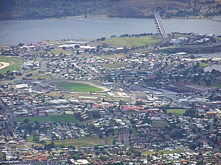
Elwick Racecourse is a Thoroughbred horse-racing venue located on Goodwood Road within Glenorchy, Tasmania, Australia. It is located in close proximity to the Brooker Highway, Hobart Showground, Derwent Entertainment Centre, Glenorchy Art and Sculpture Park and the River Derwent. The Racecourse has a picturesque outlook across the river, as well as being dominated by views of kunanyi / Mount Wellington. Elwick features at least 110 race meetings and 210 trial days a year, but is most well known for hosting the Hobart Cup.

Goodwood Road is a 4-lane link road that connects the City of Glenorchy to the City of Clarence in the greater area of Hobart, Tasmania. Using the Bowen Bridge the road travels over the River Derwent in semi-highway road layout. The road starts 10 km north of the Hobart CBD near the Hobart Showground on the Brooker Highway at Glenorchy, from there it travels east past the Elwick Racecourse, over the Bowen Bridge and connects to the East Derwent Highway at Otago. While the route the road takes is used far less than other major arterial roads in Hobart, commuters often depend on the road when major incidents occur on other major roads throughout Hobart.
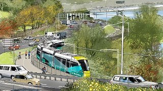
Riverline, also known as the Northern Suburbs Railway, is a proposed light rail system that would traverse the southernmost section of the South Railway Line, through the northern suburbs of Hobart, Tasmania.

The Glenorchy Art and Sculpture Park (GASP) is a sculpture park and boardwalk in Glenorchy, Tasmania, Australia. Commencing at Montrose Foreshore Community Park, GASP follows Elwick Bay's foreshore, terminating at Wilkinsons Point. GASP is in close proximity to the MyState Bank Arena, Elwick Racecourse and the Museum of Old and New Art (MONA) in Berriedale.


