
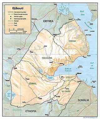
Djibouti is a country in the Horn of Africa. It is bordered by Eritrea in the north, Ethiopia in the west and south, and Somalia in the southeast. To the east is its coastline on the Red Sea and the Gulf of Aden. Rainfall is sparse, and most of the territory has a semi-arid to arid environment. Lake Assal is a saline lake which lies 155 m (509 ft) below sea level, making it the lowest point on land in Africa and the third-lowest point on Earth after the Sea of Galilee and the Dead Sea. Djibouti has the fifth smallest population in Africa. Djibouti's major settlements include the capital Djibouti City, the port towns of Tadjoura and Obock, and the southern cities of Ali Sabieh and Dikhil. It is the forty-six country by area in Africa and 147st largest country in the world by land area, covering a total of 23,200 km2 (9,000 sq mi), of which 23,180 km2 (8,950 sq mi) is land and 20 km2 (7.7 sq mi) is water.
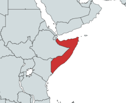
Somalia is a country located in the Horn of Africa which officially consists of the intra-46th meridian east territory, the seven federal member states, namely Galmudug, Hirshabelle, Jubaland, South West, Puntland, and the municipality of Benadir. It is bordered by Ethiopia to the west, the Gulf of Aden to the north, the Somali Sea and Guardafui Channel to the east, and Kenya to the southwest. With a land area of 637,657 square kilometers, Somalia's terrain consists mainly of plateaus, plains and highlands. Its coastline is more than 3,333 kilometers in length, the longest of mainland Africa. It has been described as being roughly shaped "like a tilted number seven".

The Arabian Desert is a vast desert wilderness in West Asia that occupies almost the entire Arabian Peninsula with an area of 2,330,000 square kilometers (900,000 sq mi). It stretches from Yemen to the Persian Gulf and Oman to Jordan and Iraq. It is the fourth largest desert in the world and the largest in Asia. At its center is Ar-Rub' al-Khali, one of the largest continuous bodies of sand in the world. It is an extension of the Sahara Desert.

Oryx is a genus consisting of four large antelope species called oryxes. Their pelage is pale with contrasting dark markings in the face and on the legs, and their long horns are almost straight. The exception is the scimitar oryx, which lacks dark markings on the legs, only has faint dark markings on the head, has an ochre neck, and has horns that are clearly decurved.

The antilopines are even-toed ungulates belonging to the subfamily Antilopinae of the family Bovidae. The members of tribe Antilopini are often referred to as true antelopes, and include the gazelles, blackbucks, springboks, gerenuks, dibatags, and Central Asian gazelles. True antelopes occur in much of Africa and Asia, with the highest concentration of species occurring in East Africa in Sudan, Eritrea, Ethiopia, Somalia, Kenya, and Tanzania. The saiga inhabits Central and Western Asia, mostly in regions from the Tibetan Plateau and north of the Indian Subcontinent. The dwarf antelope species of tribe Neotragini live entirely in sub-Saharan Africa.

The East Saharan montane xeric woodlands is an ecoregion of central Africa, a number of high mountains in the middle of the huge area of savanna on the edge of the Sahara Desert.

The gemsbok, or South African oryx, is a large antelope in the genus Oryx. It is endemic to the dry and barren regions of Botswana, Namibia, South Africa and Zimbabwe, mainly inhabiting the Kalahari and Namib Deserts, areas in which it is supremely adapted for survival. Previously, some sources classified the related East African oryx, or beisa oryx, as a subspecies.

The Arabian gazelle(Gazella arabica) is a species of gazelle from the Arabian Peninsula. There are approximately 5,000 – 7,000 mature individuals in the wild.
The wildlife of Djibouti, consisting of its flora and fauna, is in a harsh landscape with forest accounting for less than one percent of its area. Most species are found in the northern part of the country in the Day Forest National Park at an average elevation of 1,500 metres (4,900 ft), including the massif Goda, with a peak of 1,783 metres (5,850 ft). It covers an area of 3.5 square kilometres (1.4 sq mi) of Juniperus procera forest, with many of the trees rising to 20 metres (66 ft) height. This forest area is the main habitat of the critically endangered and endemic Djibouti spurfowl, and another recently noted vertebrate, Platyceps afarensis. The area also contains many species of woody and herbaceous plants, including boxwood and olive trees, which account for sixty percent of the identified species in the country.

The North Saharan steppe and woodlands is a desert ecoregion, in the deserts and xeric shrublands biome, that forms the northern edge of the Sahara. It extends east and west across Northern Africa, south of the Mediterranean dry woodlands and steppe ecoregion of the Maghreb and Cyrenaica, which is part of the Mediterranean forests, woodlands, and scrub biome. Winter rains sustain shrublands and dry woodlands that form an ecotone between the Mediterranean climate regions to the north and the hyper-arid Sahara Desert ecoregion to the south.

The South Saharan steppe and woodlands, also known as the South Sahara desert, is a deserts and xeric shrublands ecoregion of northern Africa. This band is a transitional region between the Sahara's very arid center to the north, and the wetter Sahelian Acacia savanna ecoregion to the south. In pre-modern times, the grasslands were grazed by migratory gazelles and other ungulates after the rainfalls. More recently, over-grazing by domestic livestock have degraded the territory. Despite the name of the ecoregion, there are few 'woodlands' in the area; those that exist are generally acacia and shrubs along rivers and in wadis.

The Tibesti-Jebel Uweinat montane xeric woodlands is a deserts and xeric shrublands ecoregion in the eastern Sahara. The woodlands ecoregion occupies two separate highland regions, covering portions of northern Chad, southwestern Egypt, southern Libya, and northwestern Sudan.
The Eritrean coastal desert ecoregion is a harsh sand and gravel strip along the southern part of the coast of Eritrea and the Red Sea coast of Djibouti. This coast is of ecological importance as a channel for the mass migration of birds of prey.

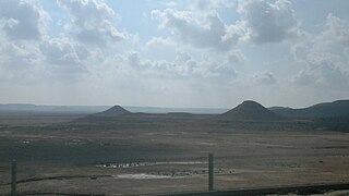
The Djibouti xeric shrublands is an ecoregion defined by One Earth, consisting of a semi-desert strip on or near the Red Sea and the Gulf of Aden coasts in Eritrea, Ethiopia, Djibouti and Somalia. This ecoregion lies mainly between sea level and 800 meters (m) elevation. There are, however, many hills and massifs, which range up to 1300 m as well as outstanding fault-induced depressions, such as the Danakil, lying as low as 155 m below sea level. This region is extremely active tectonically, experiencing many earthquakes and intermittently active volcanoes. Rainfall is very low and yearly averages range from 100 to 200 millimeters (mm), with less rain falling closer to the coast. There are many species of interest, including the endemic Archer's lark, a species of dragon tree, and a large suite of desert ungulates, including the last viable population of African wild ass.

The Hobyo grasslands and shrublands is a desert and xeric scrubland ecoregion in Somalia. The ecoregion includes a belt of coastal dunes, 10 to 15 km wide, along the Indian Ocean coast, extending from north of Hobyo to south of Mogadishu.
The Northern Acacia–Commiphora bushlands and thickets are a tropical grasslands, savannas and shrublands ecoregion in eastern Africa. The ecoregion is mostly located in Kenya, extending north into southeastern South Sudan, northeastern Uganda and southwestern Ethiopia and south into Tanzania along the Kenya-Tanzania border.

The Somali Acacia–Commiphora bushlands and thickets is a semi-arid tropical grasslands, savannas, and shrublands ecoregion in the Horn of Africa. It is home to diverse communities of plants and animals, including several endemic species.

The Somali montane xeric shrublands is a desert and xeric scrubland ecoregion in Somalia. The ecoregion lies in the rugged Karkaar Mountains, which run parallel and close to Somalia's northern coast on the Gulf of Aden, and follows coast from Cape Guardafui south to Eyl on the Arabian Sea.

The Namibian savanna woodlands, also known as the Namib escarpment woodlands, are the deserts and xeric shrublands ecoregion of Namibia and Angola.
The Mesopotamian shrub desert is a deserts and xeric shrublands ecoregion in Western Asia. It extends across portions of Israel, Jordan, Syria, Iraq, and Iran.
