Grand Parade (Halifax)

Last updated
Grand Parade
Public square
Halifax Grand Parade.jpg
Grand Parade viewed from City Hall
FeaturesCenotaph, flagpole
Opening date1749
Area0.6 hectares (1.5 acres) (approx)
SurfaceGrass, brick
Location Halifax, Nova Scotia

The Grand Parade (sometimes incorrectly referred to as "Parade Square") is an historic military parade square dating from the founding of Halifax in 1749. At the north end of the Grand Parade is the Halifax City Hall, the seat of municipal government in Nova Scotia's Halifax Regional Municipality. At the south end is St. Paul's Church. In the middle of Grand Parade is the cenotaph built originally to commemorate the soldiers who served in World War I.

Contents

Centrally located in Downtown Halifax, the square remains an important civic space used for numerous events including musical performances, political demonstrations, the annual New Year's Eve celebrations, Remembrance Day ceremonies, and Christmas tree lighting.

History

Halifax town plan with Grand Parade at centre A Plan of the Town of Halifax in Nova Scotia 1749.gif
Halifax town plan with Grand Parade at centre

18th century

The first contingent of British settlers in Halifax arrived in June 1749 and completed 300 houses by October 1749. Lieutenant John Brewse, a military engineer, sited the town within a defensive perimeter while Charles Morris, appointed Chief Surveyor on 25 September 1749, worked on the town layout and probably conducted the actual surveying. [1] Moses Harris, a settler skilled in draughting, published the town plan for Halifax in 1749. It comprised an urban grid made up of oblong, rectangular city blocks with the Grand Parade at the centre of the town. The plan stipulated a church at one end of the square (opened 1750), and a courthouse and prison at the northern end. However, the north end remained vacant. [1]

Shortly after arriving in Halifax, Governor Cornwallis ordered framing from Boston for the construction of a church. The cornerstone for the church was laid on 13 June 1750. It was named St. Paul's in 1759 when a parish of that name was established. [1] The building was modeled off Marybone Chapel in London. [1]

In 1794 Prince Edward arrived in Halifax to command the military in Nova Scotia and New Brunswick. He set about improving the military facilities around the city, and had the Grand Parade leveled to improve its usefulness. As Barrington Street slopes down toward the north of Grand Parade, a retaining wall was built here to keep the square level. The retaining wall is tall enough to accommodate inhabitable space underneath the square, with frontage on Barrington. This space originally accommodated ice houses for Mrs. Jane Donaldson, a Granville Street merchant. [1]

19th century

Dalhousie Square. A winter scene depicting men and women in their sleighs in front of Dalhousie College, Halifax, Nova Scotia, 1851. Dalhousie Square, Halifax, Nova Scotia.jpg
Dalhousie Square. A winter scene depicting men and women in their sleighs in front of Dalhousie College, Halifax, Nova Scotia, 1851.
Dalhousie College Halifax Canada 1871.jpg
Dalhousie College in 1871, where City Hall now stands
Halifax - NS - Rathaus Halifax.jpg
Halifax City Hall, opened 1890

The original building of Dalhousie College (now Dalhousie University) opened at the north end of the Grand Parade in 1821. It was a Georgian four storey building separated from the square by a dry moat to allow light to the lower floors. [1] As the 19th century progressed the Grand Parade deteriorated. Dalhousie claimed to lack the funds to upkeep the space while the city claimed it could not take responsibility for the square without undisputed ownership of it. [1] Meanwhile, city offices and council chambers were located at premises on Water Street described at the time as "a trifle porous", "disreputable looking", and "a dirty hole". [1] In 1872 the council asked E.H. Keating, the city engineer, to investigate ways to improve the Grand Parade. Keating suggested building a new city hall at the south end of the site. Public opinion preferred the Dalhousie site, at the north end of the square. [1] In the end, Dalhousie agreed to relocated to the city's South End and a decision was made to build a "respectable building" on the site of the college. [1] At this time Mayor James MacIntosh suggested renaming the square after Queen Victoria as the name Grand Parade bore connotations to a "condition of decay". [1] This was not pursued.

An impressive new edifice was designed by Edward Elliot. Demolition of the old college began in 1886. The cornerstone of the new city hall was laid in 1888. Following the completion of the building, Keating completely redesigned the layout of the square to more suitably reflect its new civic role. He built a circular carriage drive that began at Barrington Street and looped in front of City Hall. [1] The retaining wall on Barrington was rebuilt at this time.

20th century

Keating's plan also specified a circular fountain that was not built until 1905. It was removed to make way for the Cenotaph, officially unveiled on July 1, 1929 by Sir Robert Borden. [2] The Cenotaph, honouring Canada's war dead, was designed by Scottish sculptor J. Massey Rhind.

Grand Parade flagpole being transported through Digby in 1947 Grand Parade flagpole 1947.jpg
Grand Parade flagpole being transported through Digby in 1947

In 1907 the retaining wall on Barrington Street was augmented to include a stable. There were also plans to build public toilets south of the stable but these were not proceeded with. Later this undercroft space became a police patrol station that operated until 1952. [3] This space is currently walled off and unused.

A new flagpole was installed in preparation for the city's bicentennial commemoration in 1949. The 128 feet (39 m) long Douglas fir log was transported from British Columbia by the Canadian Pacific Railway to the Bay of Fundy, where it was put aboard a scow and sailed to Digby. It was floated to shore and loaded onto three CPR flatcars, arriving in Halifax on August 4, 1947. The new flagpole was erected by the Royal Canadian Engineers and officially unveiled in September 1947 by Mayor A.E. Ahern and railway officials. [4]

There was once a short street called St. Paul's Hill that ran directly in front of St. Paul's Church and connected Barrington and Argyle Streets. It was created at the behest of St. Paul's during the renovations to the square after Prince Edward's 1794 arrival. [1] The civic address of the church was 1 St. Paul's Hill. The street was served by a bus in the 20th century. [5] It was closed in 1977-1978 and the land incorporated into the Grand Parade. [6]

The parade was improved in 1995 for the 21st G7 summit. Three functional areas were designated to accommodate different needs and uses: St. Paul's Plaza, the Civic Plaza in the centre, and the City Hall Plaza in front of City Hall. [6] The pedestrian entrance to the City Hall Plaza from Argyle Street was added in 1999. [6] [7]

Recent developments

For several decades, regional councillors were allowed to park their cars in the Grand Parade. This was controversial; a 1989 report stated that "a consensus of opinion indicates that all parking in the Grand Parade should be eliminated." [8] The Coast argued for parking to be removed, derisively labeling the status quo as the "Grand Parkade". [8] On May 20, 2003 councillors Sheila Fougere and Dawn Sloane brought forward a motion to seek alternative parking elsewhere so the space could be opened for public use, but this was defeated. On December 14, 2004 council voted against moving councillor parking to the Birk's lot. The matter came up again on January 18, 2005 on a motion to reconsider and the proposal was again voted down. [8] Councillor Steve Streatch was one of the most steadfast opponents of moving car parking to the vacant Birk's site, across the street from city hall, because he favoured the convenience of not having to walk the short distance. [8] [9] Council eventually voted to relocate the councillor parking lot from September 1, 2007 (Streatch successfully argued to delay the deadline from the April 1 cutoff originally proposed). [10]

On October 17, 2010 a concrete arch was unveiled as a memorial to peace officers killed in the line of duty. It is inscribed with the names of 21 fallen Nova Scotia peace officers. [11]

Events

The Grand Parade is home to a variety of events year-round. Each November 11 the Cenotaph is home to the official Remembrance Day commemoration ceremony. There are celebrations on other holidays including Canada Day, and an annual concert and countdown on New Year's Eve. The municipality also allows community groups to hire the square for special events, although there are special rules governing the use of the Grand Parade, including restrictions on advertising and the clause that events must remain 20 feet away from the Cenotaph.

Visiting dignitaries and members of the royal family often tour the square and greet the public there. For example, the Queen visited the square on a 10-day tour of Canada in 1994, where she reviewed a guard of honour and laid a wreath at the cenotaph. [12]

The Grand Parade is also a popular site for political demonstrations, and as a starting or ending point for protest marches.

Occupy Nova Scotia

Occupy Nova Scotia camp at Halifax's Grand Parade OccupyNS03.jpg
Occupy Nova Scotia camp at Halifax's Grand Parade

An Occupy Nova Scotia camp was established at the Grand Parade on October 15, 2011. An occupation by about 300 people began with about 25 tents including a medical tent, art supplies, a food and entertainment tent hosting discussion groups, art creation as well as a daily General Assembly. The first major activities were performance contributions to Halifax's Nocturne nighttime arts festival. [13] The gathering grew to 30 tents by October 20, despite a heavy rain storm on October 19 that destroyed several tents and caused local flooding. [14]

Features

Grand Parade Halifax looking north, Cenotaph, mast, and Halifax City Hall pictured. Grand Parade Halifax looking north.jpg
Grand Parade Halifax looking north, Cenotaph, mast, and Halifax City Hall pictured.

Halifax City Hall

The Halifax City Hall is located on the original site of Dalhousie University, built 1821. The university building was demolished to make way for the new structure and timbers from the old academic building were reportedly incorporated into the municipal building, the Halifax City Hall.

It was designed by architect Edward Elliot and constructed for the City of Halifax between 1887 and 1890; it is one of the oldest and largest public buildings in Nova Scotia and is a designated National Historic Site of Canada. The building is of cream and red sandstone, designed in an eclectic, monumental style. It features granite construction on the ground floor and in the tower. The seven storey tower has clock faces on the north and south sides. The northern face is fixed at four minutes past nine to commemorate the Halifax Explosion of 1917.

The Cenotaph

Britannia by renowned New York sculptor J. Massey Rhind, Cenotaph, Grand Parade, Halifax BritanniaByMassey RhindGrand Parade,HalifaxNova Scotia.jpg
Britannia by renowned New York sculptor J. Massey Rhind, Cenotaph, Grand Parade, Halifax

The Cenotaph in the middle of Grand Parade was dedicated on Dominion Day (July 1) 1929 by Former Prime Minister Robert Borden to commemorate those who died in World War I. The Bronze work on the cenotaph was modelled after Edwin Lutyens' famous Cenotaph in Whitehall, England, with a statue of Britannia by noted Scottish sculpture John Massey Rhind. The Cenotaph is constructed of local Tangier granite.

The sculpture depicts victorious but grieving Britannia representing Nova Scotian motherhood. There are also three ceremonial wreaths, the names of First and Second World War Battles honours, a dedication, the coat of arms of both Nova Scotia and Canada as well as a Victory Cross.

During a 2009 maintenance inspection structural problems were discovered with the monument. It was completely dismantled and rebuilt in time for the Remembrance Day ceremony that year. [15]

St. Paul's Church

St. Paul's Church is the first Protestant Church built in Canada and the oldest building in Halifax. Founded in 1749, the first service held on 2 September 1750. It is the oldest still-standing Anglican church in Canada. It is based on the ground plan of the Gibbs church of St. Peter's, Vere Street in London, with later additions such as a larger tower. For many decades it was one of the only places of worship in Halifax, and other denominations would thus hold services in the building.

During the Halifax Explosion of 1917, a piece of wooden window frame from another building was lodged into the wall of St. Paul's Church, where it remains today.

See also

Related Research Articles

Halifax, Nova Scotia Municipality in Nova Scotia, Canada

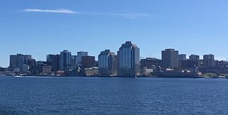
Halifax, officially known as the Halifax Regional Municipality (HRM), is the capital of the Canadian province of Nova Scotia. It had a population of 403,131 in 2016, with 316,701 in the urban area centred on Halifax Harbour. The regional municipality consists of four former municipalities that were amalgamated in 1996: Halifax, Dartmouth, Bedford, and Halifax County.

North End, Halifax Subdivision in Nova Scotia, Canada

The North End of Halifax is a subdivision of Halifax, Nova Scotia occupying the northern part of Halifax Peninsula immediately north of Downtown Halifax. The area once included historic Africville, and parts of it were severely damaged in the Halifax Explosion during World War I. A neighbourhood with strong African Nova Scotian roots, more recently the area has undergone gentrification.

Spring Garden Road, Halifax Community in Nova Scotia, Canada

The Spring Garden Road area, along with Barrington Street is a major commercial and cultural district in Halifax, Nova Scotia, Canada. It acquired its name from the fresh water spring that flows directly beneath it. It comprises Spring Garden Road, South Park Street, and a number of smaller side streets. The area is considered to be one of the trendiest areas in Halifax and is one of the busiest shopping districts east of Montreal.

St. Matthews United Church (Halifax) church building in Nova Scotia, Canada

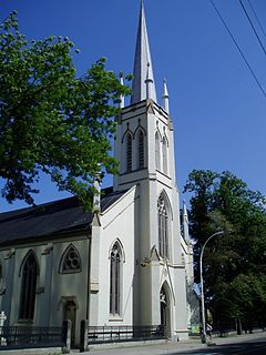
St. Matthew's United Church is a United Church of Canada church in downtown Halifax, Nova Scotia. The church was founded at the same time as the original colony in 1749 as a home for the various groups of dissenting Protestants who were from New England and who did not follow the Church of England. It originally met Sunday afternoons in St. Paul's Church, the Church of England building completed in 1750. The church got its own home in 1754 when a church was constructed at Hollis and Prince Streets. This building was destroyed by fire in 1857, and a new church was built at the current location at 1479 Barrington Street, land parcelled off of the Black-Binney House estate by Bishop Hibbert Binney. The church used the Old Burying Ground.

Fenwick Tower (Halifax) Residential skyscraper in Halifax, Nova Scotia

Fenwick Tower is a residential apartment building in the south end of Halifax, Nova Scotia, Canada. At 98 metres and 33 storeys in height, it is the tallest building in Atlantic Canada and the tallest building in Canada east of Quebec City.

Downtown Halifax Downtown Area in Nova Scotia, Canada

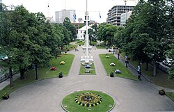
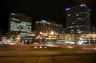
Downtown Halifax is the city centre of Halifax, Nova Scotia. Located on the eastern-central portion of the Halifax Peninsula, on Halifax Harbour, it serves as the business, entertainment, and tourism hub of the region.

Scotia Square

Scotia Square is a commercial development in Downtown Halifax, Nova Scotia, Canada. It was built in the late sixties to mid seventies and is managed by Crombie REIT. It is connected to the Downtown Halifax Link and serves as a major Halifax Transit bus terminal in Halifax.

Downtown Halifax Link

The Downtown Halifax Link system is similar to Toronto's PATH or Montreal's RÉSO system, but on a much smaller scale. It consists of a network of climate-controlled pedways connecting various office buildings, hotels, parkades, and entertainment venues around downtown Halifax, Nova Scotia, Canada. These walkways are all open to the public, and are convenient during inclement weather and the winter months.

Culture of Halifax, Nova Scotia

Hosting the region's largest urban population, Halifax, Nova Scotia is an important cultural centre in Atlantic Canada. Halifax is home to a vibrant arts and culture community that enjoys considerable support and participation from the general population. As the largest community and the administrative centre of the Atlantic region since its founding in 1749, Halifax has long-standing tradition of being a cultural generator. While provincial arts and culture policies have tended to distribute investment and support of the arts throughout the province, sometimes to the detriment of more populous Halifax, cultural production in the region is increasingly being recognized for its economic benefits, as well as its purely cultural aspects.

History of Halifax (former city) Urban Community in Nova Scotia, Canada

Halifax, Nova Scotia was originally inhabited by the Mi'kmaq. The first European settlers to arrive in the future Halifax region were French, in the early 1600s, establishing the colony of Acadia. The British settled Halifax in 1749, which sparked Father Le Loutre's War. To guard against Mi'kmaq, Acadian, and French attacks on the new Protestant settlements, British fortifications were erected in Halifax (1749), Bedford (1749), Dartmouth (1750), and Lawrencetown (1754). St. Margaret's Bay was first settled by French-speaking Foreign Protestants at French Village, Nova Scotia who migrated from Lunenburg, Nova Scotia during the American Revolution. All of these regions were amalgamated into the Halifax Regional Municipality (HRM) in 1996. While all of the regions of HRM developed separately over the last 250 years, their histories have also been intertwined.

St. Pauls Church (Halifax) Church in Nova Scotia, Canada

St. Paul's Church is an evangelical Anglican church in downtown Halifax, Nova Scotia, within the Diocese of Nova Scotia and Prince Edward Island of the Anglican Church of Canada. It is located at the south end of the Grand Parade, an open square in downtown Halifax with Halifax City Hall at the northern end. Built during Father Le Loutre's War, it is the oldest surviving Protestant church in Canada and the oldest building in Halifax. There is also a crypt below the church. Close to the church is the St. Paul's Church Cemetery. The official chapel of the church was the Little Dutch (Deutsch) Church.

Barrington Street street in Nova Scotia, Canada

Barrington Street is a major street in Halifax, Nova Scotia, Canada, running from the MacKay bridge in the North End approximately seven kilometres south, through Downtown Halifax to Inglis Street in the South End. The civic numbers range from 950 to 4756 on the Halifax Peninsula street grid numbering system.

Halifax City Hall city hall

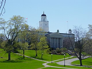
Halifax City Hall is the home of municipal government in Halifax, Nova Scotia, Canada. Designed by architect Edward Elliot and constructed for the City of Halifax between 1887 and 1890, it is one of the oldest and largest public buildings in Nova Scotia. The property was designated a National Historic Site of Canada in 1997.

Queen Elizabeth II Health Sciences Centre Hospital in Nova Scotia, Canada

Queen Elizabeth II Health Sciences Centre, in Halifax, Nova Scotia, Canada, is a large teaching hospital and Level 1 Trauma Centre affiliated with Dalhousie University. The QEII cares for adult patients. Pediatric patients within this region are cared for at the IWK Health Centre. Administratively, the QEII is part of the Nova Scotia Health Authority. The pipes in some parts of the QEII have been contaminated with legionella bacteria since the 1980s, which has rendered the building's water undrinkable.

Timeline of Halifax, Nova Scotia history

This timeline of the History of the Halifax Regional Municipality documents all events that had happened in Halifax, Nova Scotia, Canada, including historical events in the former city of Dartmouth, the Town of Bedford and Halifax County. Events date back to the early-18th century and continue until the present in chronological order.

Rocky Jones Canadian politician

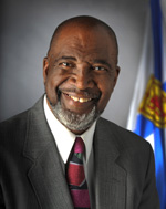
Burnley Allan "Rocky" Jones was an African-Nova Scotian and an internationally known political activist in the areas of human rights, race and poverty. He came to prominence first as a member of the Student Union for Peace Action (SUPA) during the 1960s and then as a civil rights activist, community organizer, educator, and lawyer.

Leslie R. Fairn Canadian architect

Leslie Raymond Fairn was a Canadian architect whose career is notable for its longevity and for the range of styles it encompassed, including Beaux Arts and Modernism. Most of his work was completed in the Maritimes.

CBC Radio Building (Halifax)

The CBC Radio Building was a landmark Streamline Moderne-style office building located in Halifax, Nova Scotia overlooking the Halifax Citadel and Halifax Public Gardens which served as the home of CBC Radio in Nova Scotia from 1944 to 2014.

George Henry Wright Canadian businessman

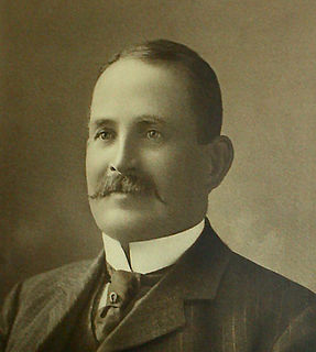
George Henry Wright was a significant business man and philanthropist in Halifax, Nova Scotia. He was born at Wright's Cove, Nova Scotia and died in the sinking of the Titanic at the age of 63. He established Write's World Business Directory in Boston and later returned to Halifax and invested in the city. His own house at 989 Young Ave, and two of his public buildings, the Marble Wright Building and The Saint Paul Building, still stand in downtown Halifax. They were all built by architect James Charles Philip Dumaresq.

Argyle Street (Halifax)

Argyle Street is located in downtown Halifax, Nova Scotia, Canada. It is four city blocks and approximately 460 metres long. The street is a popular centre for live music, nightlife, theatre, and al fresco dining.

References

  1. 1 2 3 4 5 6 7 8 9 10 11 12 13 Cuthbertson, Brian (1999). "History of the Grand Parade and Halifax City Hall". Journal of the Royal Nova Scotia Historical Society. 2: 70–93. ISSN   1486-5920.
  2. Oostveen, Lauren (29 October 2009). "From the Vaults: Grand Parade". Spacing Atlantic.
  3. "Grand Parade". Canada's Historic Places. Archived from the original on 8 March 2016. Retrieved 24 August 2015.
  4. "Grand Parade Flagpole Delivery photographs (Retrieval code: CR 6-027)". HRM Archives. 1947.Missing or empty |url= (help)
  5. Heller, Liane (10 August 2013). "ON THE BUS: In praise of buses and the Beatles". Halifax Chronicle-Herald.
  6. 1 2 3 Labrecque, Mike (1 May 2003). "Parking Improvements - Grand Parade" (PDF). Halifax Regional Council. Archived from the original (PDF) on 4 March 2016. Retrieved 21 August 2015.
  7. English, Dan (6 December 2004). "Parking - Grand Parade" (PDF). Halifax Regional Council. Archived from the original (PDF) on 4 March 2016. Retrieved 24 August 2015.
  8. 1 2 3 4 Shaw, Kyle (8 March 2007). "Driven to madness". The Coast.
  9. "No parkade at Grand Parade: Halifax staff". CBC News. 26 February 2007.
  10. "Grand Parade, the ex parking lot". The Coast. 27 February 2007.
  11. "Slain peace officers memorial unveiled in N.S." CBC News. 17 October 2010.
  12. Thompson, Allan (14 August 1994). "It may be her 17th visit to Canada...". Toronto Star. p. A1.
  13. Bousquet, Tim (October 15, 2011.) "Occupy Nova Scotia Takes to Grand Paradea." Thecoast.ca. Accessed October 2011.
  14. (October 20, 2011.) "Rain washes out Nova Scotia roads." CBC.ca. Accessed October 2011.
  15. Bousquet, Tim (5 November 2009). "Grand Parade ready to remember". The Coast.

Coordinates: 44°38′55″N63°34′31″W / 44.6486°N 63.57520°W / 44.6486; -63.57520